

In the eighth century, a Chinese scholar-official by the name of Jia Dan 賈耽 (730-805) recorded a great deal of geographic information about foreign lands as well as the routes to and through those lands.
A few itineraries that he compiled are included in the New History of the Tang (1060 AD), and in 1904, a young French Sinologist by the name of Paul Pelliot translated and wrote about a couple of those itineraries in a long article entitled “Deux itinéraires chinois de Chine en Inde à la fin du VIIIe siècle” (BEFEO 4: 131-413).
One of these itineraries went through maritime Southeast Asia, and while that might seem like a relatively obscure topic, in fact, in discussing this itinerary, Pelliot went a long way towards establishing how modern scholars should understand information about Southeast Asia in early Chinese sources, and he also set the foundation for what I call the “Srivijaya is a kingdom at Palembang that was referred to in Chinese sources as (Shili)Foshi and Sanfoqi” narrative, an idea that crystalized in a 1918 article by Pelliot’s compatriot, George Cœdès, but which has important roots in “Deux itinéraires.”
I am convinced beyond a shadow of a doubt that the “Srivijaya is a kingdom at Palembang that was referred to in Chinese sources as (Shili)Foshi and Sanfoqi” narrative is horrifically flawed, and we can likewise see the roots of some of those flaws in Pelliot’s “Deux itinéraires.”
To understand this requires a great deal of discussion. I will begin in this post by looking at a few phrases in the itinerary. However, as will become clear, even in looking at something as limited in scope as we will here, requires an immense amount of discussion to show how Pelliot was wrong and what is more likely to be accurate.
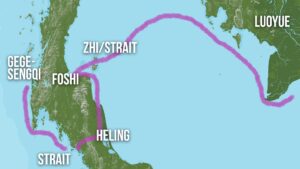
The itinerary in question begins in Guangzhou, and proceeds to what is now the southern coast of Vietnam. What we will look at below is a passage that is about the leg of the itinerary that one traversed after moving beyond the southern tip of the Indochinese Peninsula.
In a nutshell, Pelliot saw the itinerary as going directly south to the Strait of Malacca. I, by contrast, can demonstrate with much more defensible evidence than Pelliot mustered that the itinerary followed the southern coast of the Indochinese Peninsula, and then crossed over the Gulf of Thailand to the area around what is now Ko Samui and Surat Thani province in southern Thailand.
The Strait of Malacca
Here is how Pelliot translated the passage that we will examine.
又五日行至海硤,蕃人謂之「質」,南北百里,北岸則羅越國,南岸則佛逝國
Puis, après cinq jours de route, on arrive à un détroit que les barbares nomment Tche 質. Du nord au sud, il a cent li. Sur la côte septentrionale, c’est le royaume de Lo-yue 羅越; sur la côte méridionale, c’est le royaume de Fo-che 佛逝. (372-373)
Then, after five days’ travel, one arrives at a strait which the barbarians call Zhi 質. From north to south it is one hundred li. On the northern shore is the kingdom of Luoyue 羅越; on the southern shore is the kingdom of Foshi 佛逝.
Let us begin by discussing “Zhi.” Pelliot was convinced that this indicated the Strait of Malacca. Here is what he said:
There is no doubt that this strait is the Strait of Malacca. The duration of the voyage from Canton to the Straits is therefore about twenty days in Jia Dan; this is roughly what is found in other texts as well. That one could have gone from Phanrang to the entrance of the Strait in seven days seems to be confirmed by the History of the Ming, which reckons eight days’ journey from the capital of Champa (that is, presumably Quy Nhon) to Longyamen on the Bintang side. Indeed, according to the Ming yitong zhi and the Guangdong tong zhi, one goes in five days from the capital of Champa to the coast of Sumatra, which definitely seems very rapid, even with a favorable wind, for junks. (217-281)
Ok, so Pelliot concludes that “Zhi” refers to the Strait of Malacca and, great Sinologist that he was, he did this by looking at texts from two completely different time periods. . .
Jia Dan’s itinerary appears in the eleventh-century New History of the Tang, but he himself was active in the eighth century and reportedly completed a work with the above itineraries in 801 AD. The History of the Ming, meanwhile, was compiled over a period of many years in the late-seventeenth and early-eighteenth centuries and was completed in 1739.
Further, the information in the History of the Ming that Pelliot refers to appears at the beginning of a section that collects information about the historical interactions between the Ming and Melaka. It is the first line of that account, and it is there to describe Melaka’s geographic location.
This is clearly information that was written by one of the compilers of that text. Therefore, the difference in time between the information that Jia Dan recorded and these remarks could be as much as 900 years!!
Knowing that Pelliot used an early-eighteenth-century text to talk about information that could date from the eighth century. . . I’m not sure if I should laugh or cry. . . but this is not in any way shape or form a sign of good scholarship/Sinology.
This is what the History of the Ming says:
滿剌加,在占城南。順風八日至龍牙門,又西行二日即至。或云即古頓遜,唐哥羅富沙。
Manlajia [Melaka] is south of Zhancheng [Champa]. With a favorable wind, it takes eight days to reach Longyamen; going a further two days west, one arrives there. Some say it is the ancient Dunxun, the Geluofusha of the Tang.
Interesting. As I’ve written before, scholars in the late-Ming and early-Qing tried to equate current places with ancient placenames. These were often “invented connections,” but you can sometimes discern a logic to their associations.
Melaka was an important trading port at the time that the History of the Ming was compiled, and many centuries earlier, Dunxun 頓遜 (or Dianxun 典遜) had been as well. These two places, however, were far apart. I think every scholar today would place Dunxun somewhere in what is now Surat Thani province at the eastern terminus of an overland trade route.
Where, however, was Geluofusha? If we look in the very same text that Jia Dan’s itinerary is recorded in (the New History of the Tang), we see that it was also known as Geluo 箇羅 and Geluofushaluo 哥羅富沙羅, and that it is said to have been to the southeast of a place called Panpan 盤盤.
Where was Panpan? The same text, the New History of the Tang, says that “Panpan was at a bend of the Southern Sea. To its north, separated by the Lesser Sea, was Huanwang; it adjoined Langyaxiu. Traveling by sea from Jiaozhou, one reached it in 40 days” (盤盤,在南海曲,北距環王,限少海,與狼牙脩接,自交州海行四十日乃至。).
Ok, now we are getting places that we can make sense of. Huanwang referred to a place in what is now central Vietnam. Langyaxiu is, I would argue, Langkasuka on the Malay Peninsula in the area of what is now Pattani.
In between those two places, Panpan was located, and it took 40 days to get there from Jiaozhi, or what is now northern Vietnam.
While these are not exact comparisons, there are two issues that we can see here: 1) travel times during the Tang and the Ming were obviously not the same as there was this little thing called “advances in navigational technology” that took place in the centuries between these two time periods, and 2) note how the New History of the Tang is recording travel to the northern end of the Malay Peninsula in reference to Panpan.
We’ll return to that issue below. Here, we will continue examining Pelliot’s study by looking at what he says after discussing “Zhi.” In particular, he goes on to translate Jia Dan’s text by saying “From north to south it is one hundred li. On the northern shore is the kingdom of Luoyue; on the southern shore is the kingdom of Foshi.”
The Kingdom of Luoyue
So, there are two places here that we need to identify. The first is Luoyue 羅越. Pelliot placed Luoyue on the northern shore of the Strait of Malacca somewhere near what is now Johor. In doing so, he rejected claims by other scholars that this indicated a place in what is now Thailand or Cambodia.
Of these claims, the one he spent the most time rejecting is one by Schlegel who had argued that Luoyue referred to Longvek (Lawek), a place to the south of the Tonle Sap in what is now Cambodia.
Here is what Pelliot wrote:
This leaves Schlegel’s opinion. But first of all, it is not only arbitrary, but certainly false, to reconstruct the old pronunciation of Lo-yue as Lo-wak: yue is a character that originally had a final dental; the guttural has been introduced here only for the needs of the identification. As for this Lawék—an ancient city of Cambodia according to Pallegoix, an old name of Ayutthaya according to the late king of Siam, and supposedly “without the slightest doubt” identical with Lo-yue—there is a strange confusion here. Lawék, or rather Lovèk, is indeed the name of a Cambodian city, the remains of which are found somewhat north of Oudong and which, in the fifteenth century, had become, after Angkor and Babaur, the capital of Cambodia. But it is immediately obvious that this Lovèk of Cambodia, in the middle of the Mekong basin, can have nothing to do with the Lawék of the late king of Siam on the lower Menam.
Moreover, this name Lawék in Siam is doubtful. According to Siamese tradition, Ayutthaya was founded in 1350; Mr. Aymonier proposes lowering this date by about a hundred years. In any case, nothing indicates that there had previously been an important city there. On the other hand, Ayutthaya is not very far south of Lopburi, which in all probability is the old Lvo or Lavo, and, without meaning any disrespect to the learned king Mahā Mongkut, one may ask whether in the remarks attributed to him there is not some confusion between Lopburi and Ayutthaya.
One must also remember that his notes, before appearing in the Chinese Repository, from which they were later reprinted in Sir John Bowring’s work, were “prepared for the press” by Doctor Dean, and we do not know exactly how far this “preparation” went. The sentence in question is itself regrettably ambiguous; and moreover, is it not possible that when Mahā Mongkut said or wrote that before the foundation of Ayutthaya there had been no other important center in the region than Lavo, a Cambodian center, Doctor Dean—perhaps unaware of the earlier Cambodian domination in Siam—took it upon himself to substitute for Lavo the name Lawék (Lovèk), which at least for him was indeed in Cambodia?
Be that as it may, the identification of Lo-yue with Lawék rests solely on Schlegel’s assertion, and it is contradicted by all the known facts. For the present, we must continue to place Lo-yue in the Malay Peninsula, Lo-hou at Lopburi, and the land of Sien on the upper Menam.
Did you get that? Are you convinced?
No, even if you got that, you can’t possibly be convinced.
What do we see here? We see Pelliot, great Sinologist that he was, rejecting an idea about the meaning of a term in an eleventh-century Chinese text by talking about comments made in the nineteenth century and their possible distortions. . .
That is not sufficient to reject the idea that Luoyue could have indicated Longvek. Nonetheless, having convinced himself of this, Pelliot then interpreted all of the related evidence to fit his view that Luoyue was somewhere near Johor.
For instance, there is a brief entry on Luoyue in the New History of the Tang that states the following:
羅越者,北距海五千里,西南哥谷羅。商賈往來所湊集,俗與墮羅鉢底同。歲乘舶至廣州,州必以聞。
Luoyue is at a distance of 5,000 li north of the sea, and to its southwest is Geguluo. Merchants traveling to and fro gather there. Its customs are the same as those of Duoluobodi [Dvaravati]. Each year they come by ship to Guangzhou, and the prefecture [meaning Guangzhou] invariably reports this.
Pelliot discussed this passage by stating that:
Jia Dan’s itinerary provides us with one firm indication: Luoyue, whatever its extent to the north may have been, included present-day Johore. As for the note in the History of the Tang, it is absurd as it stands. One might well think of reading shi 十, ‘ten,’ instead of qian 千, ‘thousand’; but if Luoyue is placed 50 li from the sea, then the phrase ‘it is a meeting place’ would have to be referred to Ge Guluo, and that can hardly apply to anything but a seaport. Yet the Chinese text does not seem to me to lend itself easily to that interpretation. We shall see later that the position of Ge Guluo itself is uncertain. The similarity of customs between Luoyue and Dvāravatī, aside from being a rather vague indication, only leads us to look for Luoyue in the Malay Peninsula, which was thoroughly penetrated by Mon-Khmer domination; and we already suspected as much. (232-233)
Ok, let’s remember that this was written over 100 years ago, and that there is a lot that we know now but which Pelliot didn’t know then.
For instance, I don’t think anyone today would see the southern end of the Malay Peninsula as related to Dvaravati, a polity and cultural world that scholars today identify with the area of the Chao Phraya River plain in what is now Thailand.
Seeing Longvek as similar to Dvaravati, however, does make sense. That is because it is the Chao Phraya River plain and Cambodia that were “thoroughly penetrated by Mon-Khmer domination,” not the southern end of the Malay Peninsula.
Nonetheless, having determined by comparing texts produced close to seven centuries apart that Jia Dan wrote about the Strait of Malacca, and having rejected the idea that the term Luoyue in an eleventh-century Chinese text could have been Longvek by referencing nineteenth-century comments and their distortions, and convinced that the southern end of the Malay Peninsula had been “thoroughly penetrated by Mon-Khmer domination,” Pelliot likewise interpreted another passage in the New History of the Tang that mentions Luoyue as referring to a place near Johor.
Jia Dan’s Itinerary from Central Vietnam to Cambodia
In particular, Jia Dan also recorded information about a route that extended overland from what is now central Vietnam into Cambodia. The concluding information about that itinerary is as follows:
又三日行至文單外城,又一日行至內城,一曰陸真臘,其南水真臘。又南至小海,其南羅越國,又南至大海。
After another three days’ travel one reaches the outer city of Wendan; after another day one reaches the inner city. It is also called Land Zhenla; to its south is Water Zhenla. Going further south one reaches a small sea; south of that is the kingdom of Luoyue; further south is a great sea.
I think, as did Pelliot, that Wendan might have been Sambor Prei Kuk. Regardless of whether or not that is correct, it was obviously in or very near to “Cambodia,” as it was also known as “Land Zhenla,” and everyone agrees that Zhenla referred to a place in the area of what is now Cambodia.
So, from someplace in Cambodia, you went further south and there was a small sea (xiaohao 小海), then a place called Luoyue, and then a great sea (dahai 大海).
I have not capitalized these terms, and I will explain why below, but based on this passage alone (without looking at other passages or texts), these terms could be read as proper nouns, that is, the Small Sea and the Great Sea.
In any case, I see the small sea, the kingdom of Luoyue, and the great sea mentioned in this passage as referring to the Tonle Sap, Longvek (a place that was similar to Dvaravati), and the Gulf of Thailand.
Meanwhile, Pelliot translated these places as “une petite mer,” “le royaume Lo-yue,” and “l’Océan” (372). Note how he treated the great sea as a proper noun, l’Océan, but the other is “a small sea.” We cannot make such a distinction from the wording in this text.
In any case, convinced that Luoyue was somewhere near Johor, Pelliot interpreted these places to mean the Gulf of Siam/Thailand, a place near Johor, and “the Ocean.”
Which “Ocean” was this? Pelliot didn’t say. In this long article, Pelliot placed his translations of Jia Dan’s itineraries at the end, and then discussed them in the article. He has “l’Océan” in the translation, but did not discuss what it refers to when he addressed this part of the itinerary in the article.
By contrast, he did discuss in a footnote what he thought “une petite mer” referred to. In footnote 1 on page 232 he noted that “This name ‘small sea,’ applied to the Gulf of Siam, appears again in the passage of the Jiu Tangshu [Old History of the Tang] (juan 197, fol. 2r) where it is said that Water Zhenla ‘to the south borders on a small sea.’
Indeed, the fuller passage in the Old History of the Tang states that:
水真臘國,其境東西南北約員八百里,東至奔陀浪州,西至墮羅鉢底國,南至小海,北即陸真臘。
The kingdom of Water Zhenla: its territory measures approximately 800 li from east to west and from south to north. On the east it reaches the region of Bentuolang [Panduranga]; on the west it reaches the kingdom of Duoluobodi [Dvaravati]; on the south it reaches a small sea; on the north is Land Zhenla.
First, note here how Water Zhenla is described as bordering Dvaravati. Again, given that Luoyue was compared to Dvaravati, it makes much more sense to see it in Cambodia, a place that was connected to Dvaravati, than at the end of the Malay Peninsula.
This, and all the other points above, together with Pelliot’s failure to explain what “l’Océan” refers to is already more than enough to refute his claim that Luoyue was somewhere near Johor, and to place it instead in Cambodia.
Small Seas and Geographic Space
However, it is true that the use of the term “small sea” in the Tang histories is confusing. In pre-Tang historical sources, we see that the main trading centers in this region were at Funan 扶南, in “Cambodia,” and Dunxun 頓遜 (or Dianxun 典遜), in the area of what is now Surat Thani province in southern Thailand. The sea in between was referred to as the Zhanghai 漲海, or “Swelling Sea.”
While we no longer see this term used in the Tang period, I don’t see clear evidence that terms like “small sea” or “great sea” had been adopted in the same sense and used consistently. Hence, my decision not to capitalize them.
Instead, they appear to be used in these passages descriptively and inconsistently. For instance, in the account of Panpan, cited above, we see it located in the Southern Sea (Nanhai 南海), and separated from Huanwang by the Lesser Sea (Shaohai 少海).
As such, given that we do not find consistent usage of sea terms in Tang sources, I see no problem in identifying the “small sea” in Jia Dan’s itinerary (and in the context of that itinerary) in the New History of the Tang as referring to the Tonle Sap, and the small sea in the description of Water Zhenla (and in the context of that description) in the Old History of the Tang as indicating the Gulf of Thailand.
Further, when one examines Jia Dan’s itinerary from central Vietnam to Cambodia, as I did here, one sees that it is very detailed in discussing places between central Vietnam and Wendan, but that for the final three places (the small sea, Luoyue, the great sea), it is not as detailed.
Logically, that makes sense, as Chinese were probably using this route to trade overland with Cambodia at Wendan, and were not frequently going past that point to the sea, because if they wanted to go to the sea to the south of Cambodia, they could do so by ship. They didn’t need to first go overland from central Vietnam.
So, that can explain why the information about the final three places is a bit vague, however, we still have to understand that information in terms of the scale and shape of the space that Chinese were active in at that time.
Pelliot imagines the detailed itinerary from central Vietnam to Cambodia suddenly leaping across the Gulf of Thailand down to Johor, a place thoroughly penetrated by Mon-Khmer domination of Dvaravati (another distortion of space), and then out to a great Ocean somewhere. . . I guess the Indian Ocean?
Indeed, nothing that we can see with clarity in the Tang dynastic histories is quite at that scale, and it is definitely not in that shape or formation. The geographic space that gets discussed in the maritime region of Southeast Asia is the area between Cambodia or Champa and the trans-peninsular crossing at what is now Surat Thani province, that is, the two ends of the geographic space where trade took place.
Further, Jia Dan mentions this as well when he states that “On the northern shore is the kingdom of Luoyue; on the southern shore is the kingdom of Foshi.”
If we look at Song dynasty sources like Zhou Qufei’s 周去非 1178 work, the Lingwai daida 嶺外代答 [Representative Responses about the Region Beyond the Passes], and Zhao Rukuo’ 1225 work, the Zhufan zhi 諸蕃志 [Treatise on the Various Barbarians], we find a geographical distinction about the places to the north and south of the Gulf of Thailand in the form of the two terms, Upper Shore (Shang’an 上岸) and Lower Shore (Xia’an 下岸).
It is clear to me that Jia Dan expressed this same concept in saying that “On the northern shore is the kingdom of Luoyue; on the southern shore is the kingdom of Foshi.” This was the northern and southern shores of the Gulf of Thailand, the place where “Zhi” (I’ll return to that below) was located, and which were separated by 100 li.
Luoyue was an important trading center on the northern shore, and Foshi was an important trading center on the southern shore. Further, both of these places were in the same general areas as the earlier two important trading centers at Funan and Dunxun.
What is more, we also see this in the statement mentioned above about Luoyue’s location that “Luoyue is at a distance of 5,000 li north of the sea, and to its southwest is Geguluo” (羅越者,北距海五千里,西南哥谷羅。)
I agree with Pelliot that the number 5,000 is likely incorrect, and while he struggled to find an inland location to place Luoyue near Johor, his idea to correct this number to a distance of 50 li can enable us to nicely place Longyue right in the area of Longvek, in contact with the world of Dvaravati and just to the south of the little sea of the Tonle Sap, where it obviously was located.
While it can be difficult to locate Geguluo with precision, we find many places with this type of name (starting with “ge” which is clearly the Mon-Khmer term, “ko,” meaning “island”) on the western side of the Malay Peninsular near the terminus of the trans-peninsular crossing from Surat Thani province. There, one also finds clear archaeological evidence of the existence of historical trading centers, such as at Takua Pa in Phang Nga province
Again, the relationship between Luoyue and Geguluo represents the same geographic space that is referenced over and over. It is pointing to the area where there was a key trading route, and in particular, to key trading centers on both ends of that route.
Foshi
One of the important trading centers in that space was a place called “Foshi” 佛逝.
Let’s take a look at what Pelliot had to say about Foshi (I have changed his transliterations to Pinyin to make them more recognizable to readers today).
Oh, and you really should buckle up, because you’re going for a ride!!
The name Foshi 佛逝 is also written Foshi 佛誓, and it is also found in the fuller forms Shilifoshi 室利佛逝 or Shilifoshi 尸利佛誓. I believe it was Stanislas Julien who first pointed this out in his Méthode; he reconstructed it as Śrībhoja. In 1883–1886, when publishing the Book of the Marvels of India, Van der Lith, in connection with the country of Serboza, a vassal of Zabedj, recalled that Mr. Groeneveldt had compared this name, then read Sarbaza, with that of the state of Sanfoqi 三佛齊, which the Chinese knew in Sumatra from the end of the tenth century down to the fifteenth; now this state of Sanfoqi is generally placed at Palembang [cites Groeneveldt here].
At the same time, Reverend Beal provided Van der Lith with a note on the country of Foshi or Shilifoshi, which appears several times at the end of the seventh and the beginning of the eighth century in Yijing’s works. Twice, a note in Yijing’s text says that the former Moluoyou 末羅遊 had become the present Shilifoshi. Now Marco Polo, at the end of the thirteenth century, mentions a country called Malaiur, which Yule is inclined to place at Palembang. Beal had no doubt that Yijing’s Moluoyou was Marco Polo’s Malaiur, and therefore Palembang. But Moluoyou is Shilifoshi; on the other hand, there was at Palembang the state of Sanfoqi; it therefore becomes highly probable that the two names Shilifoshi and Sanfoqi are related.
Beal accordingly proposes to restore Sanfoqi as Sambhoja, “the Bhojas united,” relying on the existence of the form Foshi, Bhoja, alongsideShilifoshi, Śrībhoja. As for Sarbaza (Serboza), although he does not state so formally, he believes it to be identical with Śrībhoja. Yijing also names, to the west of Shilifoshi, a country called Poluoshi 婆魯師. Beal recalls that some texts give the name Bosi (properly speaking, Persia) to the western part of Sumatra; he thinks this Poluoshi or Bosi should be identified with Marco Polo’s Basma, the Malays’ Pasei, and the Portuguese Basem. Finally, Yijing says that from Moluoyou he went to the country of Jiecha 羯荼; Beal recognizes in this the well-known name of Kedah.
There you have it folks: the connection between (Shili)Foshi and Sanfoqi. . . the foundation of the “Srivijaya is a kingdom at Palembang that was referred to in Chinese sources as (Shili)Foshi and Sanfoqi” narrative. . .
I have already written more than 5,000 words. To go through this passage and point out all of its flaws will take at least another 5,000. I will do that in a future post. For now, let me just note that,
1) Recently, Pierre-Yves Manguin, who has built an entire career on the ideas in that passage, published a piece where he dismissed my work and stated that “in Chinese historical texts, the placename Sanfoqi is closely associated with its predecessor Shilifoshi.”
There is no such close association. That “association” comes from what we see above: Scholars, over 100 years ago, imagining Indic names from various Chinese terms and then seeing them as signifying each other, etc.
Meanwhile, at no place in any premodern Chinese source do we find any association between (Shili)Foshi and the later kingdom of Sanfoqi.
2) There is no possible way to get Foshi to indicate “Vijaya,” because among other things, it also appears in the Tang period as Foshiduo 佛逝多, and there is no way to get “Vijaya” from that.
3) Together with plenty of other people over the years, I locate (Shili)Foshi somewhere around Surat Thani province, and there are multiple sources that can be used to make that case, including some of the ones that the gentlemen above misunderstood and distorted (again, I will write about that later).
Foshi could have been in the same place as the earlier Dunxun. Or perhaps it was in a slightly different location. It’s difficult to say, but it was definitely in that area.
Further, from all of the other information that we have discussed above, it should be obvious that Jia Dan was not talking about the Strait of Malacca, and that the southern half of the Malay Peninsula was not clearly in the known world of Chinese in the eighth century. They only dealt with the upper part of that peninsula.
And it is there that we find a place called “Zhi.”
Zhi
When you sail along the southern coast of the Indochinese Peninsula and then cut across the Gulf of Thailand, the single most significant geographic feature you see as you head from the Norther/Upper Shore to the Southern/Lower shore are the two islands of Ko Pha Ngan and Ko Samui.
If we return now to Jia Dan’s itinerary, Pelliot translated part of the passage we are looking at here by stating that in departing from the end of the Indochinese Peninsula, “after five days’ travel, one arrives at a strait which the barbarians call Zhi” (又五日行至海硤,蕃人謂之「質」).
What Pelliot translated as “a strait” (un détroit), is the expression, haixia 海硤. The first character, hai, means “sea” and the second character, xia, and its equivalent, xia 峽, literally refer to something like a valley stream between two mountains or a narrow waterway between two mountains. However, in a maritime context, this can refer to a strait, or more simply, a narrow passage between two pieces of land, such as two islands.
That is a perfect description of Ko Samui and Ko Pha Ngan. What is more those two islands are the only such significant geographic feature in that area, whereas down in the Strait of Malacca area (which by this point, hopefully you can see that there is no reason for us to consider), there are many such narrow waterways between islands, and as a result, this geographic marker would be meaningless.
So, that being the case, is there any evidence for a “Zhi” in that area? Yes, I think there is.
There is a fourth-century text attributed to the Daoist, Ge Hong 葛洪 (283–343 CE), called the Grand Clarity Scripture of Divine Elixir Made from Liquid Gold (Taiqing jinye shendan jing 太清金液神丹經) that contains information about a port on the eastern side of the Malay Peninsula somewhere near where Dunxun/Dianxun was located, that is, somewhere around Surat Thani province.
This is what it says:
句稚國,去典遜八百里,有江口,西南向,東北入,正東北行,大崎頭出漲海中,水淺而多慈 [8a] 石,外徼人乘舶船皆鐵葉,至此崎頭,閡慈石不得過,皆止句稚,貨易而還也。
The kingdom of Gouzhi/Juzhi 句稚 lies 800 leagues from Dianxun 典遜. There is a river estuary that faces to the southwest and which you enter from the northeast. Proceeding directly northeast, one reaches a large cape that juts into the Swelling Sea [Zhanghai 漲海]. The water here is shallow and filled with lodestones [ci shi 慈石]. Foreign merchants who travel in ships sheathed in iron reach this cape, but because of the lodestones, their ships are blocked and cannot pass. Therefore, they all stop at Juzhi, where they conduct trade and then return.
This passage appears to clearly describe the area of Surat Thani, with the cape to its south that extends into the sea towards Koh Samui and Ko Pha Ngan.
Further, the “gou/ju” in Gouzhi or Juzhi (it has two possible pronunciations) 句稚, I would argue, is probably the Mon-Khmer term for an island, “ko.” This could have thus been Zhi Island.
Finally, the location of Gouzhi/Juzhi is in precisely the place where I would argue that Jia Dan’s itinerary went. It did not go from the end of the Indochinese Peninsula to the Strait of Malacca, but instead, along the southern short of the Indochinese Peninsula, past the greater Dvaravati world that culturally included Longvek, and then it cut over to the only significant landmark in that area, the two islands of Ko Pha Ngan and Ko Samui, before proceeding southward along the coast of the Malay Peninsula (which we will look at in the next post).
To the locals, that area was (Ko) Zhi.
Geoff Wade’s Translation
In 2013, historian Geoff Wade published a translation of Jia Dan’s itinerary in an article entitled “Maritime Routes Between Indochina and Nusantara to the 18th Century” (Archipel 85: 83-104).
This is how he translated the passage we have been examining here, and I have included his footnotes.
Then after a further five days of sailing, one reaches the strait, [19] which the natives call “zhi.” [20] It is 100 li [21] from north to south. [22] On the northern shore is the country of Loyue, [ 23] while on the southern shore lies the country of Foshi. [24]
19. Likely the Straits of Singapore.
20. Some scholars consider this to be a rendering of the Malay term “sělat”, but the correspondence is not unquestioned, given the Late Middle Chinese reconstruction of the pronunciation as either tri or tsit. See Edwin G. Pulleyblank, Lexicon of Reconstructed Pronunciation in early Middle Chinese, Late Middle Chinese and early Mandarin, Vancouver, UBC Press, 1991, pp. 406 and 408.
21. A li is a measure of distance, equivalent to approximately 0.5 kilometres.
22. Possibly the Straits between the island of Singapore and the islands of Bintan and Batam.
23. Some scholars identify the name Loyue with the toponym Johor, but the phonetic similarity is less than convincing. Others claim that it represents the word laut, but again this is unlikely to have been the name of a polity.
24. Foshi = Vijaya. In this case, a reference to Srivijaya.
So, as you can see, from Paul Pelliot in 1904 to Geoff Wade in 2013, our knowledge about Jia Dan’s itinerary did not advance at all. . . Nor, apparently did our knowledge about Luoyue, or Foshi, or Zhi, etc.
Is this because Paul Pelliot was such a great Sinologist that there is simply nothing more that we can possibly say? No, I think that somewhere in the now 7,000 words that are up above here we can easily find a thing or two to improve upon Pelliot’s work. . .
So, what then was up with Geoff Wade? In 2013, I think many people considered Wade to be a leading expert on maritime Southeast Asia in Chinese sources, and he may have even been working at the Nalanda-Sriwijaya Centre in Singapore at that time. . . Is it really the case that he simply could not find anything to update in Pelliot’s 100+-year-old-outdated ideas?
As the Japanese say when they are bewildered and can’t fathom an answer, “Saaaaa…..”
While I may have been a bit mean or rude in discussing Pelliot’s work, work that was produced over a century ago and, therefore, obviously must have weaknesses, those comments are ultimately directed at everyone who has relied on Pelliot in the century since and who has not challenged what he wrote (and by that I mean his fundamental ideas, not tiny details), particularly those who are supposed to be able to read Chinese.
What I pointed to above were “easy targets,” or “low-hanging fruit,” that is, passages that are very easy to determine are inadequate, even for people who are not Sinologists, and yet. . . more than a century later. . . He’s still here!!
Needless to say, all of this is about much, much more than an eighth-century itinerary, because in the understanding of that eighth-century itinerary of Pelliot, Wade and countless others are the core ideas that established the “Srivijaya is a kingdom at Palembang that was referred to in Chinese sources as (Shili)Foshi and Sanfoqi” narrative.
While we are only a few phrases into that itinerary, that narrative has already crumbled in the discussion above. Nonetheless, it is important to continue looking at this narrative, as well as what Pelliot thought and Wade didn’t change, as there are other issues that we need to address, and also because I now understand that it is only after this narrative has been thoroughly demolished that people will perhaps be able to recognize the more accurate, and defensible, understanding of the past that I have developed.

I am somewhat attracted by the five days from the south of Champa to Sanfoqi, so quickly looked through some texts. The Song huiyao “fanyi” 4.61 gives a length of five days journey from Zhancheng to Sanfoqi (see also Songshi), but it also gives two days to reach Mayi and seven days to Puduan. If these last two locations are indeed in the Philippines (Mait and Butuan), which is doubtful (for in the 10th century there was a Mayi in the western archipelago), the journeys seem to short. So the distances are either all correct or all wrong. The Daoyi zhilüe reports a full five day journey from Longyamen to Sanfoqi, but there is no indication how long it took from Zhancheng to Longyamen. Lastly, the Zuiwei lu of the late Ming remarks that Longyamen is located to the northeast of Sanfoqi. As to the Da Ming Yitong zhi entry quoted by Pelliot, it is noteworthy that the Da Qing Yitong zhi while copying the entry from the earlier work, dropped the info on the five day travel.
Locations thus remain “fluid”.
Thank you for the comments!!
There are a few things that I would say in response.
1) Yes, I REALLY find it difficult to place Mayi and Puduan in the Philippines. I will try to look into this more, but it seems very difficult to make that case.
2) Most trading polities in this time period were up a river. So, for distances, it can be unclear if people mean from one trading port to the next, or from the river mouth that goes to a trading port to the next river mouth that goes to a trading port, etc.
The early-nineteenth century Vietnamese text that I wrote about recently is interesting as it looks at “estuaries” (haimen 海門) and talks about where places were in relation to those river mouths and where the rivers went to. In general, however, you don’t get that kind of detail.
3) I’m convinced that there was more than one “Longyamen” (Dragon Teeth/Tooth Gate), and for the one that is mentioned in relation to Sanfoqi, we can see that the distance between it and Sanfoqi is the distance moving inland because it says something about “trading 1/3 of one’s goods” (or maybe it’s getting them taxed?) at Longyamen before proceeding to Sanfoqi.
4) A long time ago, I translated the first part of the Vietnamese chronicle, the Dai Viet su ky toan thu. The first part is almost entirely based on Chinese sources, so you can compare what is in the DVSKTT with what is in various Chinese dynastic histories.
What I found, was that although at times the information in the DVSKTT might constitute a condensed version of what was in Chinese sources, in general, the information was the same, with one major exception: numbers.
And with numbers, it was almost like an exception if they didn’t get them wrong. They almost always got them wrong (I’m probably exaggerating, but I came across many such cases).
So, in copying texts, numbers are the most likely to get distorted. Next in line, I would argue, are directions. And for that, I notice it in my own life. In teaching, there are countless times when I said “north” when I meant to say “south,” etc.
5) Sometimes we can use the internal logic of a text to determine an error, but at other times we do not have the evidence to do so.
To give an example of when we can use the internal logic of a text to determine an error, there is a reference to Luoyue that I did not mention above, because what I wrote was already too long, but it is in this passage in the History of the Song:
丹眉流國,東至占臘五十程,南至羅越水路十五程,西至西天三十五程,北至程良六十程,東北至羅斛二十五程,東南至闍婆四十五程,西南至程若十五程,西北至洛華二十五程,東北至廣州一百三十五程。
“The country of Danmeiliu: eastward to Zhanla is 50 cheng; southward by water route to Luoyue is 15 cheng; westward to Xitian is 35 cheng; northward to Chengliang is 60 cheng; northeastward to Luohu is 25 cheng; southeastward to Shepo (Java) is 45 cheng; southwestward to Chengruo is 15 cheng; northwestward to Luohua is 25 cheng; northeastward to Guangzhou is 135 cheng.”
If we see Longyue as being at Longvek, everything here can make sense except for the statement that “northeastward to Luohu is 25 cheng,” because Luohu (Lavo/Lopburi) was to the west of Longvek in what is now Thailand.
But then notice that the northeast is mentioned two times. After the cardinal directions of east, south, west, north, the northeast appears as the first intercardinal direction and again at the end as the last intercardinal direction.
That’s weird. So, then if we consider that the traditional way of listing the eight directions is to go east, south, west, north, southeast, southwest, northwest, and northeast (八方 = 東、南、西、北、東南、西南、西北、東北), then we can make the case that the first northeast, and that’s the one that mentions Luohu, isn’t supposed to be there.
Finally, the place that this is about, Danmeiliu 丹眉流, is usually written as Danliumei 丹流眉, so it looks like that is wrong too.
This is something that we can sometimes definitely detect. I see cases like this as moments when the woodblock carver came back from lunch and was still in a bit of a daze from his post-lunch nap and made a couple of mistakes before an overseer came by and wacked him on the head to get him to wake up and concentrate.
However, at other times, there is no such evidence to go on, so we always have to be careful and skeptical with numbers and directions.
I think it’s absurd to think that those ancient navigators went south as it was apparently much easier to go east west in those days but north south. As a result the trans bengal and trans gulf of Thailand were already done in the fourth century.
Also the prevailing ocean currents would have made the Pelliot’s journey very difficult. 賈耽 didn’t take that adventure, and would have stuck to the already established trade route, that is Malay peninsula. Island Jawa was almost completely out of radar.
Selat Melaka was not commonly used before the 14th century.
The ports on its east coast, chumpon, chaiya, ligor, patalung, patani would be the terminal ports of entry for the Chinese and others coming from the east.
Sounds all too logical to me.
Thank you for the comment!! I completely agree with your common sense, and can provide lots of historical evidence to support it.
Unfortunately, this common sense has long been absent in the field of Southeast Asian history, and as a result, what I have written here is considered by “the experts” to be a “radical” reading of the historical sources. . .
By contrast, I think it would be a lot more accurate to label Pelliot’s hallucinations as “radical.” 🙂