By this point, it should be apparent to anyone who has read the previous three posts in this series that Paul Pelliot’s 1904 article, “Deux itinéraires chinois de Chine en Inde à la fin du VIIIe siècle,” is deeply and fundamentally flawed.
That 1) Pelliot got fundamental information so fundamentally wrong, and that, as we will see below, 2) no one since has ever seriously questioned and examined what he wrote, has created an unmitigated disaster for the field of early Southeast Asian history.
At this point, the received “knowledge” of early Southeast Asia is simply unusable.
Let us look at some examples of what has been written in the more than century since Pelliot published his article.
1911: Friedrich Hirth, W. W. Rockhill, Chau Ju-kua. On the Chinese and Arab Trade in the Twelfth and Thirteenth Centuries. (St. Petersburg: Imperial Academy of Sciences, 1911).
In 1911, in the introduction to their translation of Zhao Rukuo’s 1225 Zhufan zhi, Hirth and Rockhill included their translation of Jia Dan’s itinerary. Here is what they wrote (I have changed their Romanizations to Pinyin, but for the works I cite after this one, I have left them in their original form):
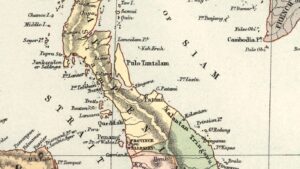
Then after five days’ travel one comes to a strait which the Barbarians call Zhi (質). [4] From the south to the north it is 100 li. On the northern shore is the country of Luoyue (羅越) [5]; on the southern coast is the country of Foshi (佛逝) [6].
To the east of the country of Foshi, travelling by water for four or five days, one comes to the country of Heling (訶陵) [7]; it is the largest of the islands of the south. Then east(west?)ward, going out of the strait, after three days, one comes to the country of Gegesengqi(or di) 8 (葛葛僧衹 or 袛) [8], which is an island separated at the north-east point from Foshi. The people of this country are pirates and cruel; sailors dread them. (11)
4) Pelliot sees in this the Strait of Malacca. I agree with Gerini (J. R. A.S., 1905, 505) in thinking it was the Singapore strait.
5) The southern extremity of the Malay Peninsula, or Ligor. Gerini, Researches on Ptolemy’s Geography of Eastern Asia, 820.
6) Eastern Sumatra. According to our text the voyage from Canton to E. Sumatra occupied 20 days; this is exactly the time taken by the pilgrim Yijing to make it, Chavannes, Relig. émin., 119.
7) Java, but see infra, p. 78, n. 1. [And that long note makes reference to, among other things, Shlegel’s views, which he discussed in Part 2, but ultimately sides with Pelliot in believing that it Heling indicated Java].
8) Possibly the Brouwers islands, as suggested by Pelliot, op.cit.,839. Gerini, Researches, 816, 817 identifies this island with Pulo Medang, the old designation of which was Kūkor. It lies W. of the mouth of the Siak river, E. coast of Sumatra or Pulo Siak.
As damaging as Pelliot’s 1904 article was, I suspect that this English-language translation has probably had an even more pernicious influence on subsequent scholarship.
Understanding Pelliot’s 1904 article is difficult, as related information appears in different parts of the paper, and both in the text and in the footnotes. Further, his writing was unfocused as he frequently went off on tangents.
By contrast, Hirth and Rockhill boiled all that chaos down into a short passage of clear information. While this makes for an easier read, it also conceals the countless ways in which Pelliot’s flawed ideas become apparent when we examine his actual writing and arguments.
That said, even in this streamlined version there are still clues that point to the flaws in this reading. For instance, when we see a footnote for Luoyue that says “The southern extremity of the Malay Peninsula, or Ligor,” that is a sign that there is an issue there that needs to be investigated further.
1919: Gabriel Ferrand, “Le K’ouen-louen et les anciennes navigations interocéaniques dans les mers du sud,” Journal Asiatique (Juillet-Aoūt 1919): 5-68.
In 1919, Arabist Gabriel Ferrand took a slightly different view of Jia Dan’s itinerary than Pelliot had. Ferrand could not read Chinese, so he had to follow what Pelliot wrote. Nonetheless, he found information in an Arabic text that he argued could help clarify what Pelliot had written.
So, following Pelliot, Ferrand saw the itinerary as heading directly south from the Indochinese Peninsula, and that it then recorded an eastward detour to Java.
Where Ferrand differed from Pelliot is that whereas Pelliot had argued that a reference to then “exit the strait” referred to the Strait of Melaka, Ferrand argued that this was either the Sunda Strait or the Gaspar [i.e., Gelasa] Strait, and that the route then proceeded up the western coast of Sumatra.
The Gelasa Strait is between the now Indonesian islands of Belitung and Bangka, off the southeastern end of the island of Sumatra. Ferrand believed that in the placename, Gegesengqi 葛葛僧祇, there was a link to that strait.
Pelliot and Ferrand both believed that the final two characters of that placename, sengqi 僧祇, indicated “negroes.” As Pelliot stated, “The name Gegesengqi remains mysterious to me; perhaps the final part should be read sengqi; but this term, which properly designates negroes, is of no help to us here” (348).
More specifically, Pelliot and Ferrand saw sengqi as a Chinese transcription of the Arabic/Persian term, Zanj / Zangī / Zanjī, a term, in medieval usage, for Black Africans, especially those associated with East Africa.
The topic of sengqi/Zanj opens another can of worms, and one that is helpful, but not essential for understanding the flaws in the extant scholarship. I will leave that for a future blog post. Let us continue here with Ferrand’s argument.
Ferrand argued that in ibn Mājid’s 1462 work, Hāwiya, there is mention of a “Selat Zangi (literally, the strait of the Zangi, of the Negro)” (54) in a passage about the area between Melaka and Java. In the image below of a translation of this part of Ferrand’s article, one can get a sense of how he made his argument.
Wow! There is a lot to unpack there, but ultimately, it’s just not worth doing so as 1) the evidence that we covered in Part 1 makes it obvious that Jia Dan’s route did not go down to the area of the Strait of Malacca, and 2) as I will show at some point later, we can place Gegesengqi in the area around Takua Pa at the northern end of the Malay Peninsula.
1950: Lawrence Palmer Briggs, “The Khmer Empire and the Malay Peninsula,” The Far Eastern Quarterly, Vol. 9, No. 3 (May, 1950): 256-305.
In 1950, diplomat and historian Lawrence P. Briggs wrote the following (emphasis mine):
In a long and magistral article, which lies at the base of the historical geography of all the countries of Southeast Asia, Pelliot discussed two itineraries prepared during the Chen-yüan period (785-804) by Chia Tan. These itineraries ran from China to India, one by land and one by sea. The latter set out from Canton. Leaving Pulo Condor – Pelliot quotes from the Hsin T’ang shu – “after five days’ sailing, one arrives at a strait which the barbarians call Tche [Chih]. From north to south, it is 100 Ii. On the northern shore, is the kingdom of Lo-yue [Lo-yüeh]. On the southern shore, is the kingdom of Fo-che [Fo-shih]…. Then, toward the west, setting out from the strait, one arrives at the kingdom of Ko-ko-seng-tche [Ko-ko-seng-chih], which is on an island, separated from the northwest corner of Fo-che [Fo-shih]…. Chih is evidently the Strait of Malacca, including Singapore Strait at its entrance. Fo-shih here probably means all the coast of Sumatra along the strait included in the empire of Srilvijaya. Ko-ko-seng-chih was probably an island off the coast of Sumatra. (271)
As we can see, and not surprising given his praise, Briggs followed Pelliot. Further, with the mention of “Srivijaya,” we can also see that Briggs followed the ideas of George Cœdès’s 1918 article where he equated Foshi with Srivijaya and placed that polity at Palembang. That is a topic that will require a separate series to discuss.
1958: Wang Gungwu, “The Nanhai Trade: A Study of the Early History of Chinese Trade in the South China Sea, Journal of the Malayan Branch of the Royal Asiatic Society, Vol. 31, No. 2 (1958): 1, 3-135.
This article came from Wang Gungwu’s recently-completed MA thesis at the University of Malaya, and it contained the following information about Jia Dan’s itinerary:
. . . and 5 days (further to the south-east) to a Straits, 100 li from north to south, “which the barbarians call che” (Straits of Malacca, perhaps including the Straits of Singapore), and 3 days sailing westwards out of the Straits to Ko-Ko-seng-ti Kuo, many of “whose people were devoted to robbery and plunder, and were much feared by those who travel in ships” (possibly Brouwers Islands, or an island at the mouth of the Siak river. . . (105)
Wang notes in the text that “The identifications suggested here in brackets are based on the discussions of Pelliot, op. cit., pp.200-219 and pp. 349-355; Hirth and Rockhill, op. cit., pp.10-12 and p.51.”
Everything is the same as what the scholars he cited had written, but Wang left out the passage about the route to Heling, which Pelliot saw as a “FYI detour” to Java.
Further, as a reader of this blog pointed out, Wang Gungwu’s work was republished, unrevised, in 1998 by Times Academic Press in Singapore.
1961: Paul Wheatley, The Golden Khersonese: Studies in the Historical Geography of the Malay Peninsula before A.D. 1500 (Kuala Lumpur : University of Malaya Press, 1961).
In 1961, geographer Paul Wheatley published a work that contained translations and his interpretations of passages in early Chinese texts that pertain to the Malay Peninsula.
To this day, Wheatley is widely regarded and respected as an authority on this topic. Let us look at what he wrote about Jia Dan’s itinerary.
After five days journey [from Chün-t’u-lung Mountain] one reaches a strait which the barbarians call Chih, and which is 100 li from south to north. On its northern shore is the kingdom of Lo-yüeh, on its southern shore the kingdom of Fo-shih. [11]. Some four or five days’ journey over the water to the eastward of Fo-shih is the kingdom of He-ling (Java), the largest of the islands of the south. Then emerging from the strait, in three days one reaches the kingdom of Ko-ko-seng-chih, [1], which is situated on another island off the north-west corner of Fo-shih. The inhabitants are mostly pirates. Voyagers on junks go in dread of them. (56-7)
11. Specifically Palembang; possibly here used for the whole island of Sumatra.
1. Pelliot (BEFEO, tome iv, 1904, p. 349) suggests one of the Brouwers Islands. It is not impossible, despite the use of the word 島 [meaning “island”], that Ko-ko-seng-chih was part of the north-east Sumatran mainland.
We see here that Wheatley simply followed Pelliot. Further, like Pelliot, Wheatley could not figure out where to place Gegesengqi, “a separate island at the northwestern corner of Foshi.”
Although he did not use the term “Srivijaya,” in equating Foshi with Palembang, we can see that Wheatley was following George Cœdès’s 1918 article.
Again, this is why Pelliot’s article is so important, because as Briggs noted in 1950, this article “lies at the base of the historical geography of all the countries of Southeast Asia.”
Unfortunately, however, it is a flawed base, and that is why scholar after scholar, in following the base that Pelliot established, has failed to get Jia Dan’s itinerary to make sense, just as Pelliot could not get it to make sense, and this has enormous ramifications for everything that has been written about early Southeast Asia.
1967: O. W. Wolters, Early Indonesian Commerce: A Study of the Origins of Śrīvijaya (Ithaca: Cornell University Press, 1967).
Historian O. W. Wolters was a key proponent of the “Srivijaya is a kingdom at Palembang that was referred to in Chinese sources as (Shili)Foshi and Sanfoqi” narrative that was developed from the writings of George Cœdès and Paul Pelliot, and in this 1967 work, he included the following information about Jia Dan’s itinerary:
And then five days to a strait which foreigners call chih. [96] From north to south it is a 100 li in width. On its northern shore is Lo-yüeh country. On its southern shore is Fo-shih country [Srivijaya]. If one goes by sea to the east from Fo-shih country for four or five days one reaches Ho-ling country, which is the largest island in the south. Proceeding westwards from the strait one reaches in three days Ko-ko-seng-chih country. It is a separate island lying off the north-western corner of Fo-shih. Many of its people are robbers and those who sail in ships fear them. (187)
96. Pelliot in 1904 suggested the possibility that chih was derived from the Malay sêlat, or ‘strait’, ‘Deux itinéraires’, 231, note 5.
Wolters then wrote that “Professor Wheatley believes that Lo-yüeh was a southerly part of the Malay Peninsula. Pelliot identified the Ko-ko-seng-chih island with one of the Brouwers islands lying opposite the state of Johore at the tip of the Peninsula.” (188)
As we saw in Part 1, there are various references to Luoyue that either place it in the area of Cambodia or connect it to Dvaravati, a polity and cultural world centered in the area of the Chao Phraya River plain. Not surprisingly, not long before Pelliot published his article, Dutch Sinologist Gustaaf Schlegel had argued that Luoyue referred to Longvek in what is now Cambodia.
Pelliot, dismissed this information, and again as we saw in Part 1, he provided no convincing evidence to support his ideas. Wolters followed Pelliot and made the following comments about Luoyue later in his book:
. . . Lo-yüeh, a kingdom which Chia Tan [Jia Dan] later describes as laying at the extreme southern end of the west coast of the Malay Peninsula. [38] “Traders passing back and forth meet there [at Lo-yüeh]. The customs are the same as those of To-lo-po-ti [a seventh century transliteration of Dvaravati]. Every year merchants embark on junks and come to Canton, whence the news of their arrival must be passed on.” [39] (235)
38. See at note 97 in Chapter 12.
39. HTS, 222B, 5b. Professor Wheatley’s translation is followed; Golden Khersonese, 58.
Note 97 in Chapter 12: HTS, 43 B, 18b. Translations of this itinerary are available in Pelliot’s ‘Deux itineraires’, 372-373, Wang Gungwu’s ‘The Nanhai trade’, JMBRAS, 31, 2 (1958), 104-105, and in Wheatley’s Golden Khersonese, 56-57.
What Wolters did here was to accept the interpretation of Pelliot (repeated in Wang and Wheatley) that the Luoyue in Jia Dan’s itinerary was “at the extreme southern end of the west coast of the Malay Peninsula.” He then cited a passage in the New History of the Tang (HTS = Hsin T’ang shu = Xin Tangshu), following its translation in Wheatley’s work, that equated the customs of Luoyue with those of Dvaravati.
Now, the idea that a place at the southern tip of the Malay Peninsula would somehow be associated with Dvaravati is absolutely ludicrous to me, and I would think, to anyone else. The only way for this to make sense would be if Chinese at this time referred to everyone everywhere in the region as being somehow “Dvaravati,” but we don’t see that.
However, I wasn’t sure if perhaps in the 1960s that was an accepted idea. So, I checked George Cœdès’s The Indianized States of Southeast Asia, a 1968 translation of his 1948 Les états hindouisés d’Indochine et d’Indonésie, but he saw Dvaravati as located in the Chao Phraya River plain, and as separate from the area of the Malay Peninsula.
Again, like the statement in a footnote in Hirth and Rockhill about Luoyue that it was either “the southern extremity of the Malay Peninsula, or Ligor,” information like that above in the New History of the Tang is the type of information that should lead a scholar to think: “Wait! Is this idea that Luoyue was at the end of the Malay Peninsula actually correct?”
And a scholar should follow up on that question by looking closely at what is recorded in the sources. However, this is precisely what “scholar” after “scholar” has failed to do.
In double-checking the publication information for this book online, I stumbled across the following review of it on Amazon written in 2008 by epigrapher Anton Zakharov.
This monograph by O.W. Wolters first published in 1967 and reissued in 2008 deals with the world-economy system between the 4th and 7th centuries. It shows the development of trade routes and ties between China, Southeast Asia, India, and the Western World. The origins of the well-known polity Srivijaya were connected by Wolters with the transformation and fluctuations of world trade system. He offered a coherent view on the early history of Srivijaya as well as on any early polity of Indonesia and the Malay peninsula, for example Langkasuka or Tambralingga. A curious fact is that it’s one of the very few monographs on Srivijaya ever existed (together with a book by Nilakantha Sastri published in 1949, and the collected essays of two great French scholars G. Coedes and L.Ch. Damais edited by Pierre-Yves Manguin in 1992).
Certainly, this book is completely scientific. It creates some difficulties in reading but here you can enjoy followability of the author’s reasoning and investigation.
However, I should emphasize that despite the merits of Wolters’s book a considerable progress in our knowledge of Southeast Asia was made from the 1980ies. P.-Y. Manguin and his French and Indonesian colleagues undertook successful archaeological research in Sumatra and in Java. Many Srivijayan sites were discovered near Palembang and Jambi. The island of Bangka also gave some data on early history of Indonesia. Many other discoveries from all early Southeast Asia give possibility to re-study a history of world-trading system.
By the way, if you want to know what Srivijaya was and how it emerged, how ancient trade was perceived by Chinese and how it was organized, I highly recommend you this excellent monograph by O.W. Wolters.
This was written in 2008. I’m not sure if Professor Zakharov still holds such high praise for Wolters, Manguin, and the writings on “Srivijaya,” but I think it would be helpful for him to read the posts in this series, as I am confident that after doing so, it will no longer be possible for him, or anyone else, to refer to the work of Wolters, or any of the scholarship on early Southeast Asia that follows Pelliot (which is basically everything), as “completely scientific.”
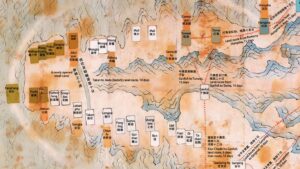
Finally, while we are still talking about Wolters, he has maps in his 1967 work which nicely illustrate a point that I made in Part 3, which is that while scholars are willing to recognize that overland trade took place in the area of the Isthmus of Kra in the early centuries AD, after that they assume that ships suddenly starting sailing directly south from the end of the Indochinese Peninsula.

Note in particular in the map on the right the straight double line from Canton to the southeastern coast of Sumatra. In the legend for the map, Wolters labels this “Major ocean highway.”
2012: Angela Schottenhammer, The ‘’China Seas’’ in World History: A General Outline of the Role of Chinese and East Asian Maritime Space from its Origins to c. 1800,” Journal of Marine and Island Cultures, Volume 1, Issue 2 (2012): 63-86.
I could go on and on like this, citing work after work (from Brian Colless in 1969, to Dashu Qin and Kunpeng Xiang in 2011, to John Chaffee in 2018, etc.), but I think historian Angela Schottenhammer did a very good job of capturing the essence of the problem I am pointing out when she wrote in 2012 that (my emphasis):
Missions between the Persian Gulf and Guangzhou have already been described by Jia Dan 賈眈 (710–785). The passage is translated by Friedrich Hirth and Rockhill and therefore will not be repeated here. [92] (75)
92. Friedrich Hirth, W. W. Rockhill, Chau Ju-kua. On the Chinese and Arab Trade in the Twelfth and Thirteenth Centuries. (St. Petersburg: Imperial Academy of Sciences, 1911), 8–16. Jia Dan’s geographical treatise is the Huanghua sida ji 皇華四達記. See also M. Reinaud, Relations des voyages faits par les Arabes et les Persans dans l’Inde et â [à] la Chine au IXe siècle de l’ère Chrétienne, Tome 1. (Paris, 1895).
Indeed, what need is there to check or question something that was published a century ago?
By not doing so, what could possibly go wrong. . . ?
2017: Stephen Haw, “The Maritime Routes Between China and the Indian Ocean During the Second to Ninth Centuries C.E.,” Journal of the Royal Asiatic Society, Volume 27 , Issue 1 (2017): 53-81.
The one partial exception that we see to the unthinking repetition of Pelliot’s flawed ideas that has dominated the world of scholarship on early Southeast Asian history for more than a century is the above 2017 article by historian Stephen Haw.
To his credit, Haw recognized that Jia Dan’s itinerary did not pass through the Strait of Malacca. However, there is a lot that he did not recognize, such as the fact that Pelliot’s justification for seeing the itinerary go directly south from the Indochinese Peninsula is also flawed.
As such, Haw still tried to get the itinerary to proceed from somewhere around southern Sumatra, and ended up, like Ferrand a century earlier, arguing that it went through the Sunda Strait and up the west coast of Sumatra.
Everyone who has ever commented on this itinerary has assumed that it passes through the Strait of Melaka (at least as far as I am aware). It clearly does not. The fact that Barus is on the west coast of Sumatra should be sufficient indication of that fact. The other major issue is that, in order to force the itinerary into the Strait, it is necessary to regard the voyage from Srivijaya to Heling as a digression, although nothing in the original text suggests that it is. In fact, the reason why Pelliot had difficulty making sense of the itinerary after the supposed digression to Heling was precisely that he had taken a wrong turning, as it were. Once the false assumption that the itinerary passes through the Strait of Melaka is discarded, this section of the itinerary begins to become clear. (71) . . . I have to admit, however, that I cannot explain the name Gegesengzhi. (73)
I have not discussed the section of the itinerary that comes after one reaches Gegesengqi, which I have argued is up in the area near the archaeological site of Takua Pa in Phang Nga province in Thailand.
That topic intersects with another topic that requires a series of blog posts to explain, and that is the topic of Tang dynasty monk Yijing’s journey through the region.
However, to provide some key information here first. There were two places on the Malay Peninsula where the ocean-going vessels that journeyed between South Asia and Southeast Asia arrived at and departed from. One was in the area of Takua Pa, and the other was in the area of Kedah.
Further, there were two routes to South Asia. One went northward and then cut across the Bay of Bengal, whereas the other went southward to the west coast of Sumatra and then across to Sri Lanka. Jia Dan’s itinerary records that latter route, departing from the Takua Pa area. Again, I will explain this in more detail later.
Further, I can explain and document everything, including the location of Gegesengqi, which as we see above, Haw still couldn’t do, because again, the itinerary did not go through the Sunda Strait because it never went directly south from the Indochinese Peninsula in the first place.
Conclusion
I am going to conclude this series of posts on “From Pelliot to Wade: Jia Dan’s Itinerary Through Maritime Southeast Asia” here. As should be clear, the line from Pelliot does not go directly to the work of historian Geoff Wade in 2013, but instead, it goes through the work of virtually EVERY SCHOLAR who has ever written about early Southeast Asia.
One does not need to discuss Jia Dan to be influenced by this article. Instead, if one thinks that Foshi was at Palembang, or Luoyue was near Johor, or that Heling was Java, or that Chinese sailed directly south from the Indochinese Peninsula to the Malay Peninsula in the ninth century, then one is following Paul Pelliot’s 1904 article, “Deux itinéraires chinois de Chine en Inde à la fin du VIIIe siècle.”
Stephen Haw, who has been seen as somehow “revisionist,” also followed Pelliot.
Perhaps we could make an exception for Johannes Kurz, but he constitutes a unique case in that he focuses on pointing to the flaws in extant scholarship, but rarely attempts to build a cohesive narrative about the past, such as about Jia Dan’s itinerary. In other words, we know what he thinks is wrong in individual cases in the extant scholarship, and that is helpful, but unlike Haw, for instance, Kurz hasn’t produced work where he tries to bring together information to make a clear argument about what he thinks is right.
So, putting that case aside, EVERY SCHOLAR has followed Pelliot in believing that Jia Dan’s itinerary went directly south from the Indochinese Peninsula to the southern tip of the Malay Peninsula.
I am the ONLY SCHOLAR who has ever put forth the argument that the route went over the Malay Peninsula in the greater Lake Songkhla area. Not only is that immensely more logical and fit with the supporting historical evidence, but I can document my argument, and I do not end up with any “unexplainable” points, as has been the case with every other scholar before me.
As such, what I am saying is NEW because it is based on a completely different reading of the sources than the one (and there has only ever been “one”) reading that the entire tradition of scholarship on early Southeast Asia is based on. Therefore, it can’t be countered by going back to Pelliot, or Hirth and Rockhill, or Ferrand, or Briggs, or Wang, or Wheatley, or Wolters, or Shottenhammer, or Wade, or Haw, or countless others.
Instead, one has to go to the primary sources and examine the evidence, which is exactly what I have done, and which is what every scholar over the past century should have done. . . but didn’t/hasn’t.
Finally, my reading of the sources is not “radical” or “controversial.” Instead, it is extremely logical, common-sense, and firmly grounded in, and supported by, the historical sources.
Again, what I have written in these four posts is on the one hand about a seemingly obscure topic (the record of a ninth-century itinerary), but on the other hand, Paul Pelliot’s 1904 study of that obscure topic has played a central and enormously important role in shaping (really, determining) how scholars in the modern field of early Southeast Asian history understand the historical geography of early Southeast Asia that is recorded in Chinese sources.
And what I have shown is that everyone before me has misunderstood what is recorded in the Chinese sources, because EVERY.SCHOLAR.HAS.FOLLOWED.PELLIOT, who over a century ago, as a 26-year-old kid, wrote a pioneering article and who, not surprisingly, got a lot of things wrong. . .