

I have just shared a translation that ChatGPT and I made of the sections in Zhou Qufei’s twelfth-century Lingwai daida that relate to maritime Southeast Asia. I would like to now start discussing the information in that text.
I’ll begin by talking in general terms about the conceptions of space that we find in that text. There are detailed discussions about placenames that I can and will engage in later (and some of which I’ve already discussed in publications) to better document the points I make here, but in this blog post I want to start at a more general level by thinking about the overall conception of geographic space that we see in Zhou Qufei’s work.
Let’s start by looking at the section on “The Voyaging Foreign Barbarians.” That section mentions the routes from various places to China. Here is what it says about Sanfoqi:
三佛齊之來也,正北行,舟歷上下竺與交洋,乃至中國之境。其欲至廣者,入自屯門。欲至泉州者,人自甲子門。闍婆之來也,稍西北行,舟過十二子石而與三佛齊海道合於竺嶼之下。
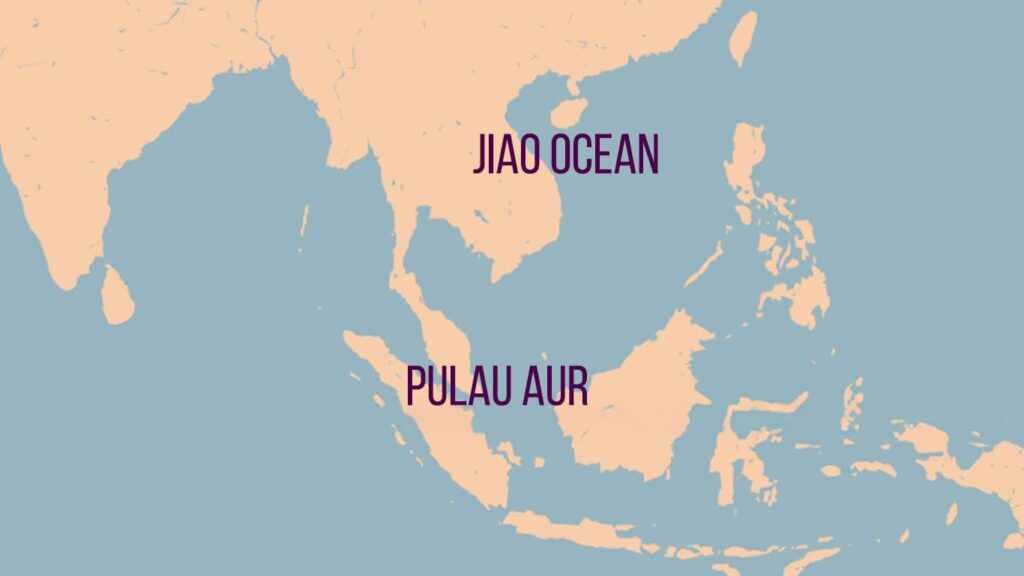
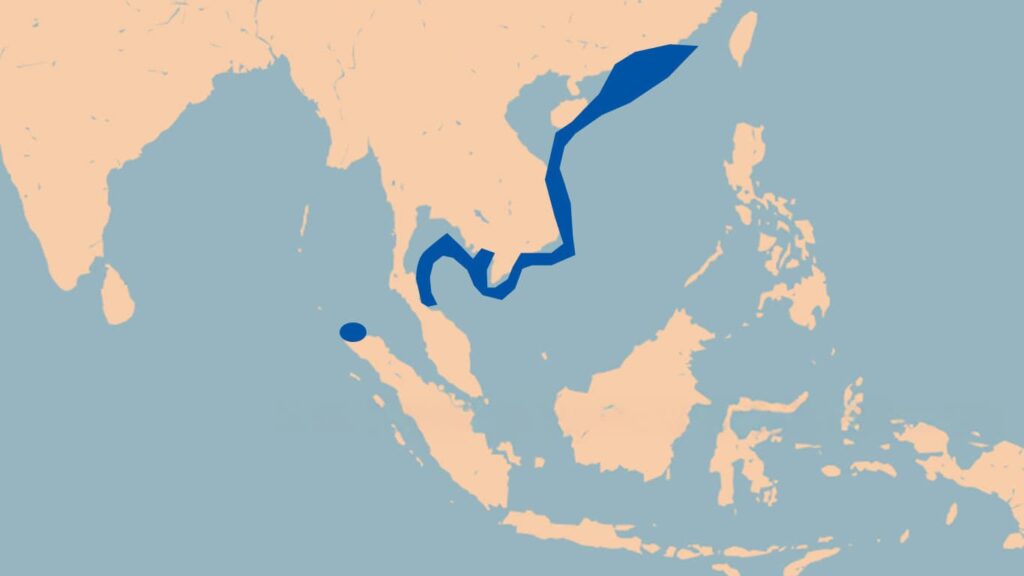
Sanfoqi is the central hub along the sea routes of the various kingdoms. Ships coming from Sanfoqi travel due north, passing through Upper and Lower Zhu [Shang Xia zhu 上下竺] and the Jiao Ocean [Jiaoyang 交洋] before reaching the Chinese coast.
If we follow the “orthodox” view of Southeast Asian history, then Sanfoqi is Palembang on the island of Sumatra, and the Upper and Lower Zhu is a reference to Pulau Aur, an island off the northern coast of what is now Johor, Malaysia.
The Jiao Ocean is written in sources variously as the Jiaozhi Ocean 交趾洋, the Jiaozhi Sea 交阯海, the Jiao Sea 交海, etc. I think all scholars agree that it refers to the area between Hainan and the Vietnam coast.
If Sanfoqi is Palembang, and Upper and Lower Zhu is a reference to Pulau Aur, then this passage leaves out the vast area between Pulau Aur and Champa.
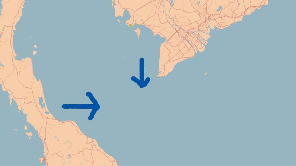
Let’s now look at Shepo, a place which the “orthodox” view argues is island Java. Zhou Qufei records that “Ships from Shepo travel a bit northwest, passing the Twelve Sons Rocks [Shi’erzi shi 十二子石], and merge with the Sanfoqi route below Zhu Islet [Zhuyu 竺嶼].”
Zhu Islet (or it could mean “the Zhu Islets”) can probably be seen as the same as Upper and Lower Zhu. As for the Twelve Sons Rocks, I’ve written about that location in my working paper, but for now, I’ll put that aside as it entails a detailed discussion.
If Shepo was island Java, then this would mean that you sail to the northwest until you reach Pulau Aur, and then you follow the same route as Sanfoqi, which again would mean that it says nothing about the vast distance between Pulau Aur and Champa.
So, as I mentioned in an earlier post, this understanding by modern scholars of not only this text but of all Song dynasty era texts means that the area from the southern coast of Cambodia to Sumatra and Java was essentially a “blank space” to the Chinese at that time.
And given that very little is recorded in Song dynasty era texts about Zhenla, the place scholars believe was Cambodia/Angkor, it means that they had extremely little knowledge of Cambodia and that the mighty Angkor had, from the perspective of Chinese sources, basically zero impact on maritime Southeast Asia. Instead, it was all about Palembang and Java, places, which as I’ve said previously, Arabic sources indicate that people from that part of the world did not visit. By contrast, their large ships went from Kalah (likely Kedah) which they said was a dependency of “Jaba,” to Tioman Island, and then Qmar (Khmer/Cambodia) and then Champa.
Then consider the line in the section on Sanfoqi in the History of the Song that says that Sanfoqi “neighbors Champa and is between Zhenla and Shepo” (與占城為隣,居真臘、闍婆之間,). This is a line that Groeneveldt (the guy Coedes relied on) either did not translate or was not in his version of the History of the Song and I have never seen anyone else discuss.
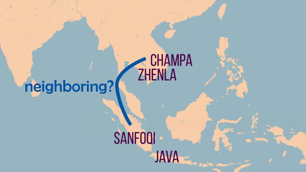
Ok, so stop and think about all of this. How could Palembang neighbor Champa and be between Zhenla and island Java?? And how could the Chinese record basically no information about Cambodia when Angkor was at its peak?
For all of this to make sense, our only option is to explain it away to a “crazy” medieval view of geography and to the incompetence of medieval Chinese chroniclers. There is no other way to get all of this information to “make sense” if we see Sanfoqi as Palembang and Shepo as island Java.
Yes, it is possible to see errors in medieval texts, and yes, it is possible to see different or inaccurate geographic concepts in the past, but in this case I think scholars have accepted far too many, and far too severe, geographic distortions in order to support the Srivijaya at Palembang theory.
The issue is that in reality everything was at a smaller scale than we have assumed. We can see this by looking at the section on “The Various Foreign Kingdoms across the Seas.” To quote:
正南諸國,三佛齊其都會也。東南諸國,闍婆其都會也。西南諸國,浩乎不可窮,近則占城、真臘為窊里諸國之都會。
For the kingdoms directly to the south, Sanfoqi 三佛齊 serves as the central hub. For the kingdoms to the southeast, Shepo 闍婆 serves as the central hub. As for the kingdoms to the southwest, the region is vast and seemingly boundless. The nearer parts include Champa 占城 and Zhenla 真臘, which serve as the central hub for Wali 窊里 and other kingdoms.
If we were to map this out following the “orthodox” view that Sanfoqi is Palembang and Shepo is island Java, it would look something like this:
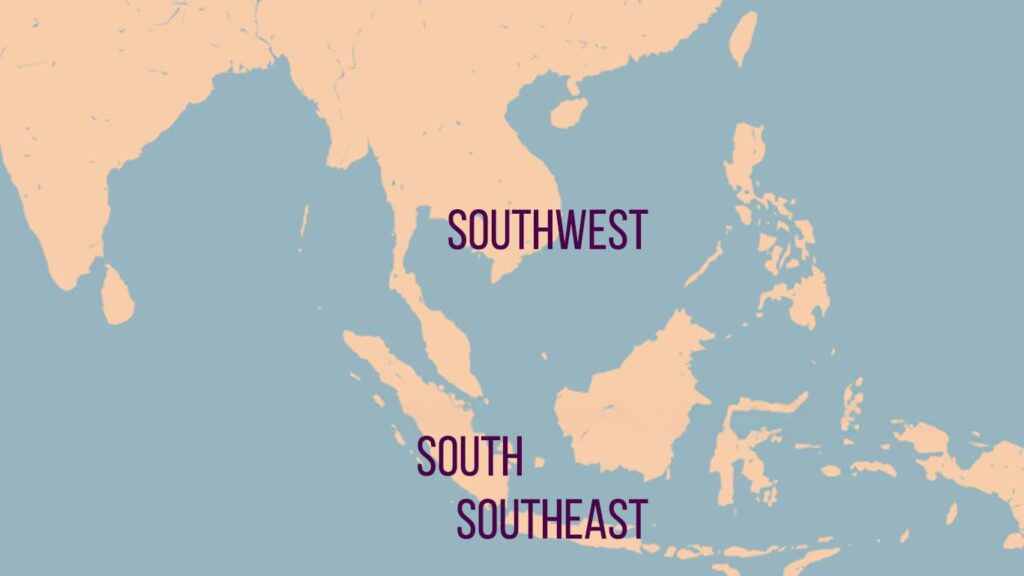
From our custom of viewing directions on maps, the above map can make sense in terms of its directions. However, I don’t think this is how Zhou Qufei was thinking. Someone needs to explain this to me, as I can’t recall exactly how it worked, but in this time period, when indicating directions in relation to China (as we see in the above passage), sometimes directions would be explained in the opposite way of how we think today.
So, for instance, in the slightly later Zhu fan zhi 諸蕃志 [Record of the Various Foreigners] (1225), Zhao Rukuo says that you go from China to the southwest to get to places in what is now the Philippines and to the southeast to get to places in what is now southern Vietnam.
We’ll return to that in a second, but let’s think first about scale. The region which Zhou Qufei says is “vast and seemingly boundless” is the one closest to China, the area around Champa and Zhenla.
Why would he say that? I think it’s because it’s the place Chinese actually knew the most about, precisely because it was the closest.
The Zhu fan zhi lists the vassal kingdoms of Zhenla, and they are the following: Dengliumei, Bosilan, Luohu, Sanpo, Zhenlifu, Maluowen, Luyang, Tunlifu, Pugan, Wali, Xipeng, Duhuai, and Xunfan.
A lot of these are places which we cannot identify. Pugan is Bagan and Luohu is in the area of the Chaophraya river valley, so that is indicating links across the northern edge of the Gulf of Thailand, links that had been in operation from distant antiquity. However, a bunch of these others were probably right in the area of the lower Mekong region.
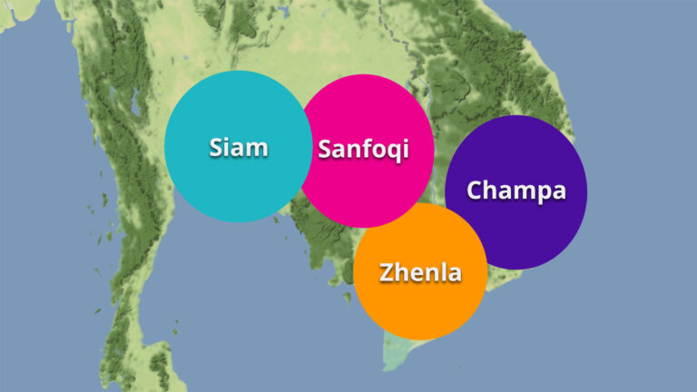
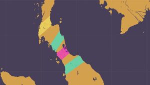
Let’s look at this map base on my understanding that Sanfoqi is Kambuja and Shepo is a reference to the area around Lake Songkhla, while also remembering that “southwest” and “southeast,” when indicating a direction in reference to China, were at times used in this period in the opposite way that we are accustomed to.
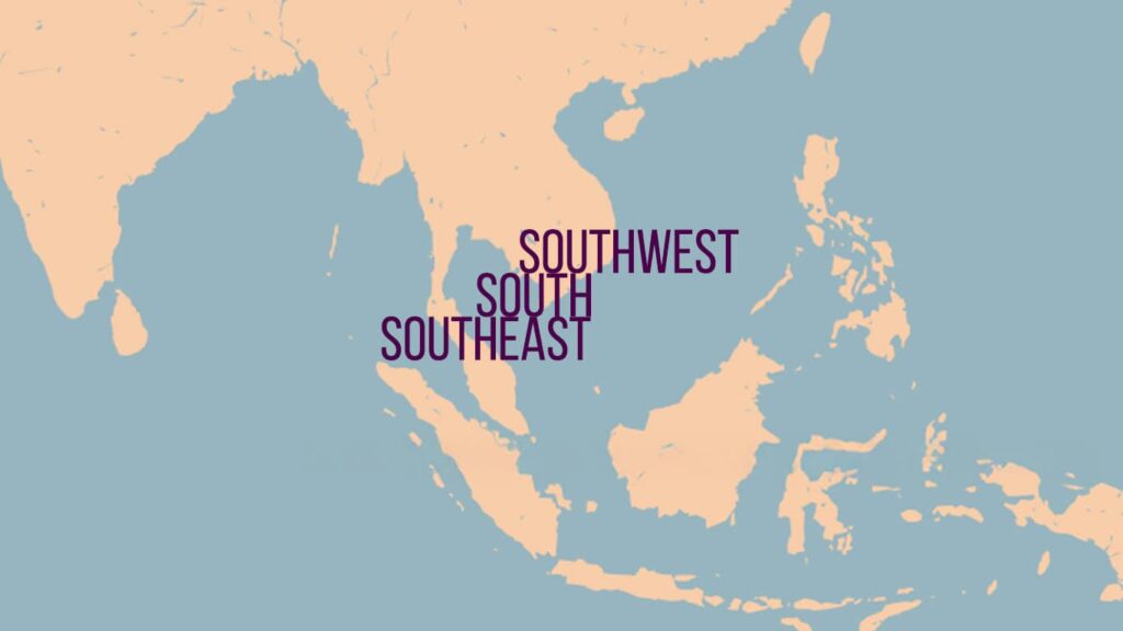
Here, obviously, everything is on a smaller scale, but that is precisely the point. Zhou Qufei was not writing about the south, southeast, and southwest of the world as we know it today. He was referring to the very limited view of maritime Southeast Asia that Chinese possessed in his day.
That area that they were the most familiar with looked something like this:
I’ve added the northern tip of Sumatra because Lamuri was mentioned by Zhou Qufei.
From this perspective, let’s continue with the section on “The Various Foreign Kingdoms across the Seas.” To quote, it states the following:
三佛齊之南,南大洋海也。海中有嶼萬餘,人奠居之。愈南不可通矣。闍婆之東,東大洋海也,水勢漸低,女人國在焉。愈東則尾閭之所泄,非復人世。
South of Sanfoqi is the Southern Great Ocean. In that sea are over ten thousand islands, where people live in settlements. But further south it is no longer passable.
East of Shepo lies the Eastern Great Ocean. The water level gradually drops, and it is there that the [mythical] Country of Women is said to be found. Farther east is where the waters of the world drain away [weilu 尾閭; see the Zhuangzi], a place no longer part of the human realm.
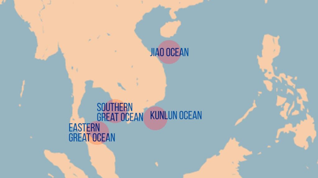
We have previously seen the Jiao, or Jiaozhi, Ocean. One ocean that Zhou Qufei does not mention but which we can find references to in various works is he Kunlun Ocean. That was a reference to the area around what is now Côn Đảo.
As for the Southern Great Ocean and the Eastern Great Ocean, the term that I am translating as “ocean” is “yanghai” 洋海, which literally means “ocean sea.” I haven’t come across these bodies of water mentioned in any other works.
The information about what is to the south of Sanfoqi and the East of Shepo blends into the mythical, indicating that mariners did not venture out into those waters.
If we follow my understanding that Sanfoqi was Kambuja, Shepo was somewhere around Lake Songkhla, and most ships still followed the coast, then this information makes perfect sense.
Again, everything was on a much smaller scale than we have assumed. And historically, that makes sense.
Taken together, the world of these oceans looked something like this:
As I said, I will get into details later (and already have done a lot in my publications), but the point of this blog post is to look at the larger geographical understanding of maritime Southeast Asia that we can see in the twelfth-century Lingwai daida.

You may want to read the description of gharuwood producing countries in the Zhufan zhi, for that defines countries according to upper coast (Zhenla and Zhancheng), and lower coast (Dashi, Sanfoqi, Shepo). The statement is at least in part validated by the earlier Lingwai daida statement that Shepo was on the lower coast, the idea being that the ocean surface inclined downwards in the vicinity.
Thanks! I’ve seen that before, but I’ll try to consolidate it all together.
Yea, before the digital age, I don’t think I would have thought to look through that second juan to find geographic information, but thanks to being able to search through documents. . . I’ve been delivered there a few times, and very happy that I was.
I’ve read some papers, I think from Roderich Ptak again, that suggests this Bosilan was Basilan in Sulu archipelago. If that was the case, this Cambodian polity of Zhenla and the Vietnamese Champa kingdoms vassalised Basilan and Butuan respectively during the Song Dynasty.
In Chinese sources, it is clear that there was a connection between Champa and Puduan/Butuan. I haven’t looked at Bosilan, but I will check.
I haven’t figured out how that happened or how that worked. There is one record which says that Butuan was “50 leagues” to the east of Champa (or something like that). That number is obviously wrong, if this was actually the place in what is now the Philippines.
It looks to me like, at least in the early Song period, the Cham played a big role in getting tributary trade moving from the region to China:
https://leminhkhaiblog.com/when-the-cham-ruled-the-seas/
I’m guessing that it might be the case that Cham mariners went down to the Philippines from Guangdong and brought goods up on behalf of Butuan.
Later, in the fourteenth century, Ibn Battuta went through the Straits of Melaka past Java to the southern Philippines and up to China. So, there could have been a “trade circle” there, but the Chinese world only interacted with the upper half, and hence, didn’t record information about the southern half.
I was wondering though, if Sanfoqi was indeed Cambodia, what are these “over ten thousand islands” in the Gulf of Thailand then? How was the thought process of the Chiense mariners at that time? Was that remark not supposed to be taken literally? Cuz besides some islands off the coast of southern Cambodia, the Gulf of Thailand is pretty clean… And looking at the map, it does make sense that the early Chinese mariners really would have looked at a ‘twisted axis’ view of the Gulf, with the Tennaserim peninsula blocking the Gulf at its northwest and the Malay Peninsula on the southwest…
“South of Sanfoqi is the Southern Great Ocean. In that sea are over ten thousand islands, where people live in settlements. But further south it is no longer passable.”