

Several years ago, I first suspected that a name that we find in Song-dynasty-era sources, Sanfoqi, referred to “Kambuja/Kampuchea” rather than what most of the rest of the scholarly world has always thought, which is that it referred to a polity called “Srivijaya” based at Palembang.
In testing this idea, I came across passages like this one in the History of the Song, which says of Sanfoqi that “it neighbored Zhancheng [Champa], and was situated between Zhenla and Shepo” (與占城為隣,居真臘、闍婆之間).
I believed (and still believe) that Sanfoqi and Zhenla were both in what is now Cambodia. However, as for Shepo, most scholars have argued that this is “Java,” because 1,000 years ago, the characters for “Shepo” would have been pronounced something like “Java,” or “Jaba.”
For my idea that Sanfoqi was in Cambodia, it would not make sense if a text said that it was between another place in Cambodia and Java, as that was too far away. So, I decided to check if people were really correct in thinking that Shepo was Java.
I found that the only detailed information about Shepo’s location came from the 1225 Treatise on the Various Barbarians (Zhufan zhi 諸蕃志) where it states the following:
東至海,水勢漸低,女人國在焉;愈東則尾閭之所泄,非復人世;泛海半月,至崑崙國。南至海三日程,泛海五日至大食國。西至海四十五日程,北至海四日程。
Eastward to the sea the water’s force gradually lessens; the Kingdom of Women [Nuren Guo 女人國] lies there. Further east is the place where the converging waters [weilu 尾閭] drain away — no longer the world of men.
Sailing the sea for half a month one reaches Kunlun Kingdom. Southward to the sea is a three-day journey; crossing the sea for five days one reaches Dashi Kingdom. Westward to the sea is a forty-five-day journey; northward to the sea is a four-day journey.
Putting aside the names for the moment, this passage seems to describe a place where the sea was close to the east and could be reached in the other three directions, with the south being the most direct route. Further, I had never seen a passage which talked about reaching the sea in all four directions (and now years later, I still have not seen a comparable passage). So, there is obviously something important about that detail.
In looking at this information, but also understanding that the numbers could be incorrect, the first thing I asked myself was a general and logical question, “Where in Southeast Asia is a place from which one can reach the sea in all four directions?” And perhaps even more importantly, “Where would it make sense to try to reach the sea in all four directions?”

The one and only place that I could think of, is the area around what is now Lake Songkhla in southern Thailand. To the east is the Gulf of Thailand, and across it at the end of the Indochinese Peninsula, is a place that is historically associated with the term “Kunlun,” mentioned above.
Heading more or less south from there one could reach Kedah, one of the places where ships from the Middle Eastern world (Dashi), along with the northern tip of Sumatra, not that far away.
Heading to the west would be a more arduous journey, but it appeared to be possible. And finally, it looked to me like one must have been able to navigate through the inland lakes in that area and along rivers to reach the sea to the north.
So, it was possible to reach the sea in all four directions, but would it have made sense to?
YES!!! DEFINITELY!!!
Why? Because this was a prime location for trans-peninsular trade routes. Ships from the Middle East, for instance, would have just had to land at Kedah, and then they could have consigned their goods to agents who transported them to Songkhla and then on to Sanfoqi/Kampuchea or on to Champa or China.
Further, if there were foreign traders who were rivals of people from the Middle East, those people could go to a place further north on the western side of the peninsula, and have their goods consigned to agents who would bring them over the western route, etc.
In such a world, whoever controlled the Lake Songkhla region would have had the potential to become immensely wealthy, and that appears to be precisely what happened, as Arabic accounts contain information about the incredible wealth of a place called Zabag (sounds like “Shepo/Jaba”), which appears to have been in this very location.
With all that wealth and that control, it would also be predictable that one would attract rivals, and it is precisely this area of Southeast Asia that the Chola Kingdom is documented to have attacked in the early eleventh century, with the greatest prize having been the conquest of a place called Srivijaya or Srivishaya, meaning something like “the royal district.”
That attack, I’ve argued elsewhere, appears to have taken place with the consent of Sanfoqi/Kampuchea, which Chinese sources claim was a major rival of Shepo’s, and not surprisingly, in the centuries that followed we see Angkor flourish as the main power in the region, and we also see evidence of a continued presence of people from South Asia as well.

While all of this is logical, and while I have found plenty of evidence to support this understanding of the past, the one type of information that I have not previously found is evidence of is of people actually traveling in those directions towards the sea from Songkhla.
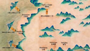
There are maps made by Europeans, such as one from the nineteenth century in the image above that shows routes in exactly the places where the Zhufan zhi would lead us to expect them to be, however I haven’t found textual information of people crossing those routes.
Recently, however, I revisited a text that I examined before, and this time I looked at it more closely. The text is an early-nineteenth-century Vietnamese work called the Collected Records of the Routes in the Kingdom of Siam (Xiêm La quốc lộ trình tạp lục 暹羅國路程集錄), and in the previous post, I discussed evidence for what we can think of as the Zhufan zhi northern route to the sea.
In this post, I would like to look at another passage in that text, and in this passage, we can see evidence of the western and southern routes mentioned in the Zhufan zhi.
㳥(鳥/仕)海門,門廣約五十尋,水深六尺,門之北山林叢茂,門之南沙渚以至海湄,江長一曲,至㳥(鳥/仕)茫,有昭茫官鎮守,兵約三千率,民居稠密,庯[i.e., 舖]市田疇。自㳥(鳥/仕)江長屈曲,兩傍林藪椰葉,民居田疇,江中有大小沙洲,相隔二區,水程二日至渃𠮾𤅶。此𤅶周包廣約,水程徑行一日,內有五行山,其山有燕巢所產,外周圍平地曠野茅葦,民居田園多象虎。自渃𠮾𤅶向西,有一派小江,江長屈曲,兩傍民居田疇,水程一曲至些聾茫。此茫有暹官鎮守,兵約二千率,民居稠密商賈。自些聾茫江長屈曲,以至源頭,山林茂盛。自渃𠮾𤅶向南,有一派小江,江長屈曲,兩傍吒巴[both of these characters have 囗 around them]民居林雜,水程三日以至上源。
自上源向西,曠野山林叢雜,陸行二日至茫冰醝。此茫吒巴官鎮守,兵約三千率,民居稠密,舖[i.e., 舖]市商賈。
The Sóng Sẻ [Songkhla] estuary is approximately fifty xun [fathoms] wide, with a water depth of six chi. To the north of the estuary, mountain forests are lush and dense; to the south, sandbars extend all the way to the seashore. The river bends once, reaching Sóng Sẻ Mương [Mueang Songkhla].
There is a Chiêu Muang [Chao mueang] guarding it, commanding approximately 3,000 troops. The population is dense, with shops, markets, and cultivated fields.
From the Sóng Sẻ [Songkhla] River, it winds for a long distance. On both banks are forests, thickets, and coconut leaves, along with dwellings and cultivated fields. In the middle of the river, there are large and small sandbars separating it into two regions. A water journey of two days leads to the Sweet Water Sea (Nước Ngọt biển).
This sea area is vast and encompassing; traversing it directly by water takes one day. Inside, there is the Five Element Mountain, which produces bird’s nests. The outside is surrounded by flat plains, wilderness, and reeds. The dwellings and fields are frequented by many elephants and tigers.
From the Sweet Water Sea heading west, there is a small river branch. The river is long and winding, with dwellings and fields on both sides. A water journey of one bend leads to Ta Lung Mương [Mueang Phatthalung].
This mương is garrisoned by a Siamese official, commanding approximately 2,000 troops. The population is dense with merchants. From Ta Lung Mương, the river winds for a long distance to its source, where mountain forests are lush.
From the Sweet Water Sea heading south, there is a small river branch. The river is long and winding. On both sides are the dwellings of Cha Ba people mixed with forests. A water journey of three days leads to the upper source.
From the upper source heading west, through wilderness and mixed mountain forests, a land journey of two days leads to Mương Băng Sai [Mueang Saiburi, in another text in this collection it is called Mương Sai].
This mương is garrisoned by a Cha Ba official, commanding approximately 3,000 troops. The population is dense, with shops, markets, and merchants.
So, there we have it! This passage begins with a description of reaching Songkhla from the sea in the east, then it mentions the routes to the sea to the west and to the south, and in the previous post, we saw the passage to the sea to the north.
Yes, I know, it doesn’t say what happens after one reaches the source of the river in the west, but the early-nineteenth-century map above shows a route in precisely this location going all the way to the western coast.
It is also COMPLETELY OBVIOUS that this is the place described in the Zhufan zhi. There is no other place in Southeast Asia that fits that description, nor any other place that has historical documentation like this to support it.

I also strongly suspect that the place called Srivijaya/Srivishaya that the Chola reportedly destroyed was in this area.
As for the place where the above text has Songkhla located, there are indeed the remains of a fort there, at what is now Khao Daeng. While the remains of that fort do not date to the thirteenth century, as far as I can tell, archaeologists have not examined that site enough to determine if it was built on top of an older fort from that earlier time period.
However, even if it wasn’t, it is also possible that whatever polity was controlling the trade that came across those trans-peninsular routes could have been somewhere else, such as inland on the southern route, perhaps in the area of what is now Hat Yai.
However, clearly there was such a place. Chinese sources document it, and Arabic accounts document it, and the above Vietnamese source makes it blazingly clear that this is where it must have been.
Your arguments are really sound, professor. I’m just quite confused with the Srivijaya the Cholas mentioned having been sacked though.
Just to clarify, this ‘Srivijaya’ is the one at Jaba/Songkhla area right? Cuz like, you said, 19th-20th century scholars were equating Sanfoqi with Palembang/Sumatran Srivijaya, and you’ve been arguing Sanfoqi was Kampuchea/Angkor, and that Zabaj/Zabag was one of the two Javas, and that Zabag = Jaba/Shepo/Songkhla, right?
However, scholars persist equating/conflating Sanfoqi with Palembang/Sumatran Srivijaya and that this Palembang Srivijaya was the one the Cholas attacked.
So you’re saying the Srivijaya the Cholas mentioned attacking was the one at Jaba/Songkhla, right?
***
I’ve been reading your arguments, and I can get quite confused sometimes cuz, of course, you’ve also been developing your arguments as you find new evidence and new ideas/interpretations pop up [as can be gleaned from your Srivijaya series].
So, in summary,
Sanfoqi = Kampuchea/Angkor.
Sanfoqi ≠ Srivijaya
Foshi ≠ Sumatran Srivijaya
Shilifoshi ≠ Srivijaya but Sri Bohja [?]
Sumatran Srivijaya does not refer to a kingdom/polity named Srivijaya, and that it could just possibly be a name of a certain king/a general word for a ‘royal district’ that was jotted down on Sumatran inscriptions.
Shepo/Zabag = Jaba/Songkhla polity.
The Chola Srivijaya = Jaba/Zabag/Shepo/Songkhla polity.
Am I correct?
I just find these really amazing as we can also see how the important trading sites continue to shift southwards from Kra Isthmus to Malacca Straits pre-Tang to Ming dynasties. I also find how potentially Malaysia/Thailand nationalism could be boosted using your arguments.
I suspect you are not the only person who is confused, so I just wrote this up. Perhaps it will help.
https://leminhkhaiblog.com/what-i-now-know-about-early-southeast-asia-in-chinese-sources/
Some minor points:
Sanfoqi = Angkor’s main international trade vassal. It was a place in Cambodia, inland from the southern coast, and probably near the Mekong and the Tonle Sap, and as part of the “mandala” empire of Angkor, it would have been one of its “vassals.”
Shilifoshi = Yes, that name should have indicated something like Sribhoja.
Sumatran Srivijaya – In my first article I said it might be the name of a king, but that is incorrect, and I corrected that in the second article.
That said, I don’t know what those inscriptions are describing. I leave that up to the epigraphers to decide. The inscriptions are spread from the Malay Peninsula to southern Sumatra, and everyone seems to place the “center” in Sumatra and the inscription in Thailand is at its far reaches. Personally, I don’t see why people don’t look at it the other way: the Lake Songkhla area was the center and southern Sumatra was an area that it tried to extend its influence to at one point.
But again, I leave that up to the epigraphers.
Yes, I think the potential for Thailand is huge. They should do some scanning of the whole greater lake area, and if they find stuff. . . Then think “Jaba Museum” and “overland river/hiking tours” that “cross the ancient routes of the Golden Age of Jaba”. . .
Malaysia has Langkasuka and the overland route from Pattani. . .
Thank you so much for responding, professor!
Some of these place names also appear in Đại Việt sử ký. Do these entries reflect direct borrowing from Chinese historiographical texts, or might they preserve some elements of a local tradition?
Thanks for the question!!
I wrote about that a few years ago: https://leminhkhaiblog.com/srivijaya-3-0-20-jaba-in-the-dai-viet-su-ky-toan-thu/
There is one record from before 1,000 AD. That represents a borrowing from Chinese texts. The references after that point are local tradition.
The interesting thing is that Chinese start using the character Zhuawa/Zhaowa 爪哇 to refer to the island of Java during the Yuan dynasty period (1271–1368), however, in the DVSKTT, those same characters appear earlier, but they seem to be referring to the place on the Malay Peninsula.
Here is an example:
己巳十年宋紹興十九年春二月,爪哇、路貉、暹羅三國商舶入海東,乞居住販賣,乃於海島等處立庄,名雲屯,買賣寳貨,上進方物。
Kỷ Tỵ, [Đại Định] năm thứ 10 [1149], (Tống Thiệu Hưng năm thứ 19). Mùa xuân, tháng 2, thuyền buôn ba nước Trảo Oa, Lộ Lạc, Xiêm La vào hải Đông6, xin cư trú buôn bán, bèn cho lập trang ở nơi hải đảo, gọi là Vân Đồn, để mua bán hàng hoá quý, dâng tiến sản vật địa phương.
“In the spring, in the second month of the tenth year Kỷ Tỵ,the nineteenth year of the Song Shaoxing reign period [1149], merchant ships from the three kingdoms of Trảo Oa, Lộ Lạc [Hạc], and Xiêm La entered the eastern sea, requesting permission to reside and trade. They thereupon established a trading station at places in the sea islands, called Vân Đồn, where they bought and sold precious goods and presented local products as tribute.”
Again, these are the characters that would later be used by the Chinese for the island of Java, but people from that place arrive together with people from Xiêm La [Siam] and Lộ Hạc [probably Longvek].
Given everything I’ve been able to determine about the trade world at that time, the area around the upper part of the Gulf of Thailand was a “interaction zone,” and therefore, it would make more sense that this “Java” was the one from there, rather than the far away island of Java.
Then, however, there is a 1349 record that mentions the kingdom of Đại Oa 大哇國 or “Great Oa.” Now that could be referring to the island of Java, as there are references in Chinese sources around this time for a Da Shepo 大闍婆 that refers to a kingdom on the island of Java.
Meanwhile, in 1348, there is a record of a Chà Bồ 闍蒲 or Shepu in Chinese.
So, in Vietnamese sources, I think we can see the “two Javas,” with island Java appearing in the DVSKTT around the same time that it does in Chinese sources, but the characters that the Vietnamese used to transcribe those names do not follow a clear trajectory like they do in Chinese from Shepo to Zhuawa/Zhaowa.