Having shared the translations of some of the information in Arabic texts about Southeast Asia in the last post, let’s take a look at what they have to say about the place called Jāba/Zābaj, which I argue was a trans-peninsular trading empire that was based at Songkhla in what is now southern Thailand.
To being, let’s first just try to get a basic sense of what key places were mentioned in some of the early texts and how these places were positioned in relation to each other.
Akhbār al- Ṣīn wa’l-Hind (c. 850)
Langabālūs – Kalāh-bār – Tiyūma (10 days from Kalāh, as fresh water)- Kadrang (has fresh water springs, and is described as “a high mountain where slaves and robbers sometimes hide”; 10 days from Tiyūma) – Ṣanf (Champa, 10 days from Kadrang).
Also mentions an island called Rāmnī, but doesn’t indicate where it was in relation to other places.
Ibn Khurdādhbih (c. 850)
Alankabālūs – Kilah (= Kalāh; 6 days) – Jāba/Salāhiṭ/Harang (2 parasangs) – Mā’iṭ (close by) – Tiyūma (not far) – Qmār (Cambodia; 5 days) – Ṣanf (3 days)
Ya’qūbī (d. 897)
Kalāh-bār – a sea called Salāhiṭ – a sea called Kadrang
Ibn Rusta (c. 900)
Kalāh – Zābaj – Zanj / “East Africa” (typo for Ṣanf / Champa)
Tibbetts translations a part of this text as follows: “In passing by Zābaj in order to reach Zanj (East Africa) one must pass through the region of darkness, where the sun only appears for six hours in the day.” (31)
There are other passages in this text where the term “Zanj,” a term for an area of East Africa, appears. Ferrand translates those passages, and it is clear from the context that this is not referring to East Africa, but instead, to Ṣanf / Champa (see pages 68-9).
This text also mentions, in a different section, that one reaches Harang after Salāhiṭ and that these were both territories of the Maharāja.
Abū Zaid (916)
Says that among the possessions of the Maharāja of Zābaj are “the island called Sribuza of which they say the area is four hundred parasangs and the island called Rāmi [i.e., Rāmnī] which is 800 parasangs in area.” (33)
Although some of these texts are more detailed than others, I think that it is easy to see a general pattern in these works.
First, I think we can identify a trans-peninsular route that went as follows:
Langabālūs / Alankabālūs = Nicobar Islands (or somewhere around there)
Kalāh/Kalāh-bār/Kilah = Kedah
Jāba/Zābaj = Songkhla
Salāhiṭ = Sathing Phra
Harang = Patthalung
Mā’iṭ = Ko Mak?
Tiyūma = Talumphuk
Kadrang = This also appears as “Kundrang,” and is a reference to Côn Đảo/Kunlun Island/Pulo Condore, known at that time in Chinese sources as Mount Juntunong 軍突弄山.

Ok, so Kalāh sounds kind of like Kedah, and one can see how Kadrang/Kundrang could be the same as Mount Juntunong when we consider that Chinese doesn’t have the consonant cluster “dr” and 1,000 years ago this could have been pronounced as something like “kun-dwət-ləng” (according to Pulleyblank’s reconstructions).
However, why can’t we say the same for the places in between?
Songkhla, Sathing Phra, Patthalung, Ko Mak, and Talumphuk are all Thai names for places that were originally inhabited by people who did not speak Thai. This is a region that was probably inhabited early on by Mon-speaking peoples (“ko” in the name “Ko Mak,” for instance, is the Mon-Khmer word for “island”), and then at some point, you had people who speak Austronesian languages, like forms of Malay, move into the area.
Thai-speaking peoples were the last to arrive in this region, and they did so long after these Arabic accounts were created. Therefore, we should not expect there to be a “direct match” between the names in Arabic and the current Thai-ified placenames. This is especially the case when we also consider that the names that were recorded in Arabic texts were undoubtedly not exact reproductions of how those names were pronounced by local people, but instead, were Arabic-ified.
Further, the term “Jāba/Zābaj,” was used in Arabic sources to refer to the various “islands” that the Maharāja of Jāba/Zābaj controlled, and it could also refer to his “capital,” which I believe was located somewhere around where Songkhla is today. That said, I doubt that this is what the people there actually called that place, and as such, I doubt that there is a linguistic connection between “Songkhla” and “Jāba/Zābaj,” just as later there would be no linguistic connection between the name “Ayutthaya” and the way that foreigners called it, “Siam.”
However, I can see vague linguistic connections between the following terms: Salāhiṭ/Sathing Phra, Harang/Patthalung, Mā’iṭ/(Ko = island) Mak, and Tiyūma/Talumphuk. And again, given that we are comparing Arabic-ified versions of placenames with Thai-ified versions of placenames, vague linguistic connections are probably the most we can hope to find.
What we can then do to gain a clearer sense of what the placenames in Arabic texts referred to is to look at the geographic descriptions and information about these places in those texts.

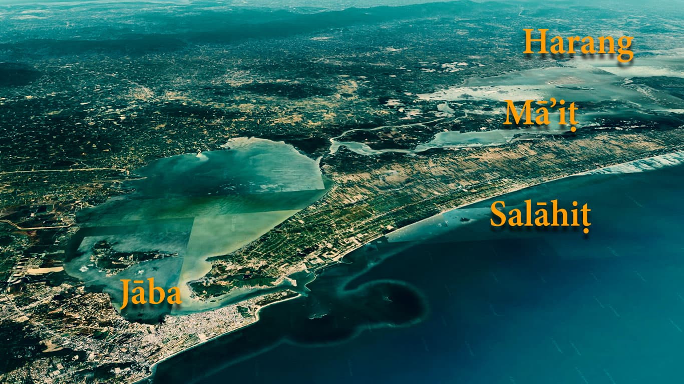
Jāba/Zābaj, Salāhiṭ, and Harang are mentioned together, and Mā’iṭ is close by.
If you look at the above map of the Songkhla area, you can see that there is a big lake called Songkhla Lake. It is called Thale Sap Songkhla in Thai, and “thale” is a Mon-Khmer word for a body of water.
Songkhla is located at the southeastern corner of the lake where there is a strategic opening to the sea, and Patthalung is located on the western side of the larger section of the lake.
To the east is a strip of land that separates the lake from the sea. This is called Sathing Phra and in the early 1980s, archaeologist Janice Stargardt did work here and found that there is evidence that there used to be canals that went across Sathing Phra and connected Songkhla Lake with the sea.
Then in the middle of Songkhla Lake are two islands. One is called Ko Nang Kham. This has meaning in Thai, and it means “the island of Lady Kham.” I don’t know who Lady Kham was, but obviously, there must be a story behind that name, and given that the name is in Thai, I’m guessing that this is a later Thai story rather than an early story created by the indigenous or early inhabitants of this region.
The other island is called Ko Mak, and “mak” here is the Thai word for “many.” This doesn’t make sense. It doesn’t mean “many islands” because Ko Mak is just one big island. It also shouldn’t mean “big” because the Thai word for “big” (yai) is used in the names of islands. My guess would be that this is a Thai-ification of an earlier name, such as whatever the name was that Arabic sources refer to as “Mā’iṭ.”
[And here it is probably worth noting for people who don’t know Thai that the final “k” in “mak” doesn’t really get pronounced, and this word, therefore, sounds more like “maa” with a swallowed “k” at the end. I don’t know Arabic, but from that transcription, it looks like it is pronounced as “maa” with a short “t” at the end.]
So, when we consider that there are four placenames of places that are close together that get mentioned in Arabic sources after Kedah (Jāba-Zābaj / Salāhiṭ / Harang / Mā’iṭ), and we then look at the geography of where people would have gone if they traveled across the Malay Peninsula from Kedah and find that there are four places that logically could be viewed together (Songkhla / Sathing Phra / Patthalung / Ko Mak), then I think we start to get stronger evidence for the correspondence between these terms than the vague linguistic connections allow us to make.

Let’s now look at some more details. Various accounts mention a “volcano” near Jāba/Zābaj. This has led scholars to conclude that Jāba/Zābaj must have been located on the island of Sumatra because there are no active volcanoes on the Malay Peninsula.
Ok, but let’s look at what the Arabic texts actually record.
Akhbār al- Ṣīn wa’l-Hind (c. 850)
They say that near Zābaj is a mountain called the Mountain of Fire, which it is not possible to approach. Smoke escapes from it by day and a flame by night, and from its foot comes forth a spring of cold fresh water and a spring of hot fresh water. (27)
Ibn Khurdādhbih (c. 850)
There is in Jaba a small mountain with fire on its summit stretching for the distance of a hundred cubits but having only the height of a lance. One sees its flames at night but only smoke during the day. (29)
Mas’ūdī (d. 956)
The volcano of Zābaj is in the sea of China. (39)
Dimashqī (d. 1327)
The island of the Maharāja is very large, its length being twelve days [march] and its width five. At its extremity is situated a large volcano, which throws cinders like stones, with the noise of thunder and lightning. Because of the fire near it, there is neither habitation nor road for the distance of a parasang. This volcano is the largest in the world, there is nothing like it. The place which it occupies is called the Isle of the Volcano, and compared with the rest of the island, it is like the foot compared to the limb. (62)
So, in the ninth and tenth centuries, there was mention in Arabic sources of a “small mountain” that had a fire on its summit, and that it was in the “sea of China,” meaning on the eastern side of the Malay Peninsula.
Then in the fourteenth century, you get an account of what clearly appears to be an active volcano. How can we explain this information?
Let’s start with the fourteenth-century account of a volcano. The reference to “the island of the Maharāja” is vague in that these texts sometimes referred to “the island” of the Maharāja and at other times stated that he ruled over many islands. The statement that “its length being twelve days [march] and its width five,” is also vague.
Tibbets inserted the word “march,” indicating that this was an explanation of walking distance, however in these texts, “days” are usually an indicator of sailing distance (and do we really think that Arab mariners walked for 12 days across land?).
If we think of the Maharāja’s empire as taking 12 days to sail across from east to west, and five from north to south, then that would perhaps be an accurate description of the area stretching from Songkhla and Patthalung across the Malay Peninsula to include parts of Sumatra as well as Kedah. And sure enough, at the extremity of that empire, one could have found an active volcano, such as Bur ni Telong in northern Sumatra.

As for the small mountain with a fire on its summit that only burned at night, I think we can make a case that this was a mountain in Patthalung called Khao Ok Thalu.
This mountain is a defining feature of the region, and today is the symbol of Patthalung Province. So, why would there be a fire on top at night?
I would like to posit that fires were intentionally set there at night to direct ships towards Jāba/Zābaj, Salāhiṭ, Harang, and Mā’iṭ. Khao Ok Thalu is visible from far out at sea, and if one lit a fire there at night, this would have enabled ships at night to identify where Jāba/Zābaj was.
In a world where polities on the eastern side of the Malay Peninsula controlled trans-peninsular trade routes, there must have been competition between these polities, and Jāba/Zābaj could have gotten the upper hand by operating a premodern “lighthouse.”
One obvious way to check this theory is to send a geologist up to the peak of Khao Ok Thalu to test the ground for any evidence of burnt sediments from 1000+ years ago.
Given the way that this small “mountain of fire” is described, this is the only logical guess that I can make, because the accounts clearly do not seem to be describing an actual volcano.

Another feature of Jāba/Zābaj that is mentioned concerns a place where fresh water and sea water meet. This was reported in detail by Abū Zaid (916). In talking about a former Maharāja, he stated the following:
“His palace faced onto a talaj which emanates from the sea; one means by talaj an estuary resembling those which the Tigris forms when it passes by Baghdad and Basra, an estuary which the salt water of the sea invades at high tide and which is fresh at low tide. This water formed a small lagoon adjoining the palace of the king.” (33)
The foreign word that Abū Zaid mentions here, “talaj,” is strikingly similar to the Mon-Khmer word for a body of water, “thale.” That term is used today in the name of the body of water that the city of Songkhla sits next to, Thalai Songkhla, a body of water that has a narrow outlet to the sea.
I think it is safe to say that we have a “perfect match” here.
Finally, Idrīsī (d. 1165) says of Harang, the place that I believe corresponds to what is now Patthalung, that “There exists in the island of Harang a great abyss, of which no one has been able to reach the bottom. This is a remarkable wonder.” (53)
Do a YouTube search for “Patthalung cave” and you can find this remarkable wonder.

In conclusion, even though the Arabic texts that contain information about Southeast Asia have limitations, I think we can nonetheless get a sense of the places they referred to, and we can definitely see the trans-peninsular trading empire of Jāba/Zābaj with its base at Songkhla.
We can also get a sense of other places, such as the tributaries of Jāba/Zābaj on the island of Sumatra, and that is a topic which we will examine next.


The “abyss” might well be a blue hole, but has been understood in the Brunei context as Mt Kinabalu (with Harang as Brunei) which would put Mait in the southern Philippines (discussion of which would certainly open another can of worms). There is a chance that the Mait in the 10th century is the Mayidong referred to by Fei Xin in the 15th century.
Thanks for mentioning this. I’ve seen mention of Brunei, but I have never followed up on that. Is there one person in particular who promoted that idea? If so, who was it?
Robert Nicholl started this idea in an article published in 1983 in JSEAS and it has since been taken up by local Brunei writers, bloggers, and wikipedia enthusiasts.
Ok, thanks!! Yes, I’m curious to see how he made his case.
Ma-i in chinese records was just Ba-i, same character in Chinese writing system.
North of Bo-ni is the island of Ba-i (Laguna de Ba-i near Tundun/Manila)
There are 2 volcano in Luzon, aone in Pinatubo facing south China Sea through San Marcelino River.
I finally finished reading the Sanfoqi published so far. Very interesting, hope there are more scholars look at it. BTW: forgive my Khmer-centric but a lot of these place names, that you found dizzling, are easily solved by looking at them as Khmer rather than Thai.
____
Sathing Phra: Stung Preah. Sacred Stream/River. Easy.
Songkhla: Sangha (monk) or Song (build), Khla (tiger), “Tigerlike monk” or “build a tiger”.
Patthalung: lung (sink in water), Pattha (?) : Preah (God) Tha (Said),: “God/Buddha/Goddess Said Sink” (folk story somewhere).
Ko Nang Kham: Koh Neang Kham : “Island of Biting Lady”. Neang (lady) Kham (Bite) or Khom (Khmer). (easy)
Talumphuk: Talum (? = Plum blow), Phuk (Mud?), “Muddy Talum?”.
Ko Mak/Ko Ma’it: if Ko Maa = Koh Mat/Miat (Size), then it is easy to say “Fat Island” in Khmer. If it is Ko Maa, it could meant “Uncle Island”
_____
That’s it. The Khmers were there, so these are Khmer names.
Pattha could come from “bro-teal” meaning “herb”. Talum, maybe a type of tree or plant, who know. That’s just my Occam Razor approach. Just more evidences for the Khmers in this areas and more proof that Sanfoqi is Cambodia. Chaiya (Jaya) and Nakhorn SiThamararat, (Nagara Sri Dharmaraja) are Pali/Sanskrit names could apply to anything, but Ko Nang Kham and Sathing Phra, there is no doubt they are Khmer.
Me again, folk etymology, might just be bad etymology, may somebody else described it more accurately, but seeing this Khmer.
Sathing Phra: ស្ទឺងព្រះ
Patthalungៈ លុង or ធ្លុង (I hate Unicode in not making it four lines) Thlung meaning fishing trap with a hole. (probaly refered to that cave). Phatha may be Indian for “split wood”
Ko Nang Kham: កោះ នាង ខាំ (biting lady, probably because of that crescent-like mouth-like mountain I see on Google when google this place). Another meaning for ខាំ is frugal or patience.
Ko Mak: could be Hokkienese for Mother. កោះ ម៉ាក់ (Mother Island) Ko Mait: កោះមាឌ្ (Sizable Island), Ko Maa កោះមា (uncle Island) or កោះមារ (enemy island)
Talumphuk: ធ្លំភុក sound Khmer.
Sangkla សង្ឃខ្លា or សង់ខ្លា but if it came from Malay Singora then it could derived from សិង្ហ (lion) sth. or ស៍ង្ខ (couch). The Malay Sing Gora could get it from Khmer word Singha Krab សិង្ហក្រាប (Crouching Lion) or Gora may come from anything else.
I don’t know how accurate all these is. But it sound Khmer Toponyms to me just like the Mekong Delta and the Khorat plateau.
Thank you for sharing these ideas.
The area around Lake Songkhla seems to be right where the Mon-Khmer and Austronesian worlds meet, so that makes it very difficult to figure out origins of names.
While there is evidence (inscriptions in Old Khmer) of Khmer administrators in the area of what is now Nakhon Si Thammarat, I haven’t seen any historical evidence of any Khmer presence further south, let alone Khmer communities. That said, much of this area was probably inhabited by Mon-Khmer speakers.
So, take Lake Songkha. That is now called in Thai, “thale sap” Songkhla, which in Khmer would be “tonle sap” Songkhla. The modern tonle comes from old Khmer:
danle ~ danley /dənˈleː/. [Pre-A. danle ~ danley; mod. ទេន danle /tʊənˈleː/ “n.
(large) river”; perhaps ‘that which turns or winds’, ifx /-əɴ/ + *dhle /tʰleː/]. 1.
n. Major river, large waterway. 2. n. Large body of water: pond, pool, tank,
reservoir, lake, sea.
I don’t know anything about Mon, perhaps it’s in Old Mon too.
So, given the fact that there might have been Mon-Khmer speakers that far south (or close to that far south), does that term, “tale/tonle sap,” predate the use of it by the Thai? I don’t think that there is any way to know for sure.
One thing that is desperately needed is really good linguistic studies of Pattani and Kelantan Malay. Those northern versions of Malay are very distinct, and definitely reveal significant linguistic mixing, but I have yet to see a really solid and detailed study of those languages.
Having said all that, the idea that Sathing Pra might come from Stung Preah is interesting, because one of the landmarks of “Shepo/Jaba” was a place where the water flowed into the sea. The Maharaja had a canal of gold made there (or something like that). This is recorded in Arabic sources.
It was brought to my attention that Sating Pra being Stung Preah came from Vickery: in his 2003 “Funan Reviewed: Deconstructing the Ancients” paper back about the debate of the ethnicity of Funan was much more challenged during the time where academic papers are analog.
In the footnote, he wrote. “95. The equivalent Mon terms are kron (‘river’) kyiik (‘sacred, lord’). ” I don’t know Mon to comment.
Then, the specialists of Burma and Thailand believed Funan to be Mons, while the specialists of Malaysia and Indonesia believed to be Malays, and specialists of Cambodia believed it to be Khmer. The language and cosmopolitanism of the port polities are really something.
Thanks for pointing this out.
I wrote a post a few years ago about some terms in the “Shepo language”
https://leminhkhaiblog.com/srivijaya-3-0-21-the-language-of-jaba-i-cant-figure-it-out/
There were some terms there that I couldn’t figure out. Today I came across that same passage in a different text, with some variations that made this passage clearer.
闍婆國方言謂真珠為沒爹蝦囉,謂牙為家凌,謂玳瑁為家囉,謂香為崑燉盧麻,謂犀為低密云。
“In the local language of Shepo, pearls are called modiexialuo 沒爹蝦羅 [Old Malay/Javanese, Mutiara, from Sanskrit], ivory is called jialing 家凌 [Old Malay/Javanese: gading], tortoise shell is called jialuo 家囉 [Old Malay, karah, in pĕnyu karah, tortoise-shell turtle], incense is called kundunluma 崑燉盧麻 [from Sanskrit, kunduru, frankincense] and rhinoceros is called dimi 低密.
The one term that remains a mystery to me is “dimi” for rhinoceros. The only term close that I have been able to find is in Austroasiatic languages on the mainland, like Bahnaric, which has “rmiːh.” However, this term does not seem to be present in the Aslian languages on the Malay Peninsula.
Howdy, another thought provoking piece. A couple of notes.
To me “the small mountain with a fire on its summit” suggests a hill in the town khao Tangkuan if it means a pre modern lighthouse guiding the boats entering the inland sea. Also the old town patalung is believed to sit on the lakefront, while the present city centre sits some ten kms inland, so Khao Ok Thalu may be too far away?
J Stargardt says Sating of Satingpra is derived from Khmer word sretting. She reckons a third of everyday vocabulary of the Thai used in the area is Mon-Khmer origin. So it’s possible but we don’t know how long Satingpra itself is used. Chating pra is the name of the district where she placed the palace, for example. And the whole Satingpra was called as such until 1961 according to the wiki. Apparently Jatingpra was also used. At least we can say Sating is fairly modern and may offer very little in our seach of the ancient place names.
Thanks for these comments!!
Tangkuan sounds like a better option. There is also a passage somewhere (the Zhufan zhi maybe) which says that the king of Shepo would ascend a mountain to look out at the sea. I always thought that this might refer to a place like Tangkuan. That some form of lighthouse would be there would also make sense.
One thing I’m not clear about, however, is how much the coast may or may not have changed over time. Would Tangkuan have been connected to the land 1,000 years ago? Or would that have been an island and Rai Puang Thong have been the closest mountain?
As for Mon-Khmer words in Southern Thai, I came across one study, but I only have access to a snippet of it. Before I looked at it, I was about to agree with you regarding Sathing Phra, but this author argues that the Jathing is still the Mon-Khmer “steung.”
http://sealang.net/sala/archives/pdf4/karavi1996khmer.pdf
This is the citation:
Karavi, Premin. 1996. “Khmer Loanwords: the Linguistics Alien Fossilized in the Southern Thai Dialect.” In The Fourth International Symposium on Language and Linguistics, Thailand, 1037-1050. Institute of Language and Culture for Rural Development, Mahidol University.
That led me to look further and it turns out that this author has an entire dissertation on “Khmer Loanwords in Southern Thai Dialects” (เปรมินทร์ คาระวี คำยืมภาษาเขมรในภาษาไทยถิ่นใต้). It’s available here (in Thai): https://digital.car.chula.ac.th/chulaetd/
I will paste the abstract below, but thank you for pointing to another rabbit hole that I will now have to descend into. Looks like I now have plans for the weekend. . . 🙂
The purpose of this dissertation is to collect Khmer loanwords in the Southern Thai dialect (STD) and analyze their transforming processes into the STD, to compare the sounds and meanings between the Khmer loanwords and the related modern and ancient Khmer words, to compare the transforming processes of the Khmer loanwords in the STD to those of the Khmer loanwords in Standard Thai (ST), and finally to analyze key probabilities of when and how the Khmer loanwords entered into the STD. The results of this research show that there are 1,320 Khmer loanwords in the STD, 573 of which have their related loanwords in ST, while 394 occur only in the STD. When comparing the related sounds in the Khmer loanwords in the STD with modern Khmer words, 10 types of transforming processes form Khmer words into the STD have been found. Some of the sounds constituting words, especially the initial consonants, were weakened in most of the Khmer loanwords in the STD, while in ST, the sounds constituting words were completely borrowed. When comparing the Khmer loanwords in the STD with the modern and ancient Khmer words, it has been found that certain initial consonants, vowels, or final consonants in the Khmer loanwords are related to various sounds in related Khmer words. These sounds are more similar to those in ancient Khmer words than in the modern ones. Such sounds can therefore be used as the criteria in presuming the borrowing epochs of the Khmer loanwords in the STD ; 306 of the Khmer loanwords were borrowed from the ancient Khmer, 81 of these were borrowed from the modern Khmer, while the borrowing dates of the remaining cannot be accurately fixed. And with regard to word meanings, most Khmer loanwords and their related ancient and modern Khmer words are semantically similar, while a minority of Khmer loanwords show five types of semantic differences. The dissertation also indicates some ways in which the Khmer loanwords entered into the STD ; it has been found that there is a tendency that the majority of them were borrowed by adopting the sounds as perceived by Southern Thai speakers, while the remaining 57 words were adopted through the Khmer graphic forms.
Howdy sir, very interesting.
First, geological changes in the area. While satimgpra peninsula and its northern coast to pak phang seem a fairly modern creation, tidal flats, some study puts it around 1000bp. The southern side of the lake seems older. Pra cedi luang at the top of Tangkuan hill is said to be older than 1000 years. There’s a 19th century modern lighthouse on the hill as if to point out the importance of the location in guiding ships . This and the one on top of Khao Daeng on the other side of the lake’s entry would have been significant navigational landmarks.
Yes taking into account all the geologic movements is essential, especially around the area we are talking about.
I believe you read Brian Colless attempting to locate satingpra in the Chinese documents. Also, have you read looked Jane allen’s review on Stargardt’s work? Allen doesn’t believe Satingpra is that old, not as grand as Stargardt claims. She also disputes some of the alleged Mon Khmer connections.
As Colless notes the historical port settlements on the east coast stand almost equidistant from each other. From Chumpon down Chaiya, Ligor, Satingpra, Patani etc, do you think this as a result of development of navigational skills, superseding smaller ports, or is it some kind of design? I am intrigued because, out of all these east coast ports, Satingpra is artificially set up. There’s no natural river on the peninsula, no harbour or bay. Klongs are all man made. The settlement was unique, as it was a massive engineering project to turn the lake into a safe harbour.
Anyway have a good weekend.
Hi, I am the previous “Anonymous” with all the 4 comments before yours in this page, and other recent comments in prof. Kelly blog.
________
>As Colless notes the historical port settlements on the east coast stand almost equidistant from each other. From Chumpon down Chaiya, Ligor, Satingpra, Patani etc, do you think this as a result of development of navigational skills, superseding smaller ports, or is it some kind of design?
___________
For this, it sounded similar to Ancient Khmer Highways with the Dharmasilas being rest-houses at average distance from each other. Artificial canals being man-made, acting as highways of the city was seen in Oc Eo in the Funan era (500 BCE-500CE). The Khmer grid city design can give an artificially-setup appearance, having no natural river and artificial canals, are very much characteristics of urban cities of Sambor Prei Kuk (pre-Angkorian) and Banteay Chhmar.
_____
On Allen and Stargardt
_____
>Allen doesn’t believe Satingpra is that old, not as grand as Stargardt claims. She also disputes some of the alleged Mon Khmer connections.
_
Oc Eo was once a great port city in the ancient world. By the seventh century, it is much less population. In the modern era, it was a village. Sating Pra could have been the same thing. At one point time, it may be grand. At the another point, they are empty. The 14th century population decline coincided well with other cities in Angkorian and Bagan networks.
__
For Mon-Khmer connection, I don’t think these two have much of an idea at least in 1989. They were working on Coedes synthesis and other researchers who followed Coedes. Stargardt was criticized by Vickery in 2003 in which she cited “The Mons of Sattingpra” erroneously from Vickery “evidences of Mon-Khmer in the region”, not knowing the difference between Mon and Khmer language. This cultural part of of Allen reviews’ seem to suggest a homogeneous blob of “Mons doing things this way, Khmers doing things that way, Malays are more toward this” and plenty of the older academics who thought the same. They also thought of Dvaravati being one large Mon-speaking state. The ancient polities in this region was much more de-centralized.
Howdy, thanks for the comments Cricky.
As for the geomorphology of the Nakhon coastal plane, there’s a study by Umetsu et al., “タイ南部ナコンシタマラート海岸平野における砂州の形成と発達 Geomorphic Development of the Nakhon Si Thammarat Coastal Plain, Southern Thailand“ (2022, in japanese). As recent as 1000 bp there seems a boggy wetlands that separates the island of tantalam from the mainland.
As for Satingpra,
Coastal Evolution of Satingpra Peninsula, Songkhla Province:
Implications for Understanding Songkla Lagoon Formation
Araf Laerosa et al. 2024
> For this, it sounded similar to Ancient Khmer Highways with the Dharmasilas being rest-houses at average distance from each other.
I started to think Patthalung was accessed through this waterway first. Patthalung, or Talung was on the coast, halway point between Ligor and Patani. For some reason, most likely the silting up the strait of tantalam, then efforts were made to keep this route open by building klong.
The other effort to keep Talung connected to the sea, may have been the establishment of Satingpra? Or there could have been access to the ocean if the formation of the peninsula was relatively recent.
> Sating Pra could have been the same thing. At one point time, it may be grand. At the another point, they are empty.
Definitely, as Stargardt suggests, the first settlement of the peninsula was around today’s Ranod area, about 80km from present day Songkhla. Wat Utapao may have served as a gateway to the inland sea, to Patalung. One of various names anoted to a landmass known as Tantalam, was Talung lem (eg 1835 Reduzirte ka)suggesting some connection with Talung? The settlement moved to today’s Chatingpra area, some fifty km from Songkhla. We don’t know what it was called then, some scholars call “old” Singora ( on Tantalem island), eg Takakuwa in 1912, this supposedly went to decline in the mid 14th century. When the sultanate was established in the early 17th, the fortified palace was at the foot of Khao Daeng hill, which was demolished by invading Ayutthaya forces in 1685. The settlement is said to have then moved to Laem Son, the southern side of the Khao Daeng hill, then across the lake to the current “old town” at Bo Yang in the 19th. That official narrative suggests current Songkhla on the southern side of the lake goes back only to tha late 18th century.
However, looking at the western maps from 17th century, Sangora was placed on the southern side of the lake, not on the island of Tantalam.
As stated in “Reappraising the Narrative of Dato Mogul and Singora’s
Early History” (Benjamin J.Q. Khoo and Graham H. Dalrymple, 2023) “establishment of Singora preceded the arrival of Dato Mogul. The fourth fleet of Van Neck had set sail for Patani, when it first called at the“small city” of
Singora en route on 27 October 1601”.
The authors don’t specify where this “small city” of Singora Van Neck called in 1601, was it on the peninsula where Dato Mogul set up a fortress Singora, or on the other side of the lake Bo yang area, as portrayed on the western maps? Were there two city centres, one for trade and commerce and the other more administrative? What happened to this Singora in Bo Yang, when the Khao Daeng was demolished by the Thais?
When I was looking at the sun setting behind khao daeng, it occurred to me, this may be another possibility for decoding the burning hills. I took a few photos and showed them to a few friends. They all commented the photos look like a bushfire. Could some of those “burning mountains “, mean the western hills, where the sun sets? Or that’s too stretched?
Thanks for the comment. That’s a cool observation.
However, the account mentions smoke. My guess now, is that it could be a reference to Barren Island in the Andamans. The above text says that it’s “near” Zabag, and passing a volcano in the Andamans while traveling from the Middle East would fit that description. There is information in a Chinese source about that which I talk about at the bottom of this post:
https://leminhkhaiblog.com/the-surat-thani-phang-nga-crossing-in-the-third-fourth-centuries/
Good day guys
I found this article mentioned about Zabag.
One of known history about Zabag in arab book was relation with Khmer.
Prince Khmer head was cut off by King Zabag.
From thats history
We want to know where is location of Zabag.
Base on arab source and inscriptions.
Zabag island length or circumference is 400 farsakh
Farsakh is measure of distance in Arab and Persia
1 farsakh = 5 km by foot or 8 km by ship
So, 400 farsakh = 3200 km
Rumni island 800 farsakh = 6400 km
Then we know location Zabagz if we can answer this question :
1. So, what island in Asia has a circumference of 3200 km and 6400 km ?
2. Which region in Asia has an inscription about relation with Khmer kingdom in 9th century?
Thank you for the comment, Adi!!
Yes, I’m aware of the things you mention here. In the end, however, it is very difficult to use the distances in Arabic texts, because different texts have different distances, the term “island” can indicate a “coast,” etc.
The one thing we can see without trying to rely on unreliable distances is that a place called “Zabag” had a conflict with a place in Arabic texts referred to as “Qmar” (Khmer).
So, the way I look at this is to try to see if there is any similar evidence in sources in other languages. As it turns out, there is such evidence in Chinese sources.
Through many writings, I’ve argued that Zabag was the same as what the Chinese referred to as Shepo (pronounced something like “Jaba” in Chinese 1,000 years ago).
What I’ve argued in many writings is that Zabag/Jaba was somewhere around what is now Songkhla, on the eastern side of the Malay Peninsula.
The most detailed account of Zabag in an Arabic source comes from one that was written at a time when Arab ships were not allowed to go all the way to China. In that account, the author talks about the area of Zabag. I think it is in that work that the story of the conflict with the Khmer is recorded (or maybe it’s repeated there, I can’t remember off the top of my head – it does appear in more than one Arabic source though).
In any case, I don’t think it’s a coincidence that the most detailed account of Zabag in an Arabic source comes from one when the author was “stuck” in Kedah, he place that was at one end of a trans-peninsular trade route that passed over to places like Songkhla. He might have taken advantage of that time to travel across the peninsula, or simply talked to people who did so.
We know from Chinese sources that Jaba and a place called “Sanfoqi” were big rivals. Again, in many writings I have argued that Sanfoqi was “Kambuja,” that is, “Cambodia,” the place where the “Khmer” were.
In particular, I think it was the coastal area around what is now Ha Tien that was a big rival with Jaba, because both were in strategic places along the trade routes through the region.
With all of that in mind, I argue that Zabag was somewhere on the Malay Peninsula, and at the moment, I think the area around Songkhla is the most likely place, and that following Chinese and Arabic sources, it was in a rivalry with the Cambodian area across the Gulf of Thailand, around what is now Ha Tien.