
One of the first papers I ever published was called “Thoughts on a Chinese Diaspora: The Case of the Mạcs of Hà Tien” (2000). I wrote it as a final paper in a graduate seminar on diasporas in world history.
The paper was about a group of Chinese refugees, under the authority of a leader surnamed Mo (Chn.) or Mạc (Viet.). These refugees fled the Qing conquest of the Ming empire in the second half of the seventeenth century and established a base in the area of what is now the city of Hà Tien near the Cambodia-Vietnam border.
In the seventeenth century, this was also a kind of border area between territories claimed by the Cambodian king and the Nguyễn lords who were expanding their rule southward into the lower Mekong region, where another group of Chinese refugees established themselves at what is now Saigon.
When I wrote that article, I remember thinking how strange it was that places like Hà Tiên and Saigon were “open land” that was available for settlement. Those two places occupy prime locations for engaging in international trade. So, how could it be that it was only in the seventeenth century that people realized this?
Since I published that article, there have been major studies conducted on Hà Tiên by historians Claudine Ang (Statecraft on the Margins: Drama, Poetry, and the Civilizing Mission in Eighteenth-Century Vietnam) and Xing Hang (The Port: Hà Tiên and the Mo Clan in Early Modern Asia), but like my paper, these studies focus on the story of Hà Tiên starting when the Mo/Mạc clan arrived on the seen in the seventeenth century.
So, what happened before that point?
In the research that I have been conducting on Sanfoqi/Srivijaya, I have come to conclude that there was a lot that happened in the past before the Mo/Mạc arrived on the scene, and in particular, that the area where Hà Tiên is located today was the main entry point to the Cambodian world when it was at its peak during the Angkorian period.
Further, I argue that this port went into a period of decline in the late-fourteenth and early-fifteenth centuries as Angkor came under attack from Ayutthaya to its west and from Javanese and Cham who attacked from the east, precisely in places like Hà Tiên.
As such, I argue that the Mo/Mạc didn’t settle in Hà Tiên because it was some “open land” that had never been developed, but instead, precisely because it was a former trading powerhouse that had fallen on hard times, but which could be resurrected by opening up the canals and rivers that had formerly connected this port with the inland Cambodian world during the Angkorian period.
In my research, I’ve also come to conclude that the biggest rival to the main entryway to the Angkorian world was right across the Gulf of Thailand in the area where Songkhla is located today, and that it also went into decline as Ayutthaya extended its control into that region starting in the second half of the fourteenth century.
Today it dawned on me that there were developments in this area in the seventeenth century that mirror what happened in Hà Tiên.
In particular, a Persian (or Persian-Malay) trader, Dato Mogol, established a base in the area of what is now Songkhla in the early seventeenth century, and his family would rule over that port for much of the rest of the century, just as the Mo/Mạc clan would establish themselves in Hà Tiên later in that century and rule for a period of comparable duration.
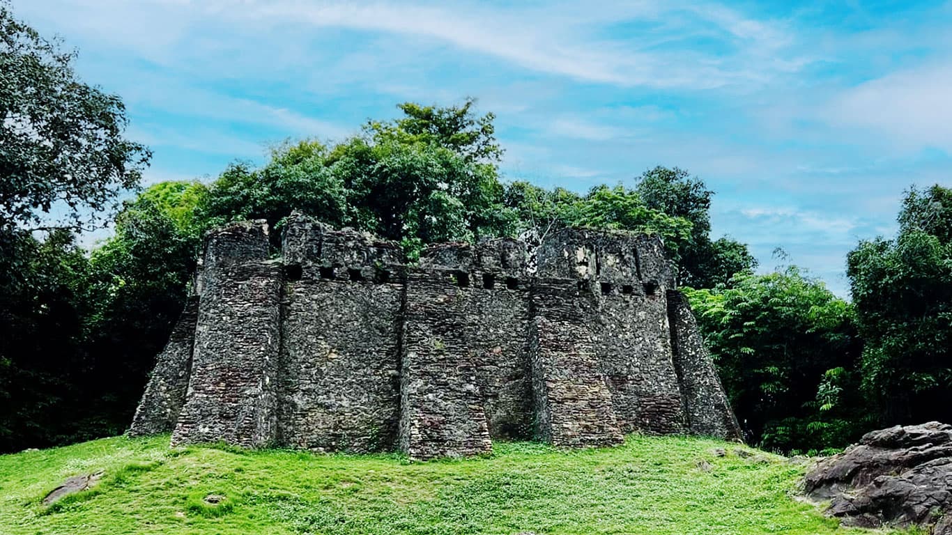
This polity was known as “Singora” (or variations of that name), and today, the remains of numerous forts and walls that were constructed by Dato Mogol’s son, Sultan Sulaiman Shah, still stand.
Songkhla, like Hà Tiên, is in a prime location for engaging in international trade, and yet, again like Hà Tiên, modern historians have not found much evidence of anything happening there before Dato Mogol arrived on the scene in the seventeenth century.
And again, like the case with Hà Tiên, that makes no sense.
How can it be the case that “not much” happened in these places until outsiders arrived on the scene? And why was it that the arrival of those outsiders occurred at roughly the same point in history?
In contrast, from my research, I have come to conclude that the area of (or near) what is now Songkhla was likely a major trading hub in the period from roughly 500-1,500 AD, and that further, it was somewhere in this area that the “royal district” of “Srivijaya/Srivishaya” that was destroyed by the Chola in the early eleventh century was located.

Today, there are some remains of the forts and walls that Sultan Sulaiman Shah ordered built in the seventeenth century. The above image (the highlighted part of which comes from the article mentioned below) shows the location of the forts. I have added some shots from Google Earth below as well.
Some Thai scholars have recently used a method called 2D Electrical Resistivity Tomography (ERT) and found strong evidence of both walls and moats buried underground between some of these forts (“Relevance of ERT to the Detection of Ancient City Basement Wall in Khao Daeng, the Old Town of Songkhla”).
The polity that Dato Mogol created was conquered by Ayutthaya in 1679, and a few years later the Siamese monarch tried to cede the territory to France. A French engineer, de la Mare, drew a map of Singora, with its forts and walls, and this recent study was an initial attempt to identify if the walls still existed, and it appears that some do.
That’s great! However, what I would also be interested in seeing is a study of the actual bricks. It looks like people have studied the bricks of later walls built in Songkhla during the nineteenth century, but I have not found any studies of the bricks in these seventeenth-century constructions.
It was often the case that new walls and forts were built from the remains of old walls and forts. My theory is that the area of Songkhla was a major trading center from long before the seventeenth century. It is possible that some of the materials in those seventeenth century walls could support that point.
Therefore, I hope some archaeologists will follow up on this ERT study by conducting some excavations and dating the bricks and other materials they find.
Because, again, like Hà Tiên, it can’t be the case that such a prime location for international trade was only “discovered” and developed in the seventeenth century.


Graham H. Dalrymple and Christopher M. Joll reckon Dato Mogol was sent in by the Ligor king, and most likely a Malay speaker.
We assume that there was already a settlement, a village or town established,worthwhile for such an appointment in the first instance, but we don’t know where this settlement was.
The singhanakhon area at the foot of khao daeng where those fortresses are, may have been an administrative and political centre, and there may have been another Singora, the business district.
The first mention of Singora on the western map was in the 1630s.
This Singora has always placed on the southern shore, the same side as the “old town “. Have not seen any map that depicts Singora on the Satingpra peninsula where the sultanate was based. What happened to the business district when the political capital was burned to the ground by the invading ayutthaya forces in 1680?
The business district (port) Singora at Bo Yang may have existed a lot earlier than what the official narrative suggests?
Thank you for these comments, they are really helpful.
And yes, I binge read two Dalrymple/Joll articles the other day (are there more?), and some of their individual writings, and they are all excellent!! If you are one of either of those authors then I congratulate and thank you for doing such great work. Those are works I will go back to again and again. They are really helpful!!!
You may or may not know what I have been writing about, but I have been looking at history from before the time that Dalrymple and Joll cover, and one theory I have is that “Shepo” in Chinese sources (which would have sounded something like “Java” a millennium ago), was the “Javaka” in some Siamese sources, was the Jaba in many Arabic sources, was where Songkhla is now, and was the Srivijaya/Srivishaya that the Chola reveled in completely destroying in the early eleventh century.
What got me convinced of that is a record which describes Shepo as a place from which the sea can be reached in the four directions (and different distances are given for each), and I can find no other place in Southeast Asia that fits that description other than this area around Songkhla with its access to trans-peninsular trading routes to Kedah (south) and Trang (west), as well as northern access to Nakhon Si Thammarat through the once extant passageway there, and of course directly to the sea to the east (and in following that hypothesis, I have found that mention of Shepo in other sources make sense).
Further, in Chinese sources, you can see Shepo go from being one of the premiere trading hubs in the region prior to the Chola attack, to being an isolated polity on the Malay Peninsula surrounded by vassals of Sanfoqi, which I argue is “Kambuja,” not “Palembang/Srivijaya.”
The Srivijaya/Srivishaya (the “royal district”) that the Chola destroyed was said to have multiple gates and was filled with riches. That area where a fort was (re-?)built in the 1600s covers an area where one could clearly imagine a place like that described in a Chola inscription.
In Chinese sources, the king of Shepo was said to climb up a mountain to look out at the sea. That fits perfectly with Khao Daeng. There was a canal made of gold – easily imaginable. There was also something unique about the geography, and that is mentioned in Chinese and Arabic sources, and I think they are referring to a narrow area where inland water met with the sea, and that fits this area as well.
It also makes perfect sense that you would have a “royal district” that was separate from the area where the trading was. What better location to protect all the riches a monarch got from trade than that area of Khao Daeng where you have a mountain protecting you on one side (the side where threats come from).
My point is that, besides the fact that the limited geographical information that we have for Shepo fits the Songkhla area perfectly, the location of Songkhla is just too good to have been “overlooked” until the seventeenth century. I think I have more than enough historical evidence to demonstrate that it was not overlooked, however, if some archaeologists could do some digging around Khao Daeng and maybe find an inscription stuck in a buried wall. . .
Yes, the works by Dalrymple/Joll are really inspiring and thorough, I find.
The authors, however, don’t attempt to connect the rise of the sultanate in the 17th century in Khao Daeng with the preceding settlements on the island (at that stage sathingpra was not completely joined up with the mainland). Nor they did the workings of the sultanate, where was the port and how it related to the canal system of the island, and its relationship with the fortified political centre at khao Daeng.
Wavell identified the settlements in Ranod area, wat pha kho complex (ban chumphon), a palace in catingpra area over the time. He also hinted the historical connection between Patalung and Satngpra (and Chaiya), but very vague.
Stargardt also indicates Ranod area (Kok Tong canal, utapao, wat sri yang and so on) may be the first irrigated area on the island. She excavated the moated palace in catingpra, along with the intricate irrigation and navigation canal networks. The hydro civilisation went into decline in the mid 14th century judging from the maintenance of the canal. That’s pretty much as we know about the tantalem island/satingpra.
So, yes, the time before the sultanate is extremely important yet hardly studied.
In the meantime, I think there may be a commercial district, the port area, which predates the sultanate and that’s where the Dutch and English east india companies had stores and offices. It may be at bo yang area where the 18th century old town sits today.
Or the port of Singora may have been in the different location, on the same southern shore. Near Bang Klam area,north of Hajai where all those canals to the south depart, for example?
Thanks for the comments!!
Just using logic, it doesn’t make sense to me that someone would create a canal across Sathing Phra if one could sail through natural openings to the sea at either end of that island. What I could imagine, however, is someone (like the ruler of Phatthalung) ordering a canal built there because his rivals controlled the natural access points at either end of Sathing Phra.
If, for instance, someone wanted to trade at Phatthalung, where a trans-peninsular route connected to Trang, as one left from there, one would either sail up or down the eastern coast of the Malay Peninsula. To do so, there were clear natural passageways at either end of Sathing Phra. There was no reason to go directly to the coast through a canal and then turn left or right, unless. . . those natural passageways were for some reason not passable, and the presence of rivals in those areas seems the most logical to me.
I would, therefore, assume that there were settlements at either end first, and that the canals crossing Sathing Phra came later.
As for Singora at Bang Klam, the information about Shepo indicates that the sea could be reached in the four cardinal directions. The distance to the east seems to have been the shortest (1 day, although another source has 1 month – I find that doubtful for various reasons). The idea that it was a little bit distant from the sea does make a place like Bang Klam a possibility. That’s were the end of the Kedah-Shepo route could have been (the southern sea access point).
Ultimately, I would imagine that there must have been multiple competing polities in this area. Places at the end of trans-peninsular routes may have been the most wealthy/powerful, but they probably had to bring under their authority other polities, such as ones located at the access points at each end of Sathing Phra and on the island itself, and inland polities along the trade routes.
I’m thinking the same, and ranod area may have been the one end of the emerging island at the time. The barrier island is believed to have grown from the southern end, khao daeng area. Makes sense the kok thong canal was one of the oldest, and the establishment of utapao settlement as the gateway. If I remember correctly, they built tanks there first, for irrigation, then extended an existing “river” for the east west canal to the sea. It could have been “developed” by the people from Patalung who had had seen the island emerge 20 kms off the coast and growing.
The southern passage, from Patalung, may not have been that simple. Mak and Nang Kham are pre-quaternary “islands”, like Khao Daeng, probably were fast silting up. In the meantime the narrow channel between Satingpra and Ko Mak was getting shallower. They seem desperately trying to keep the western passage open, around Pak Phayung. We can see Luang canal that’s the main one, and there are man made canals on these islands too, to handle the volume? I suspect Pak Ro canal that connects two lakes, was constructed precisely for this purpose.
So the passage from Patalung to the open sea, was getting challenged by the emerging island. This geomorphological change has brought about changes all around. To the north, next port is Ligor and was connected by a 20 km wide strait. It shrank rapidly and by the beginning of the 20th century, it was no longer. To the east, the emerging island. To the south, it was not the smooth sailing. That’s looking at it from Patalung.
Is this geological information that you mention documented somewhere? Or are these ideas that you have pieced together on your own that have not been published anywhere?
Based largely on two studies which I have mentioned in comments here before, and you said you had looked at them, one’s “ Coastal Evolution of Satingpra Peninsula, Songkhla Province:
Implications for Understanding Songkla Lagoon Formation” and the other “タイ南部ナコンシタマラート海岸平野における砂州の形成と発達
Geomorphic Development of the Nakhon Si Thammarat Coastal Plain, Southern Thailand.”
Oh, my bad!! Thank you though. I have these documented now.
And Tongsang, B. (2021). Evidence of Paleo Sea Level Change in Middle Holocene, Lower Part of Sating-Pra Peninsula Region, Southern Thailand. YRU Journal of Science and Technology, 6(2), 181–189.
As far as I can gather, assuming the translation is reliable, at least up till 2,350 years ago, the Satingpra was still under the sea, there was no lake. Well, it’s more accurate to say they were still developing, and indeed some parts had not emerged yet. I must say, the formation of a barrier island seems incredibly fast.
Prof Umitsu who did the study on the development of NST coastal plain, delivered a talk on the very subject, but I am unable to open the file.
https://www.jstage.jst.go.jp/article/ajg/2005s/0/2005s_0_77/_article
Hi, do you think which ethno-linguistic groups were the dominant inhabitants of Mekong delta during the Funan period, Austroasiatic or Austronesian, prof. Kelley?
As far as I know, the dominant group should be Austroasiatic. It’s possible that Austronesian speakers were in the ports/rivers, but I haven’t seen any evidence that would suggest that the dominant population was Austronesian speaking.