

There is a place mentioned in the New History of the Tang called “Wendan” 文單. It appears in an itinerary that was recorded by Tang dynasty scholar-official Jia Dan in the eighth century.
For over a century, scholars have been trying to figure out where it was. I think I have evidence here to help resolve this issue.
Everyone that I am aware of, has seen Jia Dan’s itinerary as extending from a place in what is now Vietnam called Huanzhou 驩州, meaning “Huan Prefecture,” to a walled city called Wendan 文單, and then after that, to the sea. I don’t think that is correct, but let me explain what others have said first.
Huanzhou is a relatively stable place name. Scholars think that it was centered in the area of what is now Vinh in Nghe An Province, that is, in north-central Vietnam. And indeed, there is a pass in the Annamite Cordillera to the west of Vinh which one could travel through and eventually reach places in what is today Laos and Cambodia.
However, the place names and information about distances in Jia Dan’s itinerary make it difficult to clearly document the route. As a result, people have come up with various different ideas about where Wendan was.
In the early twentieth century, Sinologist Paul Pelliot wrote about Jia Dan’s itinerary and could not come to a clear conclusion of where Wendan was located. He noted that his colleague, archaeologist Louis Finot, shared with him information about an inscription from a place called Sambor, in Cambodia, which indicated that this was an important political center at the time. While it seemed reasonable to Pelliot that Wendan would indicate such a place as Sambor, he acknowledged that the distances in Jia Dan’s itinerary were too short to mark a route from Nghe An to Sambor.
Before we go further, let us look at the passage that scholars, starting with Pelliot, have tried to understand.
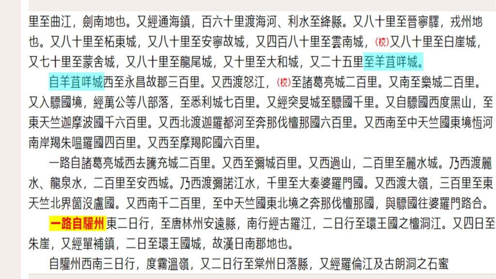
自驩州西南三日行,度霧溫嶺,又二日行至棠州日落縣,又經羅倫江及古朗洞之石蜜山,三日行至棠州文陽縣。又經漦漦澗,四日行至文單國之算臺縣,又三日行至文單外城,又一日行至內城,一曰陸真臘,其南水真臘。又南至小海,其南羅越國,又南至大海。
From Huan Prefecture [Huanzhou], travel southwest for three days, cross Wuwen Ridge, then another two days to reach Riluo District in Tang Prefecture [Tangzhou]. Pass through the Luolun River and Stone Honey Mountain in Gulang Grotto, then three days to Wenyang District in Tang Prefecture. Pass through Lili Ravine, then four days to Suantai District in the Kingdom of Wendan, another three days to the outer city of Wendan, and one more day to the inner city, also known as Land Zhenla, with Water Zhenla to its south. Continue south to a small sea, south of which is the Kingdom of Luoyue, and further south to a great sea.
In the Tang dynasty period, “Huanzhou” meant “Huan Prefecture,” and a prefecture (zhou 州) oversaw various “districts” (xian 縣). Huan Prefecture was established in 598 by the preceding dynasty, the Sui dynasty.
This itinerary heads southwest from Huan Prefecture through a place called Wuwen Ridge (which we will talk more about below) to a place called Tang Prefecture. Although this is a Chinese administrative term, this “Tang Prefecture” was not part of the Tang dynasty empire, and therefore, the Chinese administrative terms that are used in the passage from this point onward must be seen as an effort to describe a non-Chinese political reality in Chinese administrative terms.
The route passes through two “districts” in Tang Prefecture, as well as a “grotto” (dong 洞), a term which, in Chinese usage, can refer to something like an autonomous aboriginal settlement.
After passing through various administrative units in Tang Prefecture, the route then arrives at territory under the authority of Wendan, first a district (Suantai), and then the outer wall of Wendan, and finally its main city.
Note that although certain distances are recorded in terms of the number of days to travel, the statement, “pass through the Luolun River and Stone Honey Mountain in Gulang Grotto,” doesn’t indicate how long that took.
There is also no indication of distances in the part of the itinerary that records the journey from Wendan to the sea. Nonetheless, that is the one part that I would argue is the clearest to understand.
We have “a small sea, south of which is the Kingdom of Luoyue, and further south to a great sea.” I would argue that the small sea indicated the Tonle Sap, and the great sea, the Gulf of Thailand, where, as I have argued ad nauseum by this point, the main maritime access point to “Cambodia” was located at what is now Ha Tien.
In between was “Luoyue” 羅越, which looks to me like a strong candidate for “Longvek,” an important settlement between the Tonle Sap and the Gulf of Thailand. However, I don’t know if we have evidence for that name this early.
In any case, while the information here is somewhat vague, it is nonetheless difficult to see it describing a journey from Nghe An Province to a place with an outer wall that is a day’s journey from its inner city.
If this was a reference to Vat Phou in southern Laos or some early site in the Angor region, then one would think that some reference to a big river (the Mekong) would be included. However, the text doesn’t have any such information.
The place that Finot referred to as Sambor is now known as Sambor Prei Kuk. It is a famous archaeological site, and was a major pre-Angkorian political center. That site does potentially fit the description of a polity that had an inner city and an outer wall, however, again, it’s difficult to see the above itinerary as describing a journey from Nghe An all the way to Sambor Prei Kuk.
In fact, however, I think it does, and we can see this if we take a step back and look at the text again, as well as some related information.

This passage about the journey to the sea is placed in between two itineraries that trace routes to India, one overland from the Red River Delta to Yunnan and onward, and the other by sea from Guangdong.
Meanwhile, the passage which many scholars have examined, is actually preceded by another passage, which I have not seen anyone mention, and which is as follows:
一路自驩州東二日行,至唐林州安遠縣,南行經古羅江,二日行至環王國之檀洞江。又四日至朱崖,又經單補鎮,二日至環王國城,故漢日南郡地也。
One route: From Huan Prefecture, travel east for two days to Anyuan District in Tanglin Prefecture. Travel south, passing through the Guluo River, two days to Tandong River in the Kingdom of Huanwang. Another four days to Zhuya, then pass through Danbu Defense Command, two days to the city of the Kingdom of Huanwang, which was the territory of the ancient Han dynasty’s Rinan Commandery.
This passage describes the route from Huan Prefecture to the south to “the Kingdom of Huanwang” 環王國, which was how the Cham world was referred to by Chinese at that time (or the most powerful kingdom in that world).
Immediately following this passage, we get the passage which scholars have examined, and which begins with “From Huan Prefecture. . .”
Let’s look at the two passages together, as we find them in the New History of the Tang.
一路自驩州東二日行,至唐林州安遠縣,南行經古羅江,二日行至環王國之檀洞江。又四日至朱崖,又經單補鎮,二日至環王國城,故漢日南郡地也。
自驩州西南三日行,度霧溫嶺,又二日行至棠州日落縣,又經羅倫江及古朗洞之石蜜山,三日行至棠州文陽縣。又經漦漦澗,四日行至文單國之算臺縣,又三日行至文單外城,又一日行至內城,一曰陸真臘,其南水真臘。又南至小海,其南羅越國,又南至大海。
One route: From Huan Prefecture, travel east for two days to Anyuan District in Tanglin Prefecture. Travel south, passing through the Guluo River, two days to Tandong River in the Kingdom of Huanwang. Another four days to Zhuya, then pass through Danbu Defense Command, two days to the city of the Kingdom of Huanwang, which was the territory of the ancient Han dynasty’s Rinan Commandery.
From Huan Prefecture, travel southwest for three days, cross Wuwen Ridge, then another two days to reach Riluo District in Tang Prefecture. Pass through the Luolun River and Stone Honey Mountain in Gulang Grotto, then three days to Wenyang District in Tang Prefecture. Pass through Lili Ravine, then four days to Suantai District in the Kingdom of Wendan, another three days to the outer city of Wendan, and one more day to the inner city, also known as Land Zhenla, with Water Zhenla to its south. Continue south to a small sea, south of which is the Kingdom of Luoyue, and further south to a great sea.
Look at the two paragraphs above. What is their relationship? The first one describes a route. Then what is the second paragraph doing? Describing another route? If so, we would expect that paragraph to begin with a character like “also” 又, meaning, “Also, you can go from Huan Prefecture to. . .” to indicate that it was talking about another route. However, it doesn’t do that.
If we then look at the passage before this one (the one about the overland route from the Red River Delta), we see a similar structure of information, but one which makes more sense.
In particular, we see an example where the text mentions reaching a place called “Yangjumie Citadel” (至羊苴咩城). and then it says, “From Yangjumie Citadel. . .” (自羊苴咩城) and continues the itinerary.
I would argue that the two paragraphs above should connect in the same way. The first paragraph ends with reaching Huanwang. The second paragraph should then continue from there by saying “From Huanwang, travel southwest. . .” rather than what it actually does, which is to jump back to Huan Prefecture and start another route, “From Huanzhou [Huan Prefecture], travel southwest. . .”
In terms of the overall logic of the text, this would make more sense. However, there is other information which supports this understanding.
First, there is a section on the Huanwang Kingdom in this same text, where its location is identified. This is what it says:
環王,本林邑也,一曰占不勞,亦曰占婆。直交州南,海行三千里。地東西三百里而贏,南北千里。西距真臘霧溫山,南抵奔浪陀州。
Huanwang was originally Linyi, also called Zhanbulao, or Zhanpo. It lies directly south of Jiaozhou, three thousand leagues by sea route. The territory extends over three hundred leagues from east to west, and one thousand leagues from north to south. To the west, it borders Zhenla’s Wuwen Mountain; to the south, it reaches Benlangtuo Prefecture.
This “Wuwen” 霧溫 in “Wuwen Mountain” here, which is described as belonging to Zhenla (“Cambodia”), is the same as the Wuwen in the Wuwen Pass which the itinerary says (right at the place where I argue the Huanzhou is a mistake for Huanwang) one crossed in journeying southwest from “Huan Prefecture.”
Does the use of “mountain” in one passage and “pass” in another mean that we are looking at two separate places with the same name? No. “Mountain” and “pass” are easily interchangeable in these contexts.
In other words, this place name, Wuwen, was a significant marker of the border between Huanwang (“Champa”) and Zhenla (“Cambodia”). This strengthens my argument that the “Huanzhou” at the start of the second paragraph in the itinerary should be “Huanwang,” and that therefore, the itinerary from Huan Prefecture to Wendan first went south to Huanwang, and then turned southwestward, heading past Wuwen mountain/pass.
Finally, there is another document which supports this understanding, and it is an inscription from 1159 entitled “Preface to the Inscription on the Stone Stele of Duke Li, Defender-in-Chief of the Great Yue Kingdom (鉅越國太尉李公石碑銘序).
This is an inscription that was made in honor of a Lý dynasty official by the name of Đỗ Anh Vũ, and it contains a passage about a conflict with Wendan. Here is the passage:
天章【漳】寶嗣三年太簇之月,升平日久,四海無虞。文單犯其南鄙。帝遣公与太傅李公平統三十萬兵,循海至日南音野。公望見賊營而謂曰:《天子之兵,征而無戰,裸身質俗,天其必誅》。于是風掁山搗,賊乃怖懼,遂潰而歸。公兵追奔逐北,斬將擒俘,至霧溫而還。
In the third year of the Thiên Chương Bảo Tự era [1135], in the month of Thái Tốc, peace had endured for a long time, and the four seas were without peril. Wendan invaded the southern frontier. The emperor dispatched the Duke, along with Grand Mentor Lý Công Bình, to command 300,000 troops, following the coast to Âm Dã/Yinye in Nhật Nam/Rinan. The Duke gazed upon the enemy camp and declared: “The Son of Heaven’s troops campaign without battle; with their naked bodies and vulgar customs, Heaven will surely punish them.” Thereupon, winds stirred and mountains shook; the bandits were terrified, thus they dispersed and returned home. The Duke’s troops pursued the fleeing foes, beheading generals and capturing prisoners, reaching Vụ Ôn/Wuwen before turning back.
Here again we have mention of “Wuwen.” And here again, I think placing it in the area of Nghe An would be too far north.
Đỗ Anh Vũ led a fleet down to Nhật Nam/Rinan, and then chased the Wendan troops, driving them to Vụ Ôn/Wuwen.
As we saw in the passage above about the location of Huanwang, it was said to be in the “the territory of the ancient Han dynasty’s Rinan Commandery.”
In 1135, Rinan Commandery no longer existed, however, I would argue that this term was used in this inscription as a general reference to the region to the south of the Lý dynasty empire, where Huanwang had earlier been located, and from where the Wendan attack initiated.
Taken together, what I think all of the above information demonstrate is that there was a route between the Cham world and Zhenla, and the itinerary that Jia Dan documented passed over that route. Jia Dan’s itinerary did not go from Huan Prefecture directly southwestward into what is now Laos. Instead, it first went south to the Cham area, and then headed southwestward through the mountains.
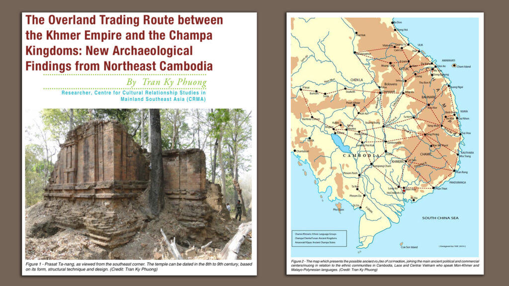
In an essay that he published a few years ago on “The Overland Trading Route between the Khmer Empire and the Champa Kingdoms: New Archaeological Findings from Northeast Cambodia,” archaeologist Tran Ky Phuong pointed out that there is evidence for such a route, including a recently discovered “brick temple Prasat Ta-nang (Yeak Naang), situated in a Jarai ethnic village called Dor Touch/ Dor Pir Village, Northeast Cambodia. Located near a small river named O Tang, about 10km from the Cambodia-Vietnam border” in Ratanakiri Province.
Tran Ky Phuong notes further that architecturally, the temple possesses Pre-Angkorean and Cham architectural elements. Further, that it is in a Jarai area is a reminder that this region is multi-ethnic, and that could explain why a “grotto” was mentioned in the itinerary, with that term possibly indicating an area inhabited by a distinct ethnic group.
Following such a route makes it much easier to see Wendan as indicating Sambor Prei Kuk.
Everything points in that direction except for one word—the word, “Huanzhou,” at the beginning of the second paragraph in the itinerary.
In terms of textual logic, that term’s placement there looks like a mistake. In terms of its relationship to the key geographical location of Wuwen, it also doesn’t make sense.
What I am still not certain about is where exactly the route went, but it makes much more sense to me to look for a route that first went south from Nghe An to a Cham area and then headed across the mountains, reaching Sambor Prei Kuk, a major political center in that area, and then heading southward to the sea at Ha Tien, where one could connect to maritime trade routes.
Finally, I’d like to thank FB friend Nhat Anh Tran for pointing this issue out to me and getting my interest piqued.
It’s so nice to come back from the holidays with an intriguing article, Prof.! Still, I have a minor wonder: where the Wuwen pass is located in your guess.
Thank you for the kind words. I have no idea where that mountain was. I’m just starting to look into this topic, so perhaps I’ll have an answer later. If I do, I’ll let you know.