In the previous post, I mentioned that there was a tribute mission from the Chola Kingdom in 1015 that was led by a certain Suolisanwen (娑里三文) with a deputy envoy Pu Shu 蒲恕 (or Pu Jiaxin 蒲加心), and I argued that the “Pu” here is the Cham honorific, pu/po.
This was the first tribute mission to China from the Chola kingdom, and the tribute was sent after a Chinese merchant had visited that country and encouraged the king to send a tribute mission.
The History of the Song contains information about the itinerary. This is what it records:
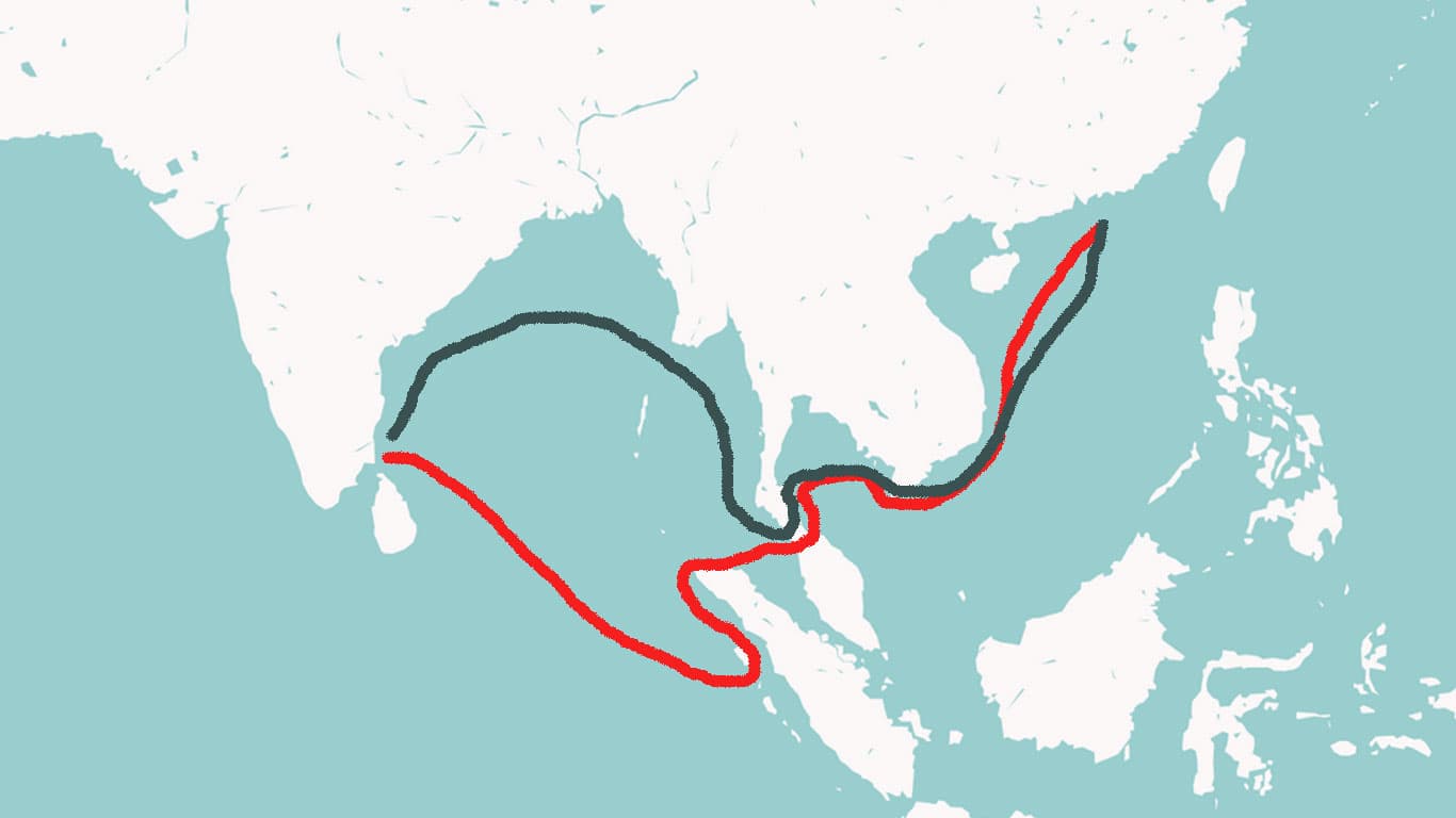
三文離本國,舟行七十七晝夜,歷郍勿丹山、娑里西蘭山至占賓國。又行六十一晝夜,歷伊麻羅里山至古羅國。國有古羅山,因名焉。又行七十一晝夜,歷加八山、占不牢山、舟寶龍山至三佛齊國。又行十八晝夜,度蠻山水口,歷天竺山,至賓頭狼山,望東西王母塚,距舟所將百里。又行二十晝夜,度羊山、九星山至廣州之琵琶洲。離本國凡千一百五十日至廣州焉。
[Suoli] Sanwen departed from his kingdom, and traveling by boat for 77 days and nights, passing by Mount Nawudan 郍勿丹山, Mount Suolixilan 娑里西蘭山, reached the kingdom of Zhanbin 占賓國. Journeying onward for 61 days and nights, and passing by Mount Yimaluoli 伊麻羅里, he reached the kingdom of Guluo 古羅國. The kingdom has a Mount Guluo 古羅山, hence its name. Traveling again for 71 days and nights, and passing Mount Jiaba 加八山, Mount Zhanbulao 占不牢山, and Mount Zhoubaolong 舟寶龍山, he reached the kingdom of Sanfoqi 三佛齊國. Journeying on for 18 days and nights, he crossed the Mount Man estuary 蠻山水口, and passed Mount Tianzhu 天竺山, reaching Mount Bintuolang 賓頭狼山. Looking to the east, the Tomb of the Queen Mother of the West [was visible], about a hundred leagues from the ship’s position. Journeying for another 20 days and nights, crossing Mount Yang 羊山, Mount Jiuxing 九星山, he reached Pipa Islet in Guangzhou. Departing from his kingdom, it took a total of 1,150 days to reach Guangzhou.
Ok, one obvious issue here concerns the numbers. This passage mentions 247 days of travel, and yet the journey reportedly took 1,150 days.
How do we explain this?
While it is possible that some numbers here might be wrong, what I think it points to is a fact that is rarely recognized, which is that sea travel in this period was primarily “local.” One did not sail in a single ship that went a constant speed all of the way from South Asia to China.
Yes, there is evidence of some ships making such a journey. However, I think such ships were the exception rather than the rule. Instead, one traveled each leg of the journey on a different ship, each of which went at a different sped, and one often had to wait for months in between each leg of the journey either for the consigned ship to arrive or to arrange for passage to the next destination.
There are places in this passage that are called “mount” and places that are called “kingdom.” It could me that the “mounts” referred to the places where these envoys passed by, whereas the “kingdoms” were places where they stopped and spent time waiting to embark on the next stage of their trip.
This passage has been studied before, and a translation of this passage by Japanese historian Noboru Karashima was published in the 2009 book Nagapattinam to Suvarnadwipa: Reflections on the Choa Naval Expeditions to Southeast Asia (Singapore: ISEAS).
Professor Karashima provided some explanations for the information in this passage in footnotes, as follows:
“It is very difficult to identify many of the place names on the route mentioned here. If the embassy traveled straight across the Bengal Bay, Na-wu-dan shan (郍勿丹山), Suo-li-xi-lan-shan (娑里西蘭山) and Zhan-bin guo (占賓國) may be identified with places in the Andaman and Nicobar Islands, and Yi ma-luo-li shan (伊麻羅里山) with a site at the northern tip of Sumatra. However, if the embassy took the northern course, these places must be identified with those on the Bengal Bay coast, including Myanmar. The identification of some places have been suggested in the past studies by Pelliot, Hirth, Rockhill, et al. but the most detailed discussion on it is found in O.W. Wolters, ‘Landfall on the Palembang Coast in Medieval Times,’ Indonesia 20 (1975), 1–57.”
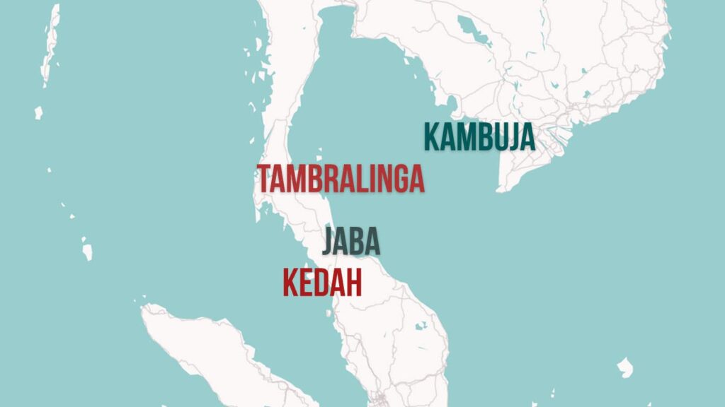
“Gu-luo (古羅) can be identified with the present-day Kedah, known as Kalah by Arab traders in the medieval period. The mountain of the place seen from the offing must have been a landfall for navigators.”
Wolters suggests Cham Pulau, a small island off the west coast of Lingga Island. WXTK gives gu (古) for zhan (占).
“The name San-fo-qi (三佛齊), which appears in Chinese records from the 10th century, is applicable to at least three kingdoms which ruled in the Malacca Strait region, namely, the kingdom whose headquarters was in Palembang in Sumatra, the kingdom which established its power in Jambi, a little north of Palembang, after the middle of the 11th century, and the kingdom in Kadaram (the Kedah area) in the Malay Peninsula. San-fo-qi in the text seems to refer to Palembang. In the early Chinese sources the kingdom in Palembang appears as Shi-li-fo-shi (室利佛逝), which was identified with Srivijaya by G. Cœdès. There are many problems concerning Srivijaya and San-fo-qi including their relations and state structure. Those problems have been discussed by various scholars in the past including O.W. Wolters (“Studying Srivijaya”, Journal of the Malaysian Branch of the Royal Academic Society, LII-2, 1979) and Pierre-Yves Manguin (“Palembang and Srivijaya: An Early Malay Harbour-City Rediscovered”, Journal of the Malaysian Branch of the Royal Academic Society, LXVI-1, 1993).” (311)
What do we see here? The same cast of characters: Pelliot, Cœdès, Wolters, etc.
In other words, Professor Karashima followed the “orthodox” view that Sanfoqi was “Srivijaya,” however, because that view is not true, scholars have had great difficulty getting the sources to support it. That is why Professor Karashima could not even indicate where it was located: maybe it was at Palembang, maybe Jambi, maybe Kadaram. . .
Further, what do we see if we dig a bit deeper? The same problems.
For instance, O. W. Wolters wrote about this passage and transcribed the place, Jiaba 加八, as “Ka-pa” and said that this was “a name that defies exact identification.” He then wrote in a footnote: “Perhaps the word is an abbreviation of the Malay kepala (‘head’), in the sense of being a headland.” (50)
The main system for transcribing Chinese in Roman letters in 1975, when Wolters wrote this, was the Wade-Giles system. In Wade-Giles, 加八 is rendered chia-ba. There is no “ka”sound in Wade-Giles. This is something Wolters invented, and that invention led him to imagine a connection between “ka-ba” and “kelapa.” However, the term to compare is chia-ba/jiaba and it clearly has nothing to do with kelapa.
This is very symbolic of the entire body of scholarship on “Srivijaya.” Imagine that Sanfoqi is Srivijaya and then distort the historical sources to try to get them to support that idea.
Professor Karashima was also unable to identify Jiaba. However, it is very easy to do so. Let’s examine this issue.
I agree with Professor Karashima that it is difficult to identify the place names before Guluo 古羅 which he argued was Kedah. Those are all terms that only appear in reference to this itinerary.
As for Guluo, I have previously made the case for seeing this “gu” in this name as coming from the Mon-Khmer term for an island “koh,” which we find many of in the area to the north of Kedah. Further, that region contains archaeological remains and was clearly a place that was connected to trans-peninsular routes that crossed to what is now Nakhon Si Thammarat and Surat Thani.
However, I’m ok with seeing this as possibly indicating Kedah. Either way, we both see this place as indicating a location on the western side of the Malay Peninsula, across from the area where I argue there was a major trans-peninsular trading route that went from what is now Trang to Phatthalung and Kedah to Songkhla, an area that I argue was referred to by foreigners as “Java/Jaba” (as we see in Arabic and Chinese sources).
Ok, so what is the next place on this itinerary mentioned after Guluo/Kedah?
It is Jiaba. No, Dr. Wolters, not “Ka-pa,” Jiaba.
Kinda sounds like “Java/Jaba” doesn’t it?
What comes next?
Zhanbulao, Zhoubaolong, and Sanfoqi (占不牢、舟寶龍、三佛齊).
Zhanbulao doesn’t make sense. The same sounding characters were used to refer to Pulau Cham near Champa. Zhoubaolong also doesn’t make sense, unless we change the first character 舟 to a very similar alternative 丹 and then you get “Danbaolong” 丹寶龍, which could possibly refer to Tambralinga, a kingdom that was located somewhere on the eastern side of the Malay Peninsula, possibly at what is now Nakhon Si Thammarat.
Finally, as I’ve demonstrated thoroughly by now, Sanfoqi was Kambuja. And I won’t go into detail about the places mentioned after that, but I can easily demonstrate that they are clearly referring to the route around the southeastern tip of the Indochinese Peninsula, then up past Champa to China.
So, from Kedah, through Jaba, possibly past Tamralinga to Kambuja. . . we see here very clear evidence of the trans-peninsular route that crossed in the area from Kedah to Lake Songkhla.