

In the third century, there were a couple of envoys who traveled to Funan and wrote accounts of the area. Namely, the following:
Kang Tai 康泰, Account of Foreign Kingdoms in the Wu Period (Wushi waiguo zhuan 吳時外國傳). This work was also known as the Account of Funan (Funan zhuan 扶南傳) and the Account of the Land and Customs of Funan (Funan tusu zhuan 扶南土俗傳).
Zhu Ying 朱應, Record of Unusual Things from Funan (Funan yiwu zhi 扶南異物志) and Record of Funan and Further South (Funan yinan ji 扶南以南記).
Then there was also an official stationed on the island of Hainan who wrote an account of southern lands: Wan Zhen 萬震, Record of Unusual Things from Southern Lands (Nanzhou yiwu zhi 南州異物志).
These works are all lost, however individual sentences and short passages from these works can be found in later texts, particularly Tang and Song dynasty period encyclopedias.
Scholars have long relied on that fragmented information in encyclopedias to try to figure out what Chinese recorded about early Southeast Asia, but doing so is VERY DIFFICULT and FRUSTRATING AS HELL!!!
Why? Because the information is all fragmented into little pieces and it is extremely difficult to see how it might relate to each other. Historian Andrew Chittick has recently attempted to do this, and I have total respect for that effort, and I also thought that his effort to make sense of the fragmented sources was as good as could reasonably be expected, until. . . I came to realize that there is a text from the early fourth century that still has a lot of this information “intact.”
That text is the Grand Clarity Scripture of Divine Elixir Made from Liquid Gold (Taiqing jinye shendan jing 太清金液神丹經) attributed to Ge Hong 葛洪 (283–343 CE), and I have translated the relevant part on the geography of parts of maritime Southeast Asia here.
While Ge Hong does appear to have traveled to Funan, and while he does have some information about Funan that appears to be novel, I can see that a lot of the information that he provides about other places in Southeast Asia clearly comes from Wan Zhen’s Record of Unusual Things from Southern Lands.
Again, however, what is so fantastic about Ge Hong’s text is that this information is not fragmented, as it is in later encyclopedias, and because of that, we can identify the location of places that he mentioned with much more accuracy.
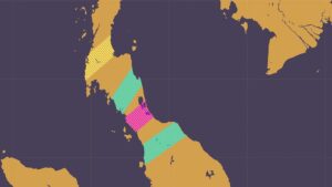
Ge Hong mentions a place that he called Dianxun 頓遜, which in later texts is referred to as Dunxun 典遜. I think all scholars agree that this was somewhere on the western side of the Gulf of Thailand. If I were to guess, I would say (based on information that I’ve seen in multiple texts) that it was probably somewhere around where Chumpon is today.
Ge Hong then mentions a place called “Juzhi” 句稚. This could also be pronounced “Gouzhi.” Here is what he said.
句稚國,去典遜八百里,有江口,西南向,東北入,正東北行,大崎頭出漲海中,水淺而多慈 [8a] 石,外徼人乘舶船皆鐵葉,至此崎頭,閡慈石不得過,皆止句稚,貨易而還也。
The kingdom of Juzhi 句稚 lies 800 leagues from Diasun 典遜. There is a river estuary that faces to the southwest and which you enter from the northeast. Proceeding directly northeast, one reaches a large cape that juts into the Swelling Sea [Zhanghai 漲海]. The water here is shallow and filled with lodestones [ci shi 慈石]. Foreign merchants who travel in ships sheathed in iron reach this cape, but because of the lodestones, their ships are blocked and cannot pass. Therefore, they all stop at Juzhi, where they conduct trade and then return.
This is a perfect description of the area around what is now Surat Thani and Koh Samui. On the northeast side of the bay where Surat Thani is now located, the Ta Pi river flows to the southwest. Heading to the northeast, there is a cape, now known as Laem Thuat, and various islands relatively near to each other. This could be the area that was “filled with lodestones.”
There is a famous itinerary in the New History of the Tang that I think pretty much everyone, from Paul Pelliot onward, has tried to argue went through the Straits of Melaka, but I have argued that it circled the Gulf of Thailand and crossed over the Malay Peninsula in the Songkhla – Kedah area.
In that itinerary, right at the place where I argue it passes the islands of Ka Pha Ngan and Koh Samui, it is recorded that “foreigners call it ‘zhi’” (蕃人謂之「質」). In terms of pronunciation, in the past, this “zhi” and the one in Juzhi (稚) would have sounded very similar.

Further, the “ju/gou” in Juzhi or Gouzhi, I would argue, is undoubtedly the Mon-Khmer term for an island, “ko.” This was thus Zhi Island.
As such, while there was perhaps one island there that was known by this name, probably Koh Samui given its size, the term was used here to indicate the larger area, including not only the cape that sticks out into the Gulf of Thailand, but also the bay where the Ta Pi river flows to the southwest.

Further, it’s interesting that this is recorded as a place where trade took place. In the later itinerary from the Tang period, I argue that it shows that ships followed the coast, but that at some point, veered across the Gulf of Thailand to the area of Ko Pha Ngan and Koh Samui.
We just saw in the previous post that ships did not sail directly across the Gulf of Thailand, or what was known to Chinese mariners in the early centuries AD as the Swelling Sea. However, Ge Hong states regarding the route to Dupo/Shepo, a term that I argue referred to the Lake Songkhla – Kedah/Trang area, “From Funan, one can sail directly across the sea” (從扶南船行直截海度).
I suspect that at some point in the coastal journey, mariners “sail[ed] directly across the sea.” Given how prominent Ko Pha Ngan and Koh Samui are (there are no other large islands in that part of the Gulf of Thailand), it would make sense that they would serve as landmarks for that crossing. So, to shorten the journey, and perhaps more importantly to avoid the lodestones, perhaps ships cut across the sea from say Chumpon or some other area in the western part of the gulf to those islands and then continued further.
Let us now look at the next place that Ge Hong mentioned, Geying 歌營.
歌營國,在句稚南,可一月行乃到其國。又灣中有大山林迄海邊,名日蒲羅。中有殊民,尾長六寸,而好啖人。論體處類人獸之問,言純為人則有尾且啖人,言純為獸則載頭而倚行,尾同於獸而行同於人。由形言之,則在人獸之間,末黑如漆,齒正白銀,眼正赤,男女裸形無衣服,父子兄弟姊妹露身對面伺臥,此是歌營國夷人耳,別自有佳人也。
The kingdom of Geing 歌營 lies to the south of Juzhi. It takes about one month of travel to reach this land. In a bay within its territory is a large forested mountain that stretches to the seacoast, called Puluo 蒲羅.
Within it live a peculiar people whose tails are six inches long and who are said to be fond of eating humans. In bodily form they lie somewhere between human and beast: if one says they are fully human, then they nonetheless have tails and eat people; if one says they are fully beasts, then they carry their heads upright and walk erect. Their tails are like those of beasts, but they walk as humans do.
In appearance, they fall between man and animal. Their skin is jet black like lacquer, their teeth pure white like silver, and their eyes bright red. Men and women go naked, without clothing. Fathers, sons, brothers, and sisters all lie together exposed, face to face.
These are the barbarians [yiren 夷人] of the kingdom of Geying, but among them, there are also good people.
Note that nothing is mentioned about traveling by boat from Juzhi to Geying. This, I would argue, is because the month journey is a reference to an overland passage. Going overland to the south from Surat Thani would take one to what is now Phang Nga Bay.
The “large forested mountain that stretches to the seacoast” called Puluo 蒲羅 could be a reference to what is now Phuket or the eastern coast of the bay, depending on which direction one went. Alternately, it could be a reference to the large island in the middle of the Phang Nga Bay, Ko Yao Yai.

On that note, whenever I come across the term “puluo,” I always see that as potentially indicating “pulau/pulo,” an Austronesian term for “island.” However, the main term for islands in this region is the Mon-Khmer “ko,” like the “Ko” in “Ko Yao Yai,” and the “ge” in “Geying” is again likely that term.
However, as we just saw in the case with Juzhi, there were traders arriving there from different directions, and as you headed south from what is now Surat Thani, you entered the world of Austronesian language speaking peoples. Such was the case on the western side of the Malay Peninsula as well. As such, perhaps the name “Puluo” was somehow picked up from mariners who spoke an Austronesian language.
Given that the people there were reportedly cannibals, it doesn’t sound like the kind of place that a mariner would want to visit to ask, “Hi guys! Um, so, everyone says this place is called ‘pulau,’ but that’s an Austronesian term and we’re still in Mon-Khmer territory, so I wonder if you guys might be willing to maybe clarify this for us. Yea? Sound good?”
Munch, munch, munch. . .
Finally, I should also note that the references to naked people and dark skin all fits with later accounts of places in the Andaman and Nicobar islands, so this passage could be mixing different pieces of received information.
On that note, there is a passage that appears to come from Kang Tai’s Land and Customs of Funan that states:
又有加營國北、諸薄國西山周三百里,從四月火生,正月火滅。火燃則草木葉落,如中國寒時。人以三月至此山,取木皮績為火浣布。
Also, there is a mountain north of the kingdom of Geying and west of the kingdom of Zhubo [same as Dubo/Shepo], with a circumference of 300 leagues. From the fourth lunar month, fire arises; by the first month, the fire is extinguished. When the fire burns, the leaves of the grass and trees fall, as during cold times in China. In the third lunar month, people go to this mountain to gather bark from the trees, which they spin into fire-washed cloth [i.e., asbestos cloth].
Assuming that this “fire-washed cloth” is asbestos cloth, this is a mythologized explanation of how it is produced. But putting that aside, the geographic information here fits perfectly with what we have been describing.
The place that is described here is likely Barren Island, where there is an active volcano. These islands in the Andaman sea were passed by mariners who took the northern route to India, and this was often referred as a place inhabited by “naked people.”

Finally, in a mid-sixth-century work by Yang Xuanzhi 楊衒之 called Record of the Monasteries of Luoyang (Luoyang qielan ji 洛陽伽藍記), there is a passage that records information about the journey from Geying to Juzhi. In particular, it talks about the journey of an Indian Buddhist monk, Bodhibhadra (Putibatuo 菩提拔陁), presumably a reference to Buddhabhadra (Fotuobatuoluo 佛陀跋陀羅), to the “Xiaoyan” 蕭衍 kingdom, a reference to the Liang dynasty empire under the rule of Emperor Wu of the Liang (r. 502-549).
To quote:
南中有歌營國,去京師甚遠,風土隔絕,世不與中國交通,雖二漢及魏,亦未曾至也。今始有沙門菩提拔陁至焉。自云:「北行一月,至句稚國,北行十一日,至典孫國,從典孫國北行三十日,至扶南國。方五千里,南夷之國,最為強大。民戶殷多,出明珠金玉及水精珍異,饒檳榔。從扶南國北行一月,至林邑國。出林邑,入蕭衍國。」
In the southern regions there is the kingdom of Geying, which lies very far from the capital. Its customs and environment are isolated and cut off, and throughout the generations it has not had contact with the Middle Kingdom. Even during the Han and Wei dynasties, no one ever reached it. Now, for the first time, a śramaṇa [Buddhist monk] named Bodhibhadra has visited there.
He said: “Traveling north for one month, one reaches the kingdom of Juzhi. Traveling north another eleven days brings one to the kindgom of Diansun. From Diansun, traveling north for thirty days leads to Funan, a land stretching 5,000 li. Among the southern barbarian states, it is the most powerful and dominant. Its population is large and prosperous. It produces pearls, gold, jade, rock crystal, and other rare and wondrous goods. It is rich in betel palms. From Funan, traveling north for one month brings one to the country of Linyi. Exiting Linyi, one enters the kingdom of Xiaoyan.
Taking all of the above together, there is absolutely no doubt in my mind but that we have perfectly clear evidence here of the trans-peninsular crossing between Surat Thani and Phang Nga Bay.
The project that I mentioned above by Andrew Chittick is still super important. There is a ton of great information on his website. However, that effort to make sense of the “fractured” information that we find in Tang-Song encyclopedias needs to now be examined in tandem with the “intact” information from Ge Hong’s text.
That is what I have attempted to do here in the case of Juzhi and Geying.


Between Kedah and Patani also got Old trading routes mentioned in Kitab Tarikh Patani during Langkasuka Period
Thank you for this information.
I can’t read Malay, but I provided the link of an online version of the text to ChatGPT and asked it some questions. I would want to follow up by then checking the text and translating the passages around the parts that ChatGPT identified. Nonetheless, it’s amazing what it can do, and I’m sharing the link to that brief discussion for anyone who is interested.
https://chatgpt.com/share/68c38e7f-2038-8003-8439-f116ebdaf35a