

There is something that I have come to realize as I’ve worked with Chinese sources on early Southeast Asian history, and it is that the scholars who have written on this topic do not understand what Chinese tributary names actually were.
In general, scholars have equated Chinese tributary names with “countries” or “polities,” but that’s not what they were. Instead, they functioned more like stable “geographic containers.”
Let me explain what I mean.
It’s probably easiest to see this with the name “Zhenla” 真臘. This is a name that gets equated with “Cambodia.” However, that’s not exactly what it was.
When Zhenla first gets mentioned in the History of the Sui (comp. 636 AD), scholars can see that it’s referring to a place like possibly Sambor Prei Kuk. Then, by the Song dynasty period (960-1279), we all know from the archaeological evidence that the area around Angkor became prosperous, and scholars therefore assume that in that period, “Zhenla” must have referred to “Angkor.”
That, however, is not the case. “Zhenla” (the signified of the signifier “Zhenla” that is) never moved, and that’s the key point. Chinese tributary names were like geographic containers: once they were established, they continued to refer to the same area.
I say “area” and not “place” and I use “container” rather than “location” because these names did not change with political changes or the establishing/moving of new “capitals,” and their exact boundaries were not important.
To use the case of Annan 安南, it didn’t matter whether it expanded or shrank, whether it was under Chinese or Vietnamese rule, or whether it was ruled by the Lý, Trần, Hồ, Lê or Mạc dynasties, tribute always came from “Annan” (in some brief instances when another term was used, it always got equated to Annan, or to the much earlier Jiaozhi, etc.).
The same goes for Xianluo 暹羅, a term that started to be used by the Ming dynasty (1368–1644). It didn’t matter if the “capital” was at Ayutthaya, or Thonburi, or Rattanakosin, the tribute that came from that “geographic container” was always tribute from “Xianluo” (and there are also examples of it coming from other locations in that geographic container than the three places above).
Which comes to another point: tribute didn’t have to come from an actual “king.” It could come from someone who claimed to be a king, like a rich merchant.
That’s going off on a tangent though, to get back to the main point, another key issue is that the Chinese didn’t record information about “all of Southeast Asia” right from the start. Instead, we can see information about different “geographic containers” appear in different time periods.
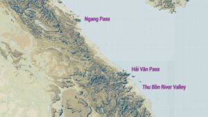
In the Tang dynasty period (618–907 AD), for instance, Chinese recorded information about Annan, Linyi 林邑 (a geographic container that covered the areas between the Hải Vân and Ngang Passes that were not under Chinese control, and that constantly changed), and Zhenla. However, Zhancheng 占城 (“Champa”), Sanfoqi 三佛齊 (“Kampuchea”), Xianluo (“Siam”), and Shepo 闍婆 (“Jaba” – on the Malay Peninsula), and Zhuawa 爪窪 (Java) were not part of the picture yet.
During the Song dynasty period, the geographic container of Linyi disappeared, as that area became part of the Lý dynasty empire. As a result, Chinese started dealing with the area to the south, which they labeled “Zhancheng.” In the centuries that followed, it did not matter who was in charge there, or where the “capital” was. Tribute that came from that area was tribute that came from “Zhancheng.”
“Sanfoqi” also emerged during the Song. This was a new “access point” into “Cambodia” from the southern coast at what is now Ha Tien. There are clear signs in the History of the Song that tribute from “Sanfoqi” came from different people and places, but that didn’t matter because it all came from that same “geographic container.”
One place where a geographic container was never established was the area around Angkor. Yes, you have one person, Zhou Daguan, who clearly traveled to Angkor and his book has “Zhenla” in its title (although there is no way to know if he came up with the title), but that’s because he traveled through the known “geographic container” of Zhenla to get there.
As for that geographic container of Zhenla, we have to understand why Chinese wrote about the places they did when they did. I get the sense that scholars have viewed the past like the present and think that Chinese knew about many places, but in fact they didn’t.
The reason why they knew about the Sambor Prei Kuk area (and labelled it “Zhenla”) during the Sui dynasty period was because there was an overland trade route to that area from places they controlled in what is now central Vietnam.
When they lost control of that territory, my guess is that they continued to interact with that “geographic container” from somewhere on the coast of what is now southern Vietnam, perhaps up the Saigon and Dong Nai rivers. As such, in later centuries, they probably didn’t get tribute from the same political center as they originally did, but that didn’t matter. It was still coming from the same “geographic container” of “Zhenla.”
What made me think of this just now is that I was reading about a place called Zhenlifu 真里富, a place that is recorded to be a vassal of Zhenla, and O. W. Wolters placed it on the north shore of the Gulf of Thailand in what is now Thailand.
Why did he do that? Because Zhenlifu is mentioned in Song dynasty sources, and he saw Angkor at that time as something like the “capital” of “Cambodia.” Therefore, if Zhenlifu was a vassal of Zhenla, since Zhenla was the “capital” of “Cambodia” during the Sui dynasty period and Angkor was the “capital” of “Cambodia” during the Song dynasty period, then Zhenla must refer to Angkor during the Song dynasty period, as “Zhenla = Cambodia.”
With that line of reasoning, imagining a vassal of Angkor in the area of Thailand made sense to Wolters.
However, Zhenla didn’t refer to “Angkor.” Because Zhenla never moved to follow the political changes in “Cambodia.” It still referred to a “geographic container” for polities in areas to the east of Angkor. Therefore, whatever vassals Zhenla had in the Song dynasty period, were most likely in that area as well. (If I remember correctly, I think “Piao,” which we associate with the “Pyu” kingdom in Myanmar is sometimes listed as a Zhenla vassal, but I think that points to an overland trade connection.)
Again, Chinese tributary names for places in Southeast Asia did not refer to “countries” or “polities” or their “capitals.” They referred to “geographic containers” within which all kinds of changes could take place, but none of that mattered. If tribute came from a “geographic container” than it was tribute from that “geographic container.”
That’s what Chinese tributary names in Southeast Asia referred to.
There has been this long-running trope in the Western scholarship on Southeast Asian history that “the Chinese saw Southeast Asia in terms of ‘kingdoms’” when in fact the “Southeast Asian reality” was of a world of “mandala polities” blah blah blah, and so therefore, we modern Western scholars are the enlightened ones because we can see the real Southeast Asia that those ethnocentric (and patriarchal!) Chinese failed to recognize. . .
In fact, it’s the modern Western scholars who have the problem. They have not been able to disconnect the concept of countries from Chinese tributary names (Zhenla = Cambodia).


I would argue a similar thing is going on with a lot of premodern names for the indigenes in the south of China. There is no way that there was a single 越 Việt group or 獠 Lão group or 猺 Dao group speaking the same language (or even language from the same family) in all the places these names were mentioned in premodern texts. The last one was used for anyone up in the mountains of southern China who was a swiddener or didn’t pay taxes, often speakers of Mienic languages, but not necessarily – sometimes Kradai and sometimes Hmongic.
Thanks for the comment. Right, so the important thing was that they were “swiddeners who didn’t pay taxes,” and 獠 Lão could be used to refer to those people in a given place over time regardless of what ethnicity they were or language they spoke and even if the population there changed. Right?
About Zhou Daguan’s journey, am I correct to think that: he followed a return trip of some sorts of “Zhenla” (in his view, regardless of its political center at the time) mission, then reached Angkor (that modern scholars confirm by details in his text) but he assumed the place was the same Zhenla as he read from his past Chinese texts? The title of his text (regardless of who coined it) is perhaps based on that logic.
Actually, the information is kind of confusing. In the introduction to the work, Zhou Daguan joins what appears to be a mission to Champa. He doesn’t explain why he then went to Zhenla.
聖朝誕膺天命,奄有四海,索多元帥之置省占城也,嘗遣一虎符百户、一金牌千户同到本國,竟為拘執不返。元貞之乙未六月,聖天子遣使招諭,𠈷𪜬從行。以次年丙申二月離明州,二十日自溫州港口開洋,三月十五日抵占城,中途逆風不利,秋七月始至,遂得臣服。至大徳丁酉六月回舟,八月十二日抵四明泊岸,其風土國事之詳雖不能盡知,然其大畧亦可見矣。
This is how it was translated recently by Peter Harris:
“The great Mandate of Heaven that the sacred dynasty has received includes everywhere within the four seas. Marshal Sodu set up a province in Champa, and sent out a general and a senior commander, who went there together. In the end they were seized and did not return.6 In the sixth month of the year youwei in the Yuanzhen reign period (1295), the sacred Son of Heaven dispatched an envoy with an imperial edict, and ordered me to accompany him.7”
In the second month of the following year, the year bingshen in the Yuanzhen reign period (1296), we left Mingzhou, and on the twentieth day of that month we set sail from the harbor at Wenzhou. On the fifteenth day of the third month we reached Champa, having been set back by adverse winds mid-journey. We arrived in Cambodia in the autumn, at the beginning of the seventh month.
We duly secured the submission of local officials. In the sixth month of the year dingyou in the Dade reign period (1297) we turned our boat around, and by the twelfth day of the eighth month we were back at Mingzhou, anchored off the coast.”
This part is not correct: “On the fifteenth day of the third month we reached Champa, having been set back by adverse winds mid-journey. We arrived in Cambodia in the autumn, at the beginning of the seventh month.” (三月十五日抵占城,中途逆風不利,秋七月始至)
1) the text does not mention “Cambodia,” and 2) the phrase “having been set back by adverse winds mid-journey” is modifying the information that comes after it, not the information before it, as Harris translated it, and 3) it doesn’t say that they arrived at “the beginning” of the seventh month.
I can see how he messed up. There is a character here, shi 始, which can mean “begin,” but in classical Chinese it is used to mean “then and only then” (like mới in Vietnamese, or 才 in Mandarin). It appears here: 秋七月始至 meaning “autumn-seventh-month-ONLY-arrive. Harris read this as “autumn-seventh-month-BEGIN-arrive.” That’s incorrect. The beginning of a month is yuechu 月初.
It should be “On the fifteenth day of the third month we reached Champa. Set back by adverse winds mid-journey, we ONLY arrived in autumn during the seventh month.”
Where did they only arrive in the seventh month? Presumably their final destination – Angkor, but the text doesn’t make that as clear as it could.
So, we don’t know why or by whose ships he went (from Champa to Angkor). But he did think he reached the Zhenla that he had been familiar with in his reading, right?
Actually, there is almost nothing that he writes that links what he saw to anything that had been written before. There is one brief quote in the preface where it cites the 13th-century Zhu fan zhi 諸番志, but that quote uses a name (Xianluo 暹羅) that only started to get used by the (later) Ming dynasty. I think the appearance of the name “Zhenla” in the title was also added during the Ming dynasty period.
This is how the preface begins:
“The Kingdom of Zhenla is also known as Zhanla. The country calls itself Ganbozhi [Kambuja]. The current Sagely Dynasty [the Yuan], based on the “Routes to the Western Barbarians,” names the country Ganpuzhi, which is presumably a close phonetic approximation of Ganbozhi.
“Setting sail from Wenzhou and steering a “Ding-Wei” compass bearing [South-Southwest], one passes the ports of the various prefectures off the coasts of Fujian and Guangdong, crosses the Sea of Seven Islands [Qizhou Yang], passes through the Sea of Jiaozhi, and arrives in Champa.
Furthermore, from Champa, with a favorable wind, one can arrive at Zhenpu in about half a month; this is its territory.”
Whose territory? Zhenla’s? Ganpuzhi’s?
Zhou Daguan believed that he was entering a place called Kambuja, and his dynasty, the Yuan, wanted to call it that (Ganpuzhi). If you read the text, you see that he passes through various “vassal kingdoms” before reaching a “capital.” However, his account, or the version we have, was only published after the Yuan, during the Ming dynasty period. I strongly suspect that the use of the name “Zhenla” in the title, came then, because why would Zhou Daguan title his work “A record of the customs of Zhenla” when the dynasty he served called it Ganpuzhi? It’s never a good idea to go against what a dynasty wants. . .
I think that there is a lot of evidence in Chinese sources to show that the term “Zhenla” did not have the sense of “all of Cambodia” as we know it today. It only referred to a part of it in the east which Chinese historically had interactions with.
Zhou Daguan was the first and only person to present the idea that there was something larger there, and that it was called “Kambuja,” but that name and idea did not stick.
Finally, I’m convinced that Sanfoqi 三佛齊 was also the name “Kambuja,” but I don’t see anyone using it to express the idea that it referred to “all of Cambodia.” Instead, it was what they called the “access point” to the Cambodian world from the south, heading inland from Ha Tien.
Oh, and what I have translated as “Routes to the Western Barbarians” (Xifan jing 西番經), is the name of an unknown text, but everyone since at least Pelliot translated this text in the early twentieth century thinks that it has something to do with “Tibetans.” That’s absolutely crazy! However, that’s for another day to discuss. . .
真臘國或稱占臘,其國自稱曰甘孛智。今聖朝按西番經名其國曰澉浦只,蓋亦甘孛智之近音也。自温州開洋,行丁未針,厯閩廣海外諸州港口,過七洲洋,經交趾洋,到占城。又自占城順風可半月到真蒲,乃其境也。又自真蒲行坤申針,過崑崙洋入港,港凡數十,惟第四港可入,其餘悉以沙淺,故不通巨舟。然而彌望皆修藤古木、黃沙白葦,倉卒未易辨認,故舟人以尋港為難事。自港口北行,順水可半月抵其地曰查南,乃其屬郡也。又自查南換小舟,順水可十餘日,過半路村、佛村,渡淡洋,可抵其地曰干傍取,城五十里。按諸番志稱其地廣七千里,其國北抵占城半月路,西南距暹羅半月程,南距番禺十日程,其東則大海也。舊為通商來往之國。聖朝誕膺天命,奄有四海,索多元帥之置省占城也,嘗遣一虎符百户、一金牌千户同到本國,竟為拘執不返。元貞之乙未六月,聖天子遣使招諭,𠈷𪜬從行。以次年丙申二月離明州,二十日自溫州港口開洋,三月十五日抵占城,中途逆風不利,秋七月始至,遂得臣服。至大徳丁酉六月回舟,八月十二日抵四明泊岸,其風土國事之詳雖不能盡知,然其大畧亦可見矣。
If the “Zhenla” title and the Zhu Fan Zhi citation were probably added later, (the first sentences) of the preface was also probably changed to reflect the view of ZhenIa (in older texts) = Ganbozhi / Ganpuzhi (in his text). Let’s say Zhou believed he had been only travelling through (from peripheries to the capital of) Ganbozhi / Ganpuzhi, then in his view he must have reached Ganpuzhi’s territory at Zhenpu, but for later editors Zhou reached Zhenla’s. The bigger question is how one could connect the “new” state to Zhenla in older texts. From geography only?
On the other hand, given the pieces of info: (Ganpuzhi seems to have been an official name from the Yuan court’s view), (Zhou claimed to be on an official mission and had access to some levels of Angkor inner areas), (Zhou went and came back directly China – Champa – Angkor – Champa – China), I assume that he was indeed on an official mission to Ganpuzhi, sent by the Yuan court. Then, the addition of Ganpuzhi into Chinese worldview did not stick perhaps because of the failure (of holding the empire against Ming) of Yuan. Still, afaik, the connection of the officially recognized Ganpuzhi and the (vague?) Zhenla was not made during the Yuan’s period. Do my assumptions above seems to be sound?
Lastly, as minor points, are we sure that (as some claims) Zhenpu was somewhere in Ba Ria Vung Tau and the river mouth where Zhou started to go inlands was somewhere on the east coast of Tay Nam Bo? Afair, you have theories about Ha Tien or even Sai Gon access points, right Prof.?
Thanks for the questions/comments!!
The name “Kambuja/Kampuchea” was “there” for centuries. The Song used the name Sanfoqi (pronounced at the time something like “Sam-fyut-tsia or Sam-fyut-tsai”) to refer to a place they were reaching from the southern coast. That was the word “Kambuja/Kampuchea.”
The Yuan apparently wanted to use the word Ganpuzhi. That’s “Kambuja/Kampuchea”.
In the account of Zhenla in the History of the Ming, it says that it’s also know as “Jianpuzhai.” That is also “Kambuja/Kampuchea.”
However, as I said above, once tributary names were created, they generally stayed the same. In the case of “Zhenla,” the main way they originally reached it was probably overland, but it looks like from the Song dynasty period onward, it was reached from what is now the Vietnamese coast.
So that area was associated with “Zhenla,” and like other tributary names, the name didn’t change. It didn’t matter what happened in the “geographic container” in that area or what the people there called themselves. When it came to official tributary relations, it was “Zhenla.”
So, yes, it looks like the Yuan wanted to use a different term, but when the Ming came to power, they said “No, we don’t do that. It has to continue to be Zhenla.”
As for – “are we sure that (as some claims) Zhenpu was somewhere in Ba Ria Vung Tau and the river mouth where Zhou started to go inlands was somewhere on the east coast of Tay Nam Bo” – I can’t remember what I thought when I looked at this closely, but it’s something like this.
And as for – “Afair, you have theories about Ha Tien or even Sai Gon access points, right Prof.?” – People definitely entered into the interior from the southern coast, and heading in from Ha Tien is the route that looks the most likely to me. As for where people headed in from the east coast, I don’t know. Zhou Daguan’s account is the first one of someone doing that. I think there is a mention somewhere of Longvek (below the Tonle Sap), but it’s not clear how that person got there (can’t remember where I saw that now).
When you get to the 1600s, there are navigational texts that survive, and from those you can see people mentioning both the Saigon and Mekong rivers, but I don’t think they contain information of traveling far up those rivers (at least I don’t remember that, maybe a bit up the Saigon River).
Finally, one important thing to point out is that there was very little contact with Zhenla over the centuries. It was clearly not all that important. By contrast, A LOT happened with Sanfoqi in the Song and early Ming.
So that raises the question: What were the Chinese contacting when they contacted “Zhenla.” Other than Zhou Daguan, it doesn’t appear to have been Angkor.
Thank you for explaining, Prof.!
To sum up what I understand so far, from the Song period, “Cambodia” exists in Chinese worldview partly in (the term of) Sanfoqi and partly in (the term of) Zhenla. But, as far as we know, Chinese did not explicitly connect Sanfoqi to the term of “Kambuja” (the connections are implicit in phonetics, geography, customs, tributes, etc.). Meanwhile, Zhenla was (not entirely correctly) equated to “Kambuja” only since the Ming period (as in “Jianpuzhai”). During the Yuan period, Ganpuzhi (as a term for “Kambuja”) was preferred and Zhou did go there in an official mission, while both Sanfoqi and Zhenla were mentioned only a few times in records ( https://leminhkhaiblog.com/zhenla-was-cham/ ).
If I understand correctly as above, I wonder:
a. Other than the two-way implicit connections between Ganpuzhi and Sanfoqi (in geography, etc), the Yuan did not make any connection of them to Zhenla? If yes, when Chinese during the Yuan contacted Zhenla, perhaps they contacted a polity centered around Sambor Prei Kuk (as many suspected) and separated it with “Kambuja”. The fact of contacting that polity as Zhenla has possibly been valid since earlier periods.
b. The Ming equated Zhenla and Kambuja (including Ganpuzhi in Yuan texts) by using geography, customs, etc. only?
c. In Chinese records, besides implicitly explored as the political center of “Kambuja” (as Zhou reached the capital of Ganpuzhi), Angkor was not explicitly mentioned? Perhaps Angkor was only implicitly described as a center of “Kambuja” through the alias of Sanfoqi.
Thanks again for the comments.
One big issue here is that we have Chinese names, but we really have no idea what the political reality in Cambodia was at the time those names were used.
Beyond the Chinese sources, the other source of information that we have for Cambodia are Sanskrit and Khmer inscriptions, and essentially, what we know about those inscriptions comes from what a single person, George Coedes, said about them (I’m exaggerating here to some extent, but you’ll see my point below).
In the first half of the 20th century, Coedes transcribed and translated into French the inscriptions, and he published those transcriptions and translations without images of the actual inscriptions. So, for the past ~100 years, people have been working with Coedes’s transcriptions/translations.
20 years ago, the École française d’Extrême-Orient (EFEO) initiated a project to digitize the inscriptions. A website was created around 2017, I think. It’s currently down (https://cik.efeo.fr/). And I’ve never seen any inscriptions on it. . .
I say this not to criticize the EFEO. I understand that digitizing the inscriptions (and checking everything) is time consuming and there are very few people in the world who have the expertise to do it. I’m saying this to point out that our understanding of “Cambodia” is definitely inadequate.
Coedes was very focused on seeing “one nation” with “one capital.” There are times where it would look to him like there were multiple rulers at the same time, and yet he would still create a narrative as if there was just one. This is the type of thing that scholars should have been able to address by going in and looking at the inscriptions themselves, and by now, they should have been able to work with those inscriptions in a searchable database. . . but none of this is the case. So, our understanding of Cambodia, I would argue, is still trapped within transcriptions/translations that were made a century ago.
With Chinese sources, they have always been available (at least in major research libraries). There just haven’t been enough people who can actually read them, and as a result, a lot of people have relied on early (mainly French) translations. But in the past 20 years, all of those sources have been digitized. So, if you can read Chinese, you can now go far beyond what people who could read Chinese in the past could do, and far, far, far beyond what the people who could only read early French translations, etc. of Chinese sources could do. However, the situation with Cambodia is still largely the way it was in the 20th century (I think there are some researchers within the EFEO who have access to the database they have been building, but that’s it, as far as I can tell).
Therefore, I would argue that we really have no idea what was there. Was it one “mandala” kingdom with “Angkor” at the center. Or was “Angkor” itself a group of semi-competing polities? Could it be that international trade was conducted inland below the Tonle Sap? That would make more sense then ships having to go all the way to Angkor. If so, what was the relationship between whatever place was doing the trading and “Angkor”? Was it just a “trading center” of Angkor, or was it more “independent”?
There are a lot of questions like these that my reading of the Chinese sources brings up, but there is no way to answer them when all we have are Coedes’s 100-year-old transcriptions/translations/interpretations (spread across various publications). Whatever people try to do will be inadequate as long as they can’t directly access the original inscriptions, and now, as long as they can’t access digitized (searchable) versions of those inscriptions.
That said, what we do know is that the Angkorean world went into “decline” (and we can see in Chinese sources that Sanfoqi did as well) in the 1400s and that the area near what is now Phnom Penh became a center of power. So, by the time the History of the Ming was recorded, there is no way that it was talking about Angkor when it mentioned “Zhenla.” Again, I think it was referring to a place that was accessed from the east, but I can’t say for sure what it was.
To return to your questions (A), there is only one mention of Sanfoqi in the History of the Yuan, and it is a statement saying that “Sogetu requested to summon Sanfoqi and other kingdoms, eight in total, but they did not comply” (唆都請招三佛齊等八國,不從。). The term “Zhenla” only appears 3 times. And I just realized that there is one time where it mentions “Ganbuxi” 干不昔 and says that it was ordered to submit (詔諭干不昔國來歸附). Further, there is no separate account of Sanfoqi or Zhenla. The only places that text has detailed information about are the places the Yuan attacked: Burma, Champa, and Java. So we have very little information about “Cambodia” in the Yuan period (other than Zhou Daguan’s very detailed travel account).
(B) At the end of the account of Zhenla in the History of the Ming it says “This kingdom calls itself Ganbozhi 甘孛智, which was later mistakenly [written] as Ganpozhe 甘破蔗. After the Wanli era [1573-1620, it was further changed to Jianpuzhai 柬埔寨” (其國自稱甘孛智,後訛為甘破蔗,萬曆後又改為柬埔寨). Where did this information come from? I have no idea, but this is why I feel like tributary names functioned like “geographic containers” or maybe “geographic labels” is a better term. When tribute came from the geographic space that the Chinese had long referred to as “Zhenla” and they said “We are from Ganbozhi” (one would assume that some Chinese intermediary wrote their documents for them), it is as if the people at the capital who recorded that information looked at a dropdown menu of tributary names and said, “Nope, no such place. Only ‘Zhenla’ for that geographic space.” And like governments today, the Chinese continued to work with that outdated computer system, and that dropdown menu never got updated. . .
(C) That’s right. Other than in Zhou Daguan’s account, there is no evidence of Angkor in Chinese sources. But, again, following my comments above about our inadequate knowledge of the political reality in Cambodia in the past, should we expect to see Angkor? If so, why? If that was not where international trade was conducted, for instance, then why would anyone mention Angkor?
Cool post!
Unfortunately, the Wikipedia article appears to have the mistaken interpretation.
https://en.wikipedia.org/wiki/Chenla
Also, just to clarify, would the mistake be comparable to viewing the terms “Levant” or “Anatolia” as referring to specific polities (incorrect) rather than specific areas/regions (correct)?
Thanks for the comment! I can’t profess to know much about the history of the usage of the terms “Levant” and “Anatolia.” However, I think a possible difference is that there is a bureaucratic element that is tied to the names that the Chinese gave to foreign kingdoms.
It’s like they created an Excel spreadsheet with a column for “kingdoms that present tribute,” and when they first set it up, they input “Zhenla,” etc.
And then they never changed those names. They later added more names to the column, like “Sanfoqi,” but they didn’t update the names that were already on the spreadsheet.
Another point that is important to make is that for the Song (960-1127) and the Ming (1368-1644) dynasty periods, we really only have information about tributary missions from the beginning years of the dynasties, and for the intervening Mongol Yuan period (1271-1368), there is very little information about tribute missions at all.
So, it’s like a dynasty would come to power, and they would look at the Excel sheet that the previous dynasty had used, and they would say, “Ok, go down to Zhenla and tell them to send tribute.” There was a general idea of where Zhenla was, but the information was not super clear because the information on the Excel sheet had been recorded much earlier.
In any case, the envoy would go to that general area, and would get someone to send tribute, but who exactly would that be? Was it a “king” from the exact same “kingdom” as before? Had no political changes taken place in the intervening centuries? Was “the capital” in the same place? New dynasties establishing a new capital in a new location is definitely something that happened in the past. Did the envoy even go inland to a “capital” or did he just make a deal with a powerful merchant at a coastal or downriver port?
None of that seems to have mattered. The most important thing was to be able to add a date to the “tribute received” column that was to the right of those names in the column of “kingdoms that present tribute” that had been input on the Excel spreadsheet centuries earlier.
I don’t know if “geographic container” is the best term for this, but what I am trying to explain is a combination of a bureaucratic category and geographic location.