
There is a major gap in the scholarship on the Cambodian empire of Angkor. That gap concerns Angkor’s access to the sea and international trade.
More specifically, scholars don’t really know how Angkor accessed the sea and engaged in international trade, but surely the most populous society in Southeast Asia in the 9th-14th centuries must have traded extensively with the outside world. How and where did that trade take place?
This gap in our knowledge was captured nicely in an encyclopedia entry on “Canals in the Mekong Delta: A Historical Overview from 200 C.E. to the Present” that historian David Biggs wrote way back in 2003:
Using aerial photography in 1931, an amateur archaeologist, Pierre Paris, discovered traces of canals crossing the western delta, from Rạch Giaf on the coast to Angkor Borei about 100 km to the northwest. What had previously been noted through ground surveys as straight creeks were actually the remaining traces of human-constructed waterways. Louis Malleret, a former director of the French l’Ecole Francaise d’Extreme-Orient, led digs in the 1940s and 1950s at canal sites discovered through aerial and ground surveys. Malleret’s work and that of successive Vietnamese and international researchers has proven through comparison of pottery shards and other means that these canals dated to roughly 200-400 C.E. . . (1)
. . . There is no further evidence of major canal projects or dense settlement in the Mekong Delta for more than 1000 years after the decline of “Fu Nan.” From the ninth to fourteenth centuries, the upstream kingdom of Angkor controlled the entire region and conducted its major trade routes by highways that stretched westward into present-day Thailand and to the west coast of the Isthmus of Kra. Archaeological evidence near present day coastal towns of Trà Vinh and Sóc Trang [Trăng] suggest that river ports here conducted small-scale local trade with Southeast Asian and Chinese merchant ships. One possible explanation for the lag in development of the Mekong Delta after Fu Nan could be that the very same waterways and flat landscape that facilitated easy transportation also allowed easy attack by enemy fleets. Steles at Angkor Thom (Siem Reap) depict naval battles with ships from Champa that attacked the Khmer capital by way of the Mekong River. The numerous islands in the Gulf of Thailand also provided easy harbor for all manner of pirates-Malay, Siamese, Chinese, European. . . (2-3)
. . . In 1818, still worried about the threat of Siamese invasion, King Gia Long ordered his military governor in the delta, Thoại Ngọc Hâu [Hầu], to assemble an army of conscript laborers to dig a canal 67 kilometers from a new river citadel at Châu Đôc [Đóc] to Hà Tiên. More than 50,000 laborers worked for 5 years and through several Khmer-led rebellions to complete the waterway. . . (3)
. . . The period of colonial dredging contracts with a mechanical dredging firm lasted from 1894-1945. During the peak of colonial expansion from 1894-1930, the colonial regime dredged some of the major “transverse” waterways connecting the lower branch of the Mekong or Hậu Giang with the Gulf of Thailand. (4)
Biggs is an historian of the modern era, so what he wrote above was not based on his own research, but instead, was a summary of the extant scholarship for a field that was outside of his area of expertise. I am citing it here because I think it is a succinct summary of the state of knowledge about canals in the history of the Mekong Delta at that time (2003), and although studies on ancient canals in that region were conducted in the years after Biggs wrote the above information, those studies largely confirmed the dating of those canals to the first millennium AD, rather than alter the above narrative.
Further, as Biggs notes, the topic of historical canals and waterways in the Mekong Delta has mainly been addressed by archaeologists, rather than historians. Hence, the title of this blog post.
What have archaeologists, and to a lesser extent, historians, argued? They have argued that canals were important for an early kingdom that was referred to in Chinese sources as “Funan,” which was perhaps centered in the area of what is now Angkor Borei. In particular, scholars have argued that there were early canals that connected an early political center at Oc Eo to the sea, as well as to a larger inland polity to its northwest at Angkor Borei.
Then, parallel with the rise of Angkor at the end of the first millennium, those canals fell into disuse.
Not much then seems to happen for the next millennium until the early nineteenth century, when the Nguyễn dynasty dug various canals in that region, one of the most well-known being the Vĩnh Tế Canal, which linked Hà Tiên on the coast with Châu Đốc, which is on the Bassac River, a distributary of the Mekong. From Châu Đốc, one can easily proceed up the Bassac River to Phnom Penh and then onward to the Tonle Sap.
As for how Angkor interacted with the outside world, scholars do not have a clear sense of that. They make comments about riverine networks that connected to coastal trading ports, but do not provide specifics.
For many scholars, the Record of the Customs of Zhenla (Zhenla fengtu ji 真臘風土記), a late-thirteenth century account of a journey to Angkor by Chinese envoy, Zhou Daguan, has been important, as Zhou Daguan records traveling up the Mekong and the Tonle Sap to the area of Angkor.
The information about that journey is recorded in the preface to that work, where it indicates that the journey from the coast to Angkor took over 25 days.
That preface records some other information that is important, which I have not seen scholars consider carefully, and we’ll discuss that below.
For now, however, let us just consider this narrative. We are supposed to believe that canals were important for connecting the Gulf of Thailand with inland areas in the Mekong Delta in the first millennium AD, and from the early nineteenth century to the present, but that in between, there was a millennium when they were apparently not employed.
Further, the first part of that millennium coincides with the time when Angkor was at its peak.
Ok. . . That makes absolutely no sense. So, why do people think that way?
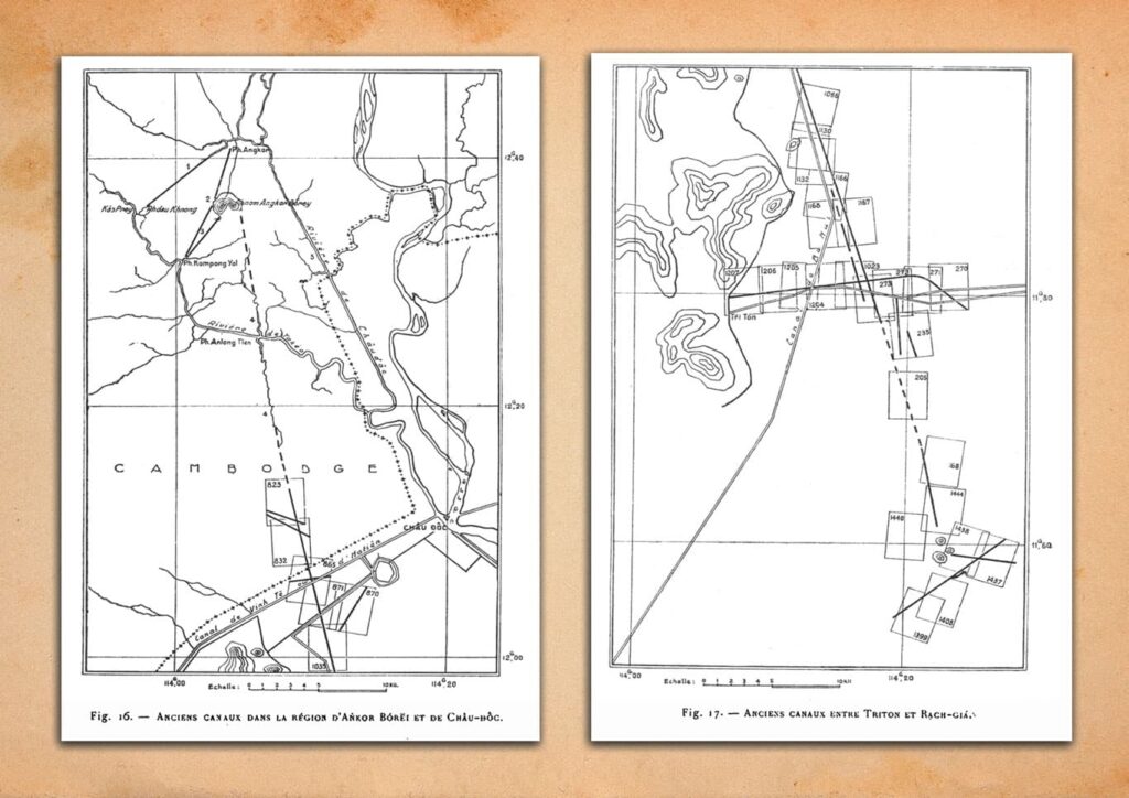
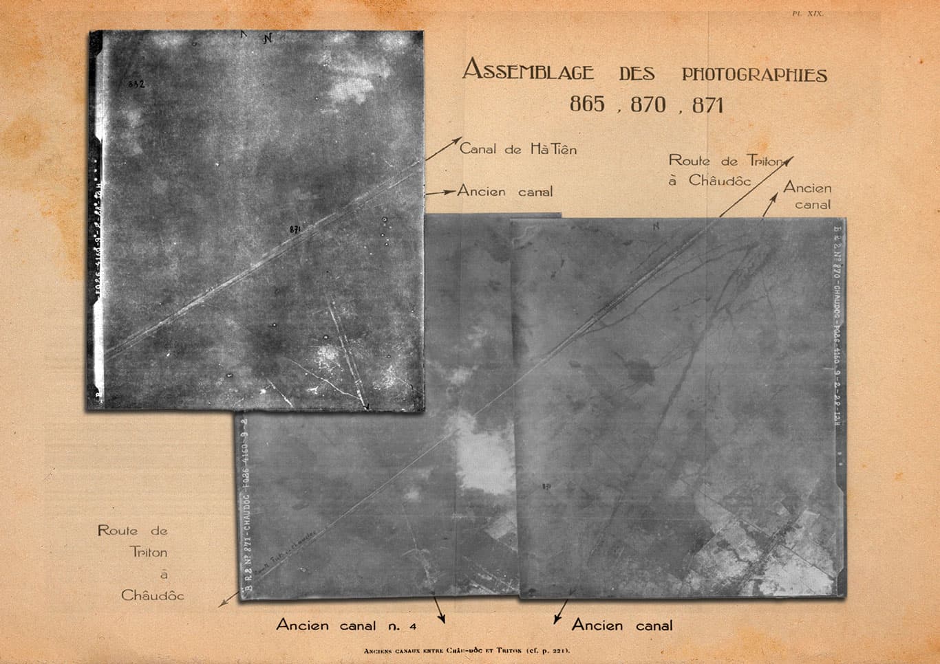
As Biggs notes above, the ancient canals that scholars have studied were first discussed by amateur archaeologist Pierre Paris in 1931 in a note that he published in the Bulletin de l’Ecole française d’Extrême-Orient in 1931, with two follow-up notes published in 1941 (here and here).
Paris examined aerial photographs that had recently been made and he saw some lines of what he argued were ancient canals, such as the one extending to the northwest towards Angkor Borei from Oc Eo.
In that first note, Paris made the following comments:
Quel est l’âge de tous ces canaux? Certainement antérieur à la colonisation annamite. A cette époque, ils ne devaient déjà plus attirer l’attention d’un observateur au sol, car les Annamites paraissent les avoir complètement dédaignés. En effet, le canal des Sept Montagnes suit parallèlement le canal n° 4, sur 13 km. De même, les canaux de Vinh-tê, de Mac Can Dung et de Nui Ba Thê coupent et recoupent respectivement, sous des angles quelconques, les canaux transversaux signalés aux paragraphes 10, 20, 40.
Un seul de ces anciens canaux a «réussi». C’est la rivière actuelle d’Ankor Bórěi à Châu-doc, numérotée 5 sur la carte.
What is the age of all these canals? Certainly earlier than Annamite colonization. By that time, they must already no longer have attracted the attention of an observer on the ground, for the Annamites seem to have completely ignored them. In fact, the Seven Mountains canal runs parallel to canal no. 4 for 13 km. Likewise, the Vĩnh-tế, Mac Can Dung, and Núi Ba Thê canals cut across and recut, at various angles, the transverse canals noted in paragraphs 1, 2, and 4.
Only one of these ancient canals “succeeded”: the present Ankor Bórěi-to-Châu-đốc river, numbered 5 on the map. (1931, 223)
And then in one of the later notes, he stated the following:
Si l’on s’étonne que les rois du Fou-nan n’aient pas choisi, pour relier leur capitale au Golfe de Siam, un trajet plus court débouchant vers Hà-tiên ou la baie de Hôn Chông (Cây Dircrag), il faut penser aux difficultés qu’ont eues les Annamites à creuser, les Français à approfondir le canal de Vînh-tê, dans l’argile compacte de la région à l’Ouest du massif de Triton.
If one is surprised that the kings of Funan did not choose, to link their capital with the Gulf of Siam, a shorter route opening toward Hà Tiên or Hòn Chông Bay (Cây Dương), one must think of the difficulties the Annamites had in digging, and the French in deepening, the Vĩnh Tế canal in the compact clay of the region west of the Triton massif. (1941, 369)
What do we see here? We see exactly the idea that scholars still uphold today, namely that, as I wrote above: canals were important for connecting the Gulf of Thailand with inland areas in the Mekong Delta in the first millennium AD, and from the early nineteenth century to the present, but that in between there was a millennium when they were apparently not employed.
Further, Paris pointed to certain “illogical” decisions on the part of people in the past. The shortest routeto the coast was to a place like Hà Tiên, and yet, no one seemed to have ever thought of that until the Vietnamese built the Vĩnh Tế Canal in the early nineteenth century.
However, Paris saw the Vietnamese as illogical as well, arguing that they ignored the traces of old canals, and in one place they even dug a new canal parallel to an ancient canal presumably without realizing that.
In other words, this is where the narrative of the history of canals in this region begins, and while, as I indicated above, I find the narrative itself to be illogical, it is based on the idea that the historical inhabitants of the region were illogical. 😊
I, on the other hand, work on the assumption that everyone in every age is logical. And I see clear evidence of such logic in this area in the past at the time when the canals that Paris identified supposedly fell into disuse. A key for understanding this is that other piece of information in the preface of Zhou Daguan’s account of a journey to Angkor.
In particular, the preface cites an earlier text, Zhao Rukuo’s 1225 work, the Treatise on the Various Barbarians (Zhufan zhi 諸蕃志), for the following information about the places one can reach from Zhenla by traveling in the four directions:
按諸番志稱其地廣七千里,其國北抵占城半月路,西南距暹羅半月程,南距番禺十日程,其東則大海也。
According to the Treatise on the Various Barbarians, [Zhenla’s] land spans 7,000 leagues. Its kingdom reaches Zhancheng [Champa] to the north, a half-month overland; to the southwest it is separated from Xianluo [Siam] by a half-month journey; to the south it is separated from Panyu by a ten-day journey; to its east is the Great Sea.
There are various philological issues that have to be addressed with this passage, and I did so two years ago in a post entitled “I FINALLY found Sanfoqi.” Anyone interested should feel free to consult that post (and it’s in the second “Rescuing History from Srivijaya” article as well).
All we need to understand for the purpose of the discussion here is that the very preface that records information about Zhou Daguan’s journey of more than 25 days from probably the mouth of the Mekong to Angkor, also cites another source that says nothing about the distance to the east to the sea, but that one could reach a place in the south in 10 days.
My argument is that the place in the south was on the coast, and in the above blog post I provide evidence to support that idea.
So, what was that southern route? I think it was a canal in precisely the place which Paris argued was the most logical place for a canal, that is, one that extended from someplace inland to Hà Tiên.
In fact, I would argue that it was precisely where the Vĩnh Tế canal was dug in the nineteenth century.
1) Just because Paris claimed that there is evidence of Vietnamese in the early nineteenth century supposedly not seeing an ancient canal and building a new one alongside where the ancient canal ran does not mean that they always failed to see where an old canal was located (or even that their decision to not build the canal in the same place was because they were unaware of the older canal).
In his early-nineteenth-century Unified Gazeteer of Gia Định Citadel (Gia Định thành thông chí 嘉定城通志), scholar-official Trịnh Hoài Đức does mention ancient canals in that area. So, Vietnamese in the early nineteenth century, when the Vĩnh Tế and other Canals were dug, did have the ability to perceive ancient canals.
2) That Paris did not see signs of an ancient canal paralleling the Vĩnh Tế Canal that the Vietnamese had “ignored” could be precisely because the Vietnamese constructed the canal over one that had been used during the Angkorean period. Further, given that the French had re-dredged the canal in 1914 makes it even less likely that there would be signs of an ancient canal parallel to it in the aerial photography of the 1930s as both the Vietnamese and French projects likely expanded whatever remained of a canal that had been in use earlier.
3) If the Vĩnh Tế Canal follows the path of an older canal, we probably have no way of knowing how old the original canal was. However, if such a canal that cut across existing canals and made the shortest connection to the coast was dug somewhere near the end of the first millennium AD and was overseen by people from, or in alliance with, Angkor, then it could help explain the rise of Angkor and the decline in use of the canals that connected Angkor Borei to the coast via Oc Eo.
People in the past were logical. By contrast, the idea that the Angkorean empire did not have access to the Gulf of Thailand by means of a canal while the earlier polity of Angkor Borei did, and the later Nguyễn dynasty did, is extremely illogical.
Further, we have historical evidence which points to such a canal.
