

In recent years I’ve written some articles about early Southeast Asian history, and I don’t like how have written those articles.
When you write for a “scholarly” audience, there are certain things that you are expected to do, and in my case, I am going through a lot of sources, particularly Chinese, and coming up with very different views of the past than my predecessors. I therefore have to carefully document everything and talk about the historical sources, explain what’s in the sources, explain how my argument is based on those sources, etc.
I think the result is a pretty unenjoyable read, and the number of people in the world who have worked closely with the sources I cite is tiny. So, the whole process is pretty frustrating. I would much prefer to just write a new history of early Southeast Asia and cite the sources. However, I have to get the “scholarly” stuff out first.
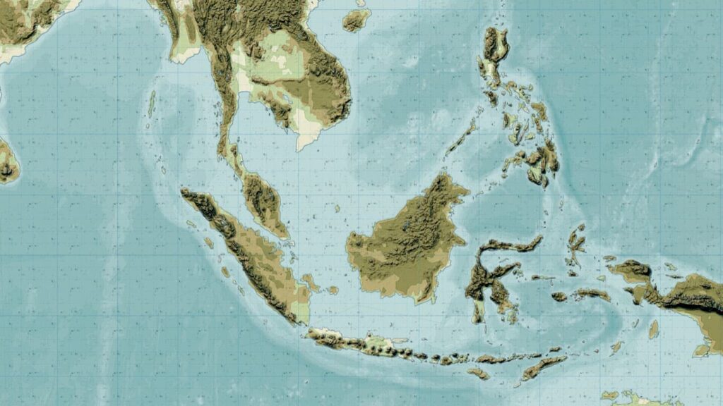
While waiting for that to happen, I want to write here about how I see early Southeast Asian history based on the research I’ve done and to point out some things about geography that I have not seen historians talk about before.
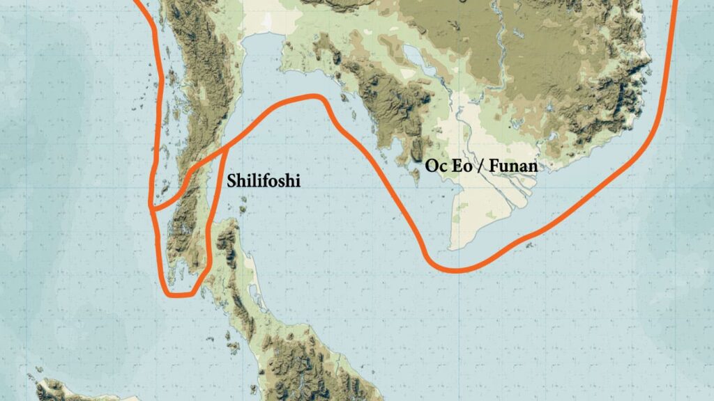
In the early centuries AD, there were trade routes that went along the coast of what is now mainland Southeast Asia and across the upper part of the Malay Peninsula. It is in this general area that a place that Chinese referred to as Shilifoshi was located, and that was a place that was visited by Buddhist monks.
The area of what is now parts of Cambodia and southern Vietnam were also home to a vibrant society (Oc Eo, Funan, etc.)
Then by around the 800s-900s, people had found a better place to cross the Malay Peninsula further to the south in the area that stretches from Kedah in the west to Songkhla in the east. What made this area better?
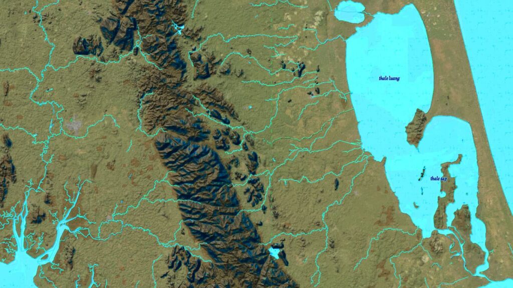
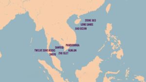
Water. If you look at the maps below, you can see that there were many rivers in this region, as well as three bodies of water that make up what is now referred to as Lake Songkhla.
Historians have written a lot about the importance of the sea in Southeast Asian history. However, I would argue that there was a geographical setting that was even more important than the sea alone, and that was the geographical setting that we find in the middle of the Malay Peninsula.
There, not only is there sea on both sides, but there is also large inland bodies of water and numerous rivers and streams. In other words, more than just being connected to a coast, this area is home to a major aquatic network of lakes, rivers, streams, canals, and coasts.
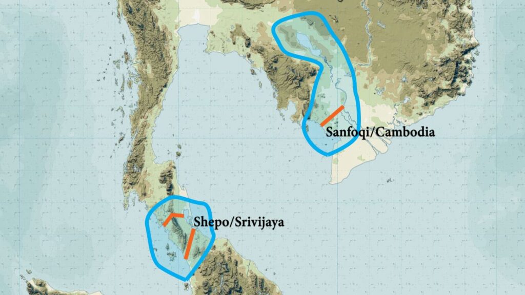
This made the central area of the Malay Peninsula extremely important, and it is here, I argue, that a place that is referred to in inscriptions as “Srivijaya” or “Srivishaya” was located. This was probably a city-state, and in that area, there were other competing city-states, but at times, Srivijaya/Srivishaya was the most dominant.
While this name was used in some inscriptions, you can’t find Chinese or any other people leaving a term in their historical sources that is the name “Srivijaya.” Instead, I argue that the term “Shepo” (coming from a word like “Jaba” or “Java”) in Chinese sources is a reference to the area that Srivijaya at times dominated.
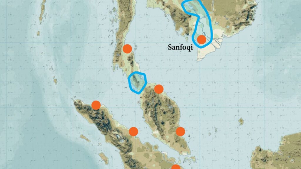
Shepo had a major rival, and that was “Cambodia.” The term that the Chinese used to refer to this place starting in the 900s was “Sanfoqi.” Sanfoqi did not refer to Angkor, but instead, to the main coastal access point to the Cambodian world, the area around what is now Hà Tiên, on the current Vietnam-Cambodian border.
The area of what is now Cambodia, like the Malay Peninsula, was home to various city-states, the most important of which could be found inland and which we refer to as Angkor. Further, that this area was important and powerful was also related to its geography. Like the middle of the Malay Peninsula, the area of Cambodia was one which had coastal access, but that also consisted of a network of rivers, streams, canals, and inland bodies of water.
Indeed, the central part of the Malay Peninsula and the area of what is now Cambodia both shared this unique geographic setting, and it is therefore not surprising that these two places became rich and powerful, and that they competed.
These are also the places that foreign merchants visited. Ships that could sail across oceans were expensive to build and maintain. Most people in the region used ships that were designed for coastal and riverine trade. However, if we go back to around 1,000 AD, we would have found large ships that sailed between the Middle East and China.
Where did those ships go? We can see from Arabic sources that they went to Kedah, and then to Tioman Island to get water, and then up to Cambodia, before heading for China. In other words, they stopped to trade at both of these rival trading areas.
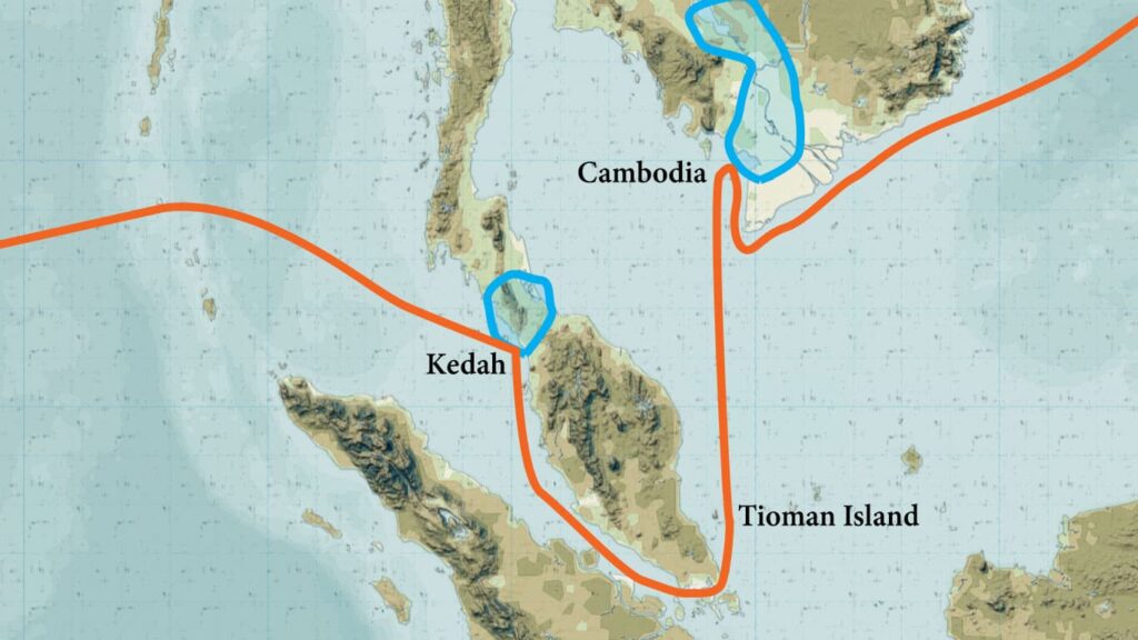
In the early eleventh century, the Chola kingdom attacked both sides of the central area of the Malay Peninsula, including its most prosperous city-state, Srivijaya, which I argue was probably located in the area of what is now Songkhla.
That area never fully recovered. It looks to me like some South Asian people probably stayed in the region. Meanwhile, the trading center at Sanfoqi on the Cambodian coast created a network of coastal allies that spread down the Malay Peninsula and up through the Straits of Melaka to the northern tip of Sumatra, thereby bypassing what was left of Srivijaya/Shepo.
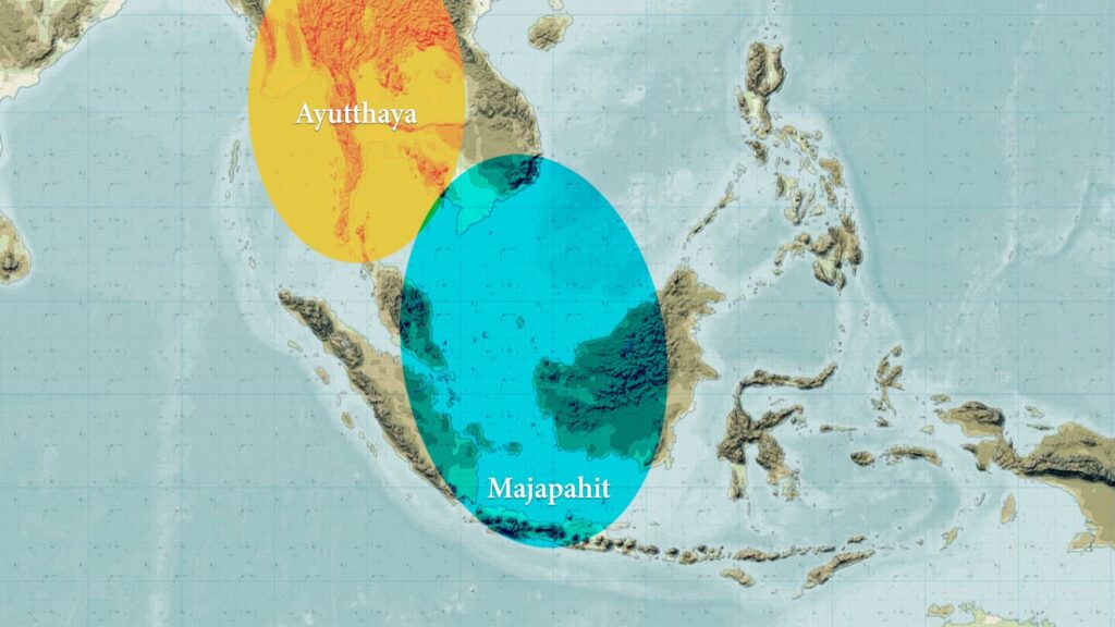
That situation, however, did not last all that long, because in the fourteenth century, two other kingdoms expanded their influence and control into the area that had previously been dominated by Shepo/Srivijaya and Sanfoqi/Cambodia.
In particular, the Javanese kingdom of Majapahit attempted to control areas on Sumatra, the Malay Peninsula, Brunei, and the area of Sanfoqi on the Cambodian coast as well.
Meanwhile, the new kingdom of Ayutthaya, spread its control eastward to Angkor and southward into the central Malay Peninsula.
Ayutthaya was another city-state among rival city-states. It was also in a geographical setting that was somewhat similar to the water worlds of the mid-Malay Peninsula and Cambodia. There were no large bodies of water, but there were many rivers, streams, and canals, as well as coastal access.
Ultimately, Ayutthaya came to control the area where Angkor was located as well as the area around Lake Songkhla. The two prominent trading areas of Shepo and Sanfoqi lost their influence.
As for Sanfoqi, many years later, in the 1600s, Chinese fleeing the Qing dynasty would establish a base at its former port, where Hà Tiên is today, and in the early nineteenth century, the Nguyễn dynasty would re-open some of the old canals that had not been maintained.
However, by that point, Westerners were active in the region and their presence would transform the dynamics of trade and politics in the years that followed.
What I have written here is based on the research that I have done over the past few years, and I can document every statement that I have made.
However, if we put the historical evidence aside, and just take a step back and think about the geography, then what I have said above is also just extremely logical.
I don’t think I’ve ever read anything anywhere about the Lake Songkhla region being important in the past. But think about that!! In an age when the main means of travel was by small boats on rivers, lakes, and along coasts. . . how could it be that somehow no one noticed that the Lake Songkha region is a perfect location for that means of transportation, and therefore, a perfect place to establish a kingdom that could benefit from all of the access that the aquatic network there offered?!!!
The Songkhla-Kedah region was geographically one of the best places in Southeast Asia for the technology of the first millennium AD!!!
And why is it that in the existing accounts of Vietnamese history, when the topic of Chinese settling at Hà Tiên and Saigon in the seventeenth century comes up, we are told that those were more or less undeveloped areas and that’s why they were allowed to settle there? Or that when the Nguyễn dynasty dredged the Vĩnh Tế Canal in the early nineteenth century that this was some radical idea to transform the land?
None of this makes any sense!! The current Cambodian/southern Vietnam coasts were literally at the center of a trans-Asian trade network. The places where Chinese settled in the seventeenth century were not undeveloped, they were just trading posts that had fallen on hard times following Ayutthaya’s expansion into Cambodia.
And the Nguyễn’s dredging of a canal was not something new. In the early nineteenth century, Nguyễn dynasty official Trịnh Hoái Đức noted the existence of old, overgrown, canals in that region. There were likely many. As such, the Vĩnh Tế Canal was probably more “re-opened” than created from scratch.
If I had Elon Musk’s wealth, I would take extensive Lidar images of the areas of the middle of the Malay Peninsula and the area from Hà Tiên to Angkor. I can guarantee you that there is a lot there to be found.
For centuries, these were the best geographic locations in the region.

Nguyễn historians obviously have agenda, and the “construction” of Vĩnh Tế canal was one amongst the sea of hideous affairs that stemmed from the expansion of the Nguyễn into Cham territory.
Really wonder how the Philippine port kingdoms/city states fared during this later period [Ayutthaya vs Majapahit] since it seems most ‘roads’ going west were blocked by the influences of the two rival polities. Accoridng to Nagarakertagama, Majapahit vassalised Philippine polities such as Lusong [Saludong in Nagarakertagama] and Sulu [Solot in Nagarakertagama]. Earlier Dade Nanhai Zhi recorded the Phlippine kingdoms to have been administered/controlled by Brunei/Foni Kingdom.
But Roderich Ptak noted that during the Yuan Dynasty, there were disruptions in the Xihanglu [west ship route], when the Mongols were attacking mainland Southeast Asian kingdoms, and many merchants proceeded to the Donghanglu [east ship route] where they penetrated the markets in the Philippines and Eastern Indonesia. That gave the Philippines a fair share in the regional economy and politics. But that was during the 1270s-1360s. The rise of Majapahit and Ayuthaya meant there were shifts again in the trading patterns, and the Ming declared the Haijin ban too. I wonder how that affected the Philippine kingdoms cuz Lusong and Sulu would become prominent during the Ming. It was via the Lusong [aka Lucoes] traders and sailors that the Portuguese would find a route to Macau/Southern China, and the Lusong soldiers were also present in the Burma-Siam wars.