

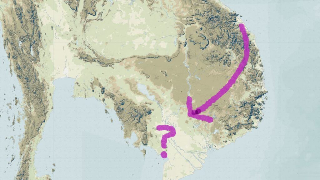
I recently learned/realized that during the Tang dynasty period, there was an overland trade route that went from what is now central Vietnam over to Cambodia and then south to the sea at (I believe) the area around what is now Ha Tien.
Now that I am aware of that, certain details in the historical record now make much more sense to me, such as the account of Zhenla in the Old History of the Tang and in the History of the Song.
Zhenla is a place which many scholars equate with “Cambodia,” but in the previous post on “Chinese Tributary Names as Geographic Containers,” I pointed out why that is not accurate.
I hope this post will make that point clearer.
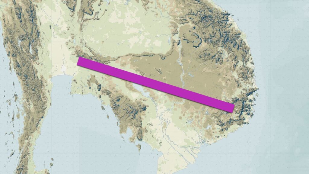
Let’s begin by looking again at the overland trade route from central Vietnam to Cambodia.
自驩州西南三日行,度霧溫嶺,又二日行至棠州日落縣,又經羅倫江及古朗洞之石蜜山,三日行至棠州文陽縣。又經漦漦澗,四日行至文單國之算臺縣,又三日行至文單外城,又一日行至內城,一曰陸真臘,其南水真臘。又南至小海,其南羅越國,又南至大海。
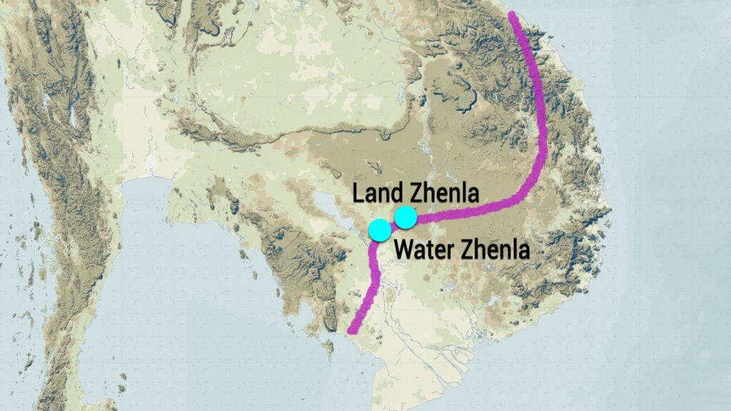
From Huan Prefecture [Huanzhou], travel southwest for three days, cross Wuwen Ridge, then another two days to reach Riluo District in Tang Prefecture [Tangzhou]. Pass through the Luolun River and Stone Honey Mountain in Gulang Grotto, then three days to Wenyang District in Tang Prefecture. Pass through Lili Ravine, then four days to Suantai District in the Kingdom of Wendan, another three days to the outer city of Wendan, and one more day to the inner city, also known as Land Zhenla, with Water Zhenla to its south. Continue south to the Small Sea, south of which is the Kingdom of Luoyue, and further south to the Great Sea.
As I wrote in an earlier post, I think this passage should begin by stating “From Huanwang” instead of Huanzhou, however, what I am going to say here still makes sense regardless of where this route began.
A key detail I want to point out is that there is detailed information about this route from Vietnam to Wendan/Land Zhenla. After that, the information is much more general: “Continue south to the Small Sea, south of which is the Kingdom of Luoyue, and further south to the Great Sea.”
I think that is describing a route down to the sea around what is now Ha Tien.
Further, it makes sense that the first part of this overland route is detailed and the end is not. Since it was an overland route and the Chinese were at one end of it in their empire in what is now Vietnam, they knew the places closer to that end better than the places on the other end, and probably never, or only rarely, ever went all of the way to the coast.
When we look at the account of Zhenla in the Old History of the Tang, which contains information from the time when this route still extended from Chinese-controlled territory in what is now Vietnam, we can see evidence of that route.
真臘國,在林邑西北,本扶南之屬國,「崑崙」之類。在京師南二萬七百里,北至愛州六十日行。其王姓剎利氏。有大城三十餘所,王都伊奢那城。風俗被服與林邑同。地饒瘴癘毒。海中大魚有時半出,望之如山。每五六月中,毒氣流行,即以牛豕祠之,不者則五穀不登。其俗東向開戶,以東為上。有戰象五千頭,尤好者飼以飯肉。與鄰國戰,則象隊在前,於背上以木作樓,上有四人,皆持弓箭。國尚佛道及天神,天神為大,佛道次之。
The Kingdom of Zhenla is located to the northwest of Linyi. It was originally a vassal state of Funan and is of the Kunlun 崑崙 type. It is located 20,700 leagues south of the capital [Chang’an]. To its north, it is a sixty-day journey to reach Aizhou.
The king’s surname is Chali clan 剎利氏 [Kshatriya]. There are over thirty large fortified citadels, and the royal capital is Yishena citadel [Isanapura]. Their customs and clothing are the same as those of Linyi.
The land is rife with poisonous miasma. In the sea, great fish sometimes emerge halfway out of the water; when viewed, they resemble mountains. Every year during the fifth and sixth months, when pestilential vapors circulate, they offer sacrifices of cattle and swine to them; if they do not, the five grains will not ripen.
It is their custom to open doors facing the east, as they regard the east as the superior direction.
They possess five thousand war elephants; the especially fine ones are fed with rice and meat. When they go to war with neighboring states, the elephant corps takes the vanguard. Wooden towers are constructed upon the elephants’ backs, carrying four men, all wielding bows and arrows.
The country reveres both Buddhism and the Celestial Deities (Hindu gods); the Celestial Deities are considered primary, while Buddhism is secondary.
So, why are these references made here to “Linyi,” a place which as I have explained in this post on “Locating Linyi” was located in what is now central Vietnam?
Because Chinese accessed Zhenla through the overland trade route that passed through that area, and traders and envoys from Zhenla undoubtedly accessed the Chinese world through the same route.
The text says that Zhenla was to the “northwest of Linyi” but it also says that it was a sixty-day journey north from Zhenla to Aizhou, which was in central Vietnam. Those two pieces of information contradict each other (I suspect that the northwest was a typo for southwest), but they both point to a place that was connected by land to the area of central Vietnam.
In other words, they both support the idea that in this time period, Chinese reached places in Cambodia via an overland route from their imperial territory in Vietnam.
And how would one know that there were thirty large citadels? Because Chinese had traveled across the overland trade route and passed by those citadels. And the same logic also explains why the clothing of the people of Zhenla was compared to that of the people of Linyi.
The only detail here that challenges what I am saying is the comment that “in the sea” there were great fish that “sometimes emerge halfway out of the water; when viewed, they resemble mountains,” however that might have been a reference to the Irrawaddy dolphin (aka the Mekong dolphin) which can travel quite far up fresh-water rivers, and could have been a piece of lore from that region which Chinese only knew vaguely about, just as their knowledge of the route beyond Wendan/Land Zhenla was also vague.
武德六年,遣使貢方物。貞觀二年,又與林邑國俱來朝獻。太宗嘉其陸海疲勞,錫賚甚厚。南方人謂真臘國為吉蔑國。自神龍以後,真臘分為二:半以南近海多陂澤處,謂之水真臘;半以北多山阜,謂之陸真臘,亦謂之文單國。高宗、則天、玄宗朝,並遣使朝貢。
In the sixth year of the Wude reign [623 AD], they sent envoys to present local products as tribute. In the second year of the Zhenguan reign [628 AD], they came again to court to offer tribute alongside the Kingdom of Linyi. Emperor Taizong commended them for the arduous fatigue of their journey by land and sea, and bestowed very generous rewards upon them.
The people of the south refer to the Kingdom of Zhela as the Kingdom of Jimie 吉蔑 [Khmer].
From the Shenlong era [705–707 AD] onwards, Zhela was divided into two parts: The southern half, which is near the sea and abounds in marshes and lakes, is called Water Zhenla.
The northern half, which abounds in mountains and hills, is called Land Zhenla; it is also known as the Kingdom of Wendan.
During the reigns of [Emperor] Gaozong, [Empress] Zetian, and [Emperor] Xuanzong, they all sent envoys to pay tribute.
Again, why present tribute together with Linyi? Because your envoys arrived in Linyi across the overland trade route, and the two delegations probably then made contact with the Chinese in the area of Vietnam and proceeded on from there.
The final section of this account talks about Water Zhenla.
水真臘國,其境東西南北約員八百里,東至奔陀浪州,西至墮羅鉢底國,南至小海,北即陸真臘。其王所居城號婆羅提拔。國之東界有小城,皆謂之國。其國多象。元和八年,遣李摩那等來朝。
The Kingdom of Water Zhenla: Its territory spans approximately eight hundred leagues in all directions. To the east, it reaches Bentuolang [Panduranga]; to the west, it reaches the Kingdom of Duoluobodi [Dvaravati]; to the south, it reaches the Little Sea; and to the north lies Land Zhenla.
The city where the King resides is called Poluotiba.
On the eastern frontier of the country, there are small walled citadels, all of which are referred to as kingdoms. The country abounds in elephants.
In the eighth year of the Yuanhe reign [813 AD], they sent [an envoy named] Li Mona and others to come to court.
As I will explain below, I think we always have to be a bit careful with the geographic formula “to the east. . ., to the west. . ., to the north. . ., to the south. . .” because my sense is that Chinese scholars would add place names that seemed logical when they didn’t know for sure.
If we take the above information literally, then the territory of Water Zhenla would look like this:
If, however, we see from the information in the Tang-era itinerary above, that 1) Chinese knew where Land Zhenla was (my guess is that it was around Sambor Prei Kuk), and that 2) they knew where the Little Sea was (which I think the Tonle Sap is the only obvious option), and that 3) they knew that the Little Sea was to the south of Land Zhenla; then if Water Zhenla was between Land Zhenla and the Little Sea, then what we see is that all of this is talking about a very small part of what is now Cambodia.
However, that small part was all on an important overland trade route.
Then, at the end of the Tang dynasty period, the area of Vietnam became autonomous and was no longer part of the Chinese empire.
That being the case, it is unlikely that Chinese would have still used that important overland trade route that had previously reached lands they had controlled in what is now central Vietnam.
In which case, we should expect to see the information recorded about Zhenla in the subsequent History of the Song to position it differently. And that is exactly the case.
真臘國亦名占臘,其國在占城之南,東際海,西接蒲甘,南抵加羅希。其縣鎮風俗同占城,地方七千餘里。有銅臺,列銅塔二十有四、銅象八以鎮其上,象各重四千斤。其國有戰象幾二十萬,馬多而小。
The Kingdom of Zhenla 真臘 is also called Zhanla 占臘.
The kingdom is located to the south of Zhancheng [“Champa”]. To the east, it borders the sea; to the west, it connects with Pugan [“Bagan”]; to the south, it reaches Jialuoxi [“Grahi” – scholars think that this is on the Malay Peninsula. I don’t agree with that, but that’s for a later post].
The customs of its districts and towns are the same as those of Zhancheng. The territory extends for over 7,000 leagues.
There is a bronze terrace, upon which are arranged twenty-four bronze pagodas and eight bronze elephants that stand guard over it. Each elephant weighs 4,000 catties.
The country possesses nearly 200,000 war elephants; horses are numerous but small.
The first comment I would make here is that, like the statement about Water Zhenla’s location, we have to be skeptical of the statement “To the east, it borders the sea; to the west, it connects with Pugan [‘Bagan’]; to the south, it reaches Jialuoxi [‘Grahi’].”
If we look at the account of Zhancheng in the same work, it states “To the east, it reaches the sea; to the west, it reaches Yunnan; to the south, it reaches the Kingdom of Zhenla; and to the north, it reaches the border of Huanzhou.” (占城國在中國之西南,東至海,西至雲南,南至真臘國,北至驩州界。)
I think we can all agree that no Cham polity, or the Cham world more broadly, ever reached Yunnan (in any direction). I would argue, therefore, that this information was added to fill out the pattern of presenting what was in the four directions when the compiler of this text actually didn’t know where Zhancheng reached in the west.
We, therefore, also need to be skeptical about the information about Zhenla as well, however, the important point to note is that, unlike in the earlier Old History of the Tang, it is not described in terms of a land connection to the area of central Vietnam.
Why? Because Chinese had lost access to that overland route.
Let us continue with the account. The next passage is not all that helpful for our purposes here, but I’ll include it for the sake of being complete. The Song dynasty had a unique approach to foreign relations. For instance, they granted the rulers and envoys from foreign lands honorary positions and fiefs. That is what this passage records.
政和六年十二月,遣進奏使奉化郎將鳩摩僧哥、副使安化郎將摩君明稽 等十四人來貢,賜以朝服。僧哥言:「萬里遠國,仰投聖化,尚拘卉服,未稱區區嚮慕之誠,願許服所賜。」詔從之,仍以其事付史館,書諸策。明年三月辭去。宣和二年,又遣郎將摩臘、摩禿防來,朝廷官封其王與占城等。建炎三年,以郊恩授其王金裒賓深檢校司徒,加食邑,遂定為常制。
In the twelfth month of the sixth year of the Zhenghe reign [early 1117 AD], they sent the Tribute Envoy and Fenghua General Jiumuosengge, the Vice Envoy and Anhua General Mojunmingji, and others, totaling fourteen people, to offer tribute. They were bestowed with court attire.
Sengge said: “Ours is a distant country ten thousand li away. We look up to and submit to Your Imperial civilizing influence. Yet, we are still constrained by our grass clothes [native attire], which does not befit our humble sincerity in yearning for You. We wish to be permitted to wear the [Chinese court clothing] that was bestowed.”
An edict was issued granting this request. Furthermore, the matter was entrusted to the History Office to be recorded in the annals. In the third month of the following year, they bid farewell and departed.
In the second year of the Xuanhe reign [1120 AD], they again sent General Mo La and Mo Tu to come to court. The Imperial Court conferred official titles upon their King, equal in rank to those of [the King of] Champa.
In the third year of the Jianyan reign [1129 AD]—due to the Grace of the Suburban Sacrifices—their King, Jinpoubinshen, was conferred the title of Acting Minister of Works and granted an increase in his fief. This was subsequently established as a standard precedent.
This passage doesn’t tell us about Zhenla’s location, but that fact that it records so little information about a place that the text claims extended from Champa to Bagan and which existed at a time when Angkor was at its peak really makes it difficult to believe that those were the actual boundaries of this realm.
Again, I think we have in this “four direction formula” some places added to make the formula work, but which were not an accurate description of this polity’s extent.
Instead, I think this “Zhenla” in the History of the Song is the “Land Zhenla” recorded in the Old History of the Tang. Without the overland route to Chinese-controlled Vietnam, contact with China became much more difficult, hence the lack of information during the Song period.
This can also explain why one of its “vassals” presented tribute. Here is the final section of the account of Zhenla in the History of the Song.
其屬邑有真里富,在西南隅,東南接波斯蘭,西南與登流眉為鄰。所部有六十餘聚落。慶元六年,其國主立二十年矣,遣使奉表貢方物及馴象二。詔優其報賜,以海道遠涉,後毋再入貢。
Among its dependent centers [yi 邑] is Zhenlifu 真里富, located in the southwest corner. To the southeast, it borders Bosilan; to the southwest, it neighbors Dengliumei. It governs over sixty settlements [juluo 聚落].
In the sixth year of the Qingyuan reign [1200 AD], the ruler of the country, who had been on the throne for twenty years, sent envoys to present a memorial and offer tribute of local products and two tame elephants.
An edict was issued bestowing generous rewards in return; however, because of the great distance of the sea voyage, [they were instructed] not to come to offer tribute again in the future.
A lot has been written about Zhenlifu 真里富 (Chen-li-fu), and a lot is currently being written and said in Thailand about this place (I’ll write about that later).
In 1960, historian O. W. Wolters published an article in the Journal of The Siam Society entitled “Chen-li-fu: A State on the Gulf of Siam at the Beginning of the 13th Century” which he began as follows:
“The Song hui yao kao contains an unexpectedly long account of a small State Chen-li-fu 真里富 which, in the years 1200-1205, made a determined and temporarily successful effort to establish official relations with the Sung dynasty. It lay to the west of Cambodia and had access to the Gulf of Siam.”
Wolters did not provide any evidence to support his statement that Zhenlifu was “to the west of Cambodia and had access to the Gulf of Siam.”
Why did he think that? It’s very simple. It is because he equated “Zhenla” with the “country of Cambodia.” And therefore, if it was in a “southwest corner” of Zhenla, and Thailand is to the southwest of Cambodia, then obviously it must have been in the area of Thailand. . .
However, as I hope the above information makes clear, in Tang and Song sources, Zhenla did not refer to “the country of Cambodia.” It referred to something much smaller, and we can see that not only in the information above, but also in the information here about Zhenlifu.
“Centers” and “settlements” is describing something very small-scale. It’s location in a “corner” (yu 隅) is also a reference to its remoteness and insignificance.
This is not describing some thriving vassal kingdom of the Angkorean empire. The place that the Chinese were referring to as Zhenla (Sambor Prei Kuk?) was perhaps a vassal, but that would have made Zhenlifu a vassal of a vassal.
So where was Zhenla in the Song period and where was Zhenlifu?
In the Song there was no longer any mention of a distinction between Land Zhenla and Water Zhenla. However, a new place name emerged and, in contrast to Zhenla, it gets mentioned A LOT in Song dynasty sources: Sanfoqi 三佛齊. See “The History of Cambodia You Never Knew About.”
Where was it? It was down at the end of that overland trade route that the Chinese only knew vaguely about during the Tang dynasty period.
Why did it get mentioned a lot in Song dynasty sources? Because that became the main way to trade with inland polities in “Cambodia” when the overland trade route from Vietnam was lost.
I don’t have time here to go into more detail about Zhenlifu, but I will later. For now, I would argue that it must have been a place in what is now central Cambodia, and the fact that the Chinese told it to stop sending tribute was probably because it was doing so by heading down to the coast at Ha Tien (i.e., to the end of that route to the coast), which is where tribute from “Sanfoqi” made its way to China, and it wasn’t acceptable to have tribute from two polities come from the same place.
In any case, there are a couple of passages in the Song huiyao that give some sense of Zhenlifu’s location. Here they are.
欲至中國者,自其國放洋五日抵波斯蘭,次崑崙洋,經真臘國,數日至賓達椰國,數日至占城界. . .
For those wishing to travel to the Middle Kingdom [from Zhenlifu]: Setting sail from that kingdom, one arrives at Posilan after five days. Next is the Kunlun Ocean [the area near Puolo Condor]. Passing by the Kingdom of Zhenla, after several days one arrives at the Kingdom of Bindaye [Panduranga?]. After several [more] days, one reaches the border of Zhancheng. . . [and then on to Jiaozhi, and finally to Chinese-controlled territory].
綱首蒲德脩言:自今年三月離岸,五月二十二日從本國海口放洋,幸遇南風,晝夜行舟,六十日到定海縣。
The Head Merchant, Pu Dexiu, stated: “I departed from the shore/bank in the third month of this year. On the twenty-second day of the fifth month, I set sail for the open ocean from the seaport of this kingdom. Fortunately, we encountered southerly winds. Sailing day and night, we arrived at Dinghai District [Zhejiang] in sixty days.
What seems clear is that Zhenlifu was inland from a coast. The place where I have located it fits perfectly with such a description, and it is logical given what we can see about how limited Chinese knowledge of the Cambodian region was.
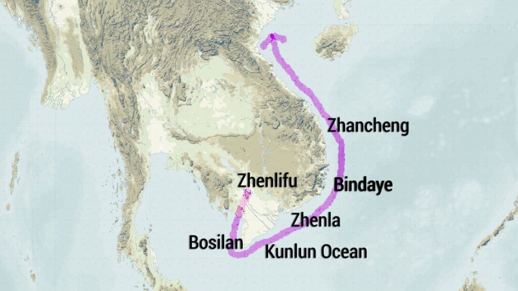
I would argue that Chinese knowledge of Cambodia in the Tang and Song periods never expanded much beyond the overland route that was recorded in the Tang period.
The only difference is that during the Song, Chinese became familiar with the far end of that route, where it entered the sea at Ha Tien, as they lost access to the other end of the route that connected to central Vietnam.
Finally, one question remains: how did envoys from Zhenla reach China during the Song. While some may have continued overland to the area of Zhancheng, I have the sense that the region of the coast where the Saigon River now flows into the sea became an access point to the outside world for Zhenla.
In Ming dynasty sources, for instance, I always get the sense that Zhenla refers to that area. So, that may have become an access point.
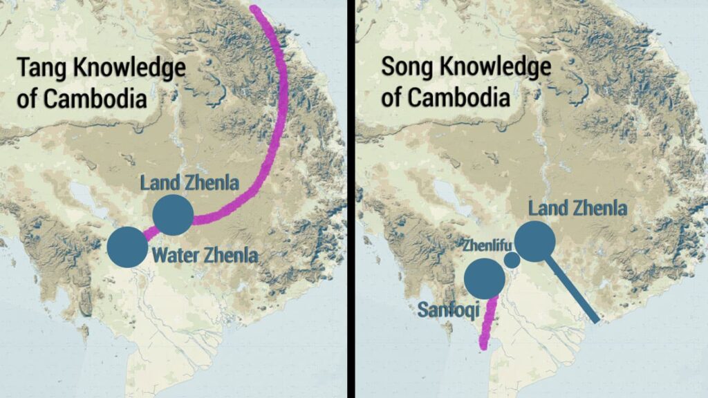
In the image above, the purple lines represent what I think Chinese definitely knew, that is, places they actually went. Additionally, they seem to have known that Zhenla could be accessed from the coast, but I have never found evidence of Chinese actually going inland from there during this time period.
On that same point, while Chinese knew that Sanfoqi was inland, I have found no accounts of anyone going there, and some trade did take place at the coast.
To conclude, the past was much smaller than we imagine it to have been. Anyone who has visited the site of some famous historical battle realizes this immediately.
An event that is described as if it was massive in scale ends up having taken place on a small field. . .
A thousand years ago, Chinese still had very limited knowledge of Southeast Asia. However, the way many scholars have written about the past assumes that they understood it largely as we do today.
As a result, there is a lot of flawed information that has been produced, like Wolters’ idea that Zhenlifu “lay to the west of Cambodia and had access to the Gulf of Siam.” Right from his use of the term “Cambodia” we can already see how distorted his understanding was.
The Chinese did not know a “Cambodia” in the Tang and Song periods. They only knew of places like Zhenla, Sanfoqi, and Zhenlifu, all places that were close to a trade route that stretched from what is now central Vietnam to the coast at Ha Tien, a route which Chinese accessed from the north during the Tang dynasty period and from the south during the Song dynasty period.


