
There is a major blind spot in the scholarship on Angkor. Scholars know that Angkor was connected by water from the Tonle Sap Lake to the Tonle Sap River and from there to the area around what is now Phnom Penh.
What happened after that is much less clear.
Where was Angkor’s maritime access point? Where did international merchants arrive? What route connected that place to Phnom Penh and then to Angkor?
Scholars regularly mention trade through the Mekong Delta, but they rarely provide any specifics.
I have argued for years now, based on Chinese and other sources, that the southern maritime access point to the Angkorian world was in the area around what is now Hà Tiên. I have also suggested that a canal may have connected this area with the Bassac River, perhaps following roughly the same course as the later Vĩnh Tế Canal.
Recently, I came across something that may support this argument in Eileen Lustig’s 2009 doctoral dissertation, Power and Pragmatism in the Political Economy of Angkor.
Lustig created a database containing information from 979 Pre-Angkorian and Angkorian inscriptions. She then used GIS to map their distribution across space and time.
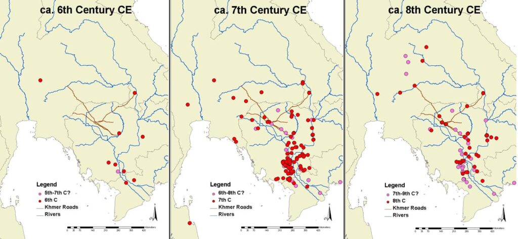
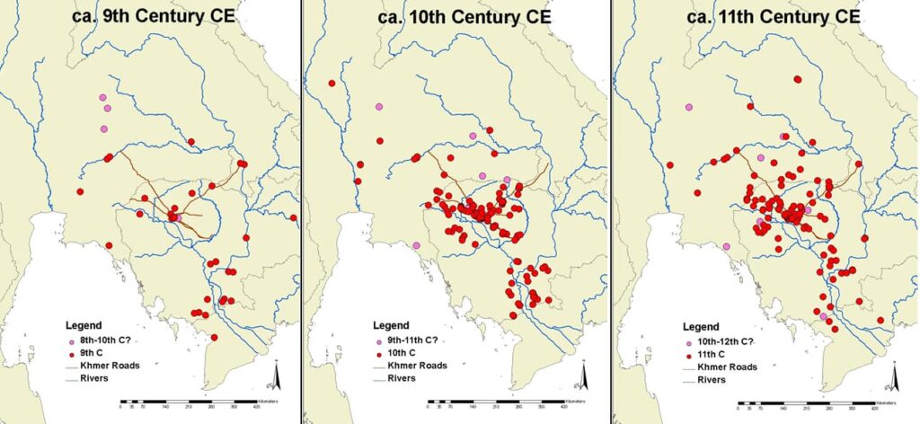
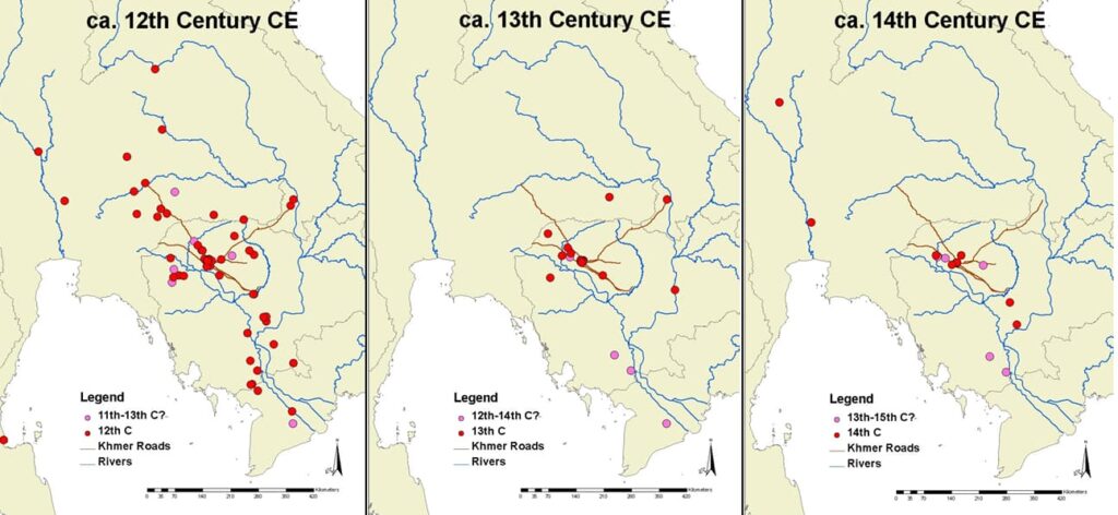
The red and pink dots mark inscription sites. The faint brown lines around Angkor indicate known Khmer roads, while the blue lines indicate rivers.
What is striking is the distribution of inscriptions south of Phnom Penh.
The center of inscription production clearly moved northward with the rise of Angkor. However, the southern sites did not disappear. A line of inscriptions continued through southern Cambodia during the Angkorian period.
Although Angkor’s connection to the maritime world was not the subject of Lustig’s research, she nonetheless recognized this pattern. She identified a major communication corridor extending from Angkor into southern Cambodia and argued that Angkor’s most important route to the sea followed the Tonle Sap Lake, the Tonle Sap River and the Mekong system.
However, she did not identify where that route reached the sea. Again, that was not the subject of her research. Nonetheless, I bring this up because this is what I find in the scholarship on Angkor more generally. There is a vague sense that trade went “through the Mekong system,” but no one seems to know exactly where or how.
That is the blind spot.
Everyone can see how Angkor was connected to Phnom Penh. After Phnom Penh, however, the route becomes vague. It simply passes into “the Mekong Delta” and somehow reaches a port that has not been identified.
However, Lustig’s map of the distribution of inscriptions points directly to the corridor that I have argued, on the basis of Chinese and other sources, linked the southern coast to the Angkorian interior.
Its concentrated southernmost examples are consistently much closer to the area of the southern coast than they are to the eastern end of the Mekong Delta.
And somewhere in those concentrated southernmost examples is the place Chinese referred to as “Sanfoqi” (Kambuja/Kampuchea).

You reminded me of “Regional Geographic Influence on Two Khmer Polities,” Journal of Third World Studies 22, 1 (Spring 2005): 135-150!
Since I didn’t read any of the languages that I mention, I assume you’ll be able to spot some errors.
Thanks, Chad. In the years after this paper was published, there was a blog called “KI Media” that was virulently Khmer nationalist (https://web.archive.org/web/20260000000000*/https://ki-media.blogspot.com). It would have been interesting to throw out some provocative questions/statements there about territory to see the responses. 🙂