In the second half of the nineteenth century, various Western scholars started to investigate what Chinese historical sources recorded about places in Southeast Asia. As they did so, they were confronted with unfamiliar names, like Shilifoshi and Sanfoqi.
In trying to understand such terms, there was one placename that played a central role, and that was Moluoyu. This name appeared in the seventh-century writings of the Chinese monk, Yijing, a man who had passed through the region on a journey to India and back.
While Yijing himself did not provide clear information for where Moluoyu was located, in the nineteenth century, when Henry Yule was translating the writings of Marco Polo, he discovered a placename that scholars who were examining Yijing’s writings would use to locate Moluoyu.
In particular, Yule found that Marco Polo had mentioned a place in Southeast Asia called Malaiur, and he argued that this was very similar to a place on the island of Sumatra that Portuguese admiral Afonso de Albuquerque had noted in the early sixteenth century, “Malayo.”
For the scholars who were attempting to understand what historical Chinese sources recorded about Southeast Asia, this “discovery” was like obtaining the first piece of a puzzle, and then then tried to connect other pieces, such as Shilifoshi, which is mentioned in Yijing’s writings in relation to Maluoyu.
As I said in the previous post, when one is examining Chinese sources, there is nothing wrong with looking for corroborating evidence in non-Chinese materials, but one should still seek to understand the Chinese sources, and to make sure that the ideas that one develops from non-Chinese sources still make sense when one then reads the Chinese sources.
However, this is not the case with the ideas that were established in the late nineteenth century by (primarily) Western scholars. Instead, when one attempts to read Chinese sources with the ideas that these scholars established about the locations of certain placenames, the Chinese sources don’t make sense.
Beyond that basic problem, when we follow the same technique of the late-nineteenth-century scholars and examine non-Chinese sources in an effort to understand placenames in Southeast Asia in Chinese historical sources, we can also find alternatives to what the scholars in the nineteenth century found, and that further weakens their claims.
Ibn Sa’īd’s Malāyur
In the thirteenth century, Marco Polo recorded information about a place called Malauir, and Yule believed that he found where Malauir was located in information that Albuquerque had recorded in the early sixteenth century.
However, if we look at writings from the same century as Marco Polo’s, the thirteenth century, then we find that geographer and historian Ibn Sa’īd recorded a quite detailed description about a place called “Malāyur.”
The information that he recorded about Malāyur was presented from the perspective of someone who was at Lāmurī in northern Sumatra and it described Malāyur as a place on the western side of the Malay Peninsula.
In the south east corner is found the town of Kalāh [Kedah], well known to travelers and renowned for its Kelāhi tin. The latitude of this town is 154°12’.
On the north east shore is the town of Malāyur, which is well known. It is a place of anchorage. Its longitude is a little more than that of Kalāh and its latitude is the same as Lāmurī. Each one of the towns of which we have spoken is on an estuary. The length of the island is about 800 miles. From the right to the left extent two capes, between which the sea is only two miles wide. The sea there is not deep. They call this place Bintan. There are found small islands out of which come black pirates armed with poison arrows and in ships of war. They rob men but do not take them away. But there are some who have been made prisoners by them. . . (Tibbets, 59)
What we can see here is that this Malāyur was to the north of Kedah. That CLEARLY was not the “Malayo” that Albuquerque later noted near Palembang.
Ok, so here is a non-Chinese source that points to a “Moluoyu-sounding” placename in a location that is different from the one mentioned later by Albuquerque. We now have to figure out which one is correct. Let’s do that by checking them both against a Chinese source.
The History of the Yuan contains a brief entry on “Siam” (Xian guo 暹國), where it notes that in 1295 (the same century as Ibn Sa’īd and Marco Polo), envoys from Siam visited the court. It then records a somewhat mysterious statement that “Because the Siamese and Maliyu’er had long been engaged in mutual hostility and killing, but by this point had all submitted and come into obedience, an imperial edict was issued instructing the Siamese: “Do not harm Maliyu’er, so that you may fulfill your word.” (以暹人與麻里予兒舊相讎殺,至是皆歸順,有旨諭暹人「勿傷麻里予兒,以踐爾言」。)
Hmmm, this Maliyu’er 麻里予兒 certainly sounds like Ibn Sa’īd’s Malāyur and Marco Polo’s Malauir, doesn’t it? And where did Ibn Sa’īd place it? A lot closer to Siam than Palembang. . .
There is more evidence that we can point to which locates a “Moluoyu-sounding” placename on the western side of the northern part of the Malay Peninsula, from the Kalyani Inscription in Bago (Pegu) to the Mahāvaṃsa (Great Chronicle) in Sri Lanka.
However, beyond that evidence, as we saw in the discussion of where the main trade corridor was in this time period in the series “From Pelliot to Wade: Jia Dan’s Itinerary Through Maritime Southeast Asia,” it also makes historical sense that Yijing would have been talking about a place related to a trans-peninsular crossing in the northern half of the Malay Peninsula.
Further, when we place it there, then all the Chinese sources make sense, which is precisely what doesn’t happen when we follow the “Albuquerque theory” and try to get the sources to make sense by assuming that Moluoyu was in southeastern Sumatra.
Takakusu Junjiro
An example of a source that doesn’t make sense when we view it from that perspective is a passage about how one returned from India to China that is included in an annotation in a Buddhist sutra that he translated, the Mulasarvastivada-ekottarakarmasataka 根本說一切有部百一羯磨.
That passage was translated into English in 1896 by Japanese scholar of Buddhism, Takakusu Junjiro (1866-1945). More specifically, Takakusu translated Yijing’s A Record of the Inner Law Sent Home from the South Seas (Nanhai jigui neifa zhuan 南海寄歸內法傳), and in providing biographical information in the introduction, he translated the passage from the Buddhist sutra about how one returned to China from India.
Takakusu went to England in 1890 where he studied Indology and then continued his studies in France and Germany. His 1896 translation is entitled A Record of the Buddhist Religion as Practiced in India and the Malay Archipelago (A.D. 671-695) by I-Tsing.
This was a landmark publication, and a significant achievement for a young scholar. However, like all pioneering works of scholarship, it had its limitations, and it was retranslated in 2000 by Li Rongxi for inclusion in the BDK English Tripiṭaka, as Buddhist Monastic Traditions of Southern Asia: A Record of the Inner Law Sent Home from the South Seas by Śramaṇa Yijing.
Here is how Takakusu translated the passage about how one could return to China from India. It begins from Tāmralipti, a port on the Bay of Bengal.
Sailing from here two months in the south-east direction we come to Ka-cha [Jiecha]. By this time a ship from Bhoga [Foshi] will have arrived there. This is generally in the first or second month of the year. But those who go to the Simhala Island (Ceylon) must sail in the south-west direction. They say that that island is 700 yoganas off. We stay in Ka-cha till winter, then start on board ship for the south, and we come after a month to the country of Malayu [Moluoyu], which has now become Bhoga [Foshi]; there are many states (under it). The time of arrival is generally in the first or second month. We stay there till the middle of summer and we sail to the north; in about a month we reach Kwang-fu (Kwang-tung). The first half of the year will be passed by this time. (xxxiv)
What Takakusu has as “Ka-cha” is Jiecha 羯茶 in Pinyin and it is a reference to Kedah. I think all scholars now recognize that. Takakusu was not sure where it was and suggested “somewhere on the Atchin coast.” (xxx).
Following that opening sentences, there are multiple problems with Takakusu’s translation of this passage. Rather than going through all of the gory details, I’m just going to re-translate it.
Here is a more accurate translation:
從斯兩月汎舶東南到羯茶國,此屬佛逝,舶到之時當正二月,若向師子洲西南進舶,傳有七百驛,停此至冬。汎舶南上一月許到末羅遊洲,今為佛逝多國矣。亦以正二月而達,停至夏半。汎舶北行可一月餘便達廣府. . .
[Tāmralipti] is the place where one boards a ship and enters the sea on the return journey. From here one sails for two months to the southeast until one reaches the polity of Jiecha [Kedah]. This is under the jurisdiction of Foshi 佛逝. When the boat arrives, it is the second lunar month.
To travel to the island of Sri Lanka [師子洲 Shizi zhou], one heads by boat forward into southwest for [the equivalent of] 700 travel stages. One stays here until winter, and then in taking a boat coming up from the south, one reaches Moluoyu in a little over a month. Now this is the Foshiduo 佛逝多 Kingdom. It is also in the second lunar month that you arrive.
One waits until the middle of summer, and then taking a boat to the north, one can reach Guangfu. . .
From Takakusu to the present, every scholar that I am aware of who has cited this passage has misunderstood the middle paragraph. More specifically, everyone has followed Takakusu in trying to get that middle paragraph to be about a continuation of Yijing’s journey, but it’s not.
Note how he starts out by talking about “we,” and then says “But those who go to the Simhala Island,” and then he switches back to “we.”
There is no “we” or “I” in this passage. This is not Yijing telling us what he did. Instead, it is Yijing telling his readers how “one” can return from India.
In this passage, Yijing describes two routes: one from Tāmralipti to Kedah, and one from Sri Lanka to Moluoyu. In describing the second route, Yijing mentions the journey to Sri Lanka and back, whereas for the first route, he only mentions the journey for one direction, from Tāmralipti to Kedah.
When we read this passage properly, we see that Moluoyu is exactly where Ibn Sa’īd stated that Malāyur was, and that it is exactly where we would historically expect ships that crossed the Indian Ocean to congregate, that is, on the western side of the trans-peninsular crossings from Surat Thani and the greater Lake Songkhla region.
Yijing wrote of Moluoyu here that “Now this is the Foshiduo Kingdom” (今為佛逝多國矣). This is a confusing statement, and we can see from Takakusu’s awkward translation that he struggled to make sense of it: “which has now become Bhoga [Foshi]; there are many states (under it).”
In modern Chinese, the characters “duo” 多 (in Foshiduo) and “guo” 國 could mean “many kingdoms,” but that is not an expression in classical Chinese. This has to be a name, and the final two characters of the name “shiduo” 逝多 are a well-attested transcription of Jeta / Jetavana in Chinese Buddhist texts. So, theoretically, this could be something like “Budhjeta.”
However, in Yijing’s other two works, we find annotations that record of Moluoyou Island (末羅遊州) that “this is the current kingdom of Shilifoshi” (即今尸利佛逝國是), and of the Kingdom of Moluoyu (末羅瑜國) that it has “now changed to Shilifoshi” (今改為室利佛逝也).
As such, I would say that this passage is either a typo, or it’s unexplainable, but either way, it does point to some way in which Foshi or Shilifoshi controlled multiple places.
The Trans-Peninsular Empire of Foshi
What I would argue that Yijing’s various comments show us is that Foshi, or Shilifoshi, was a trans-peninsular empire.
There is an entry on Shilifoshi in the New History of the Tang (1060) which states the following:
室利佛逝,一曰尸利佛誓。過軍徒弄山二千里,地東西千里,南北四千里而遠。有城十四,以二國分總。西曰郎婆露斯。
Shilifoshi 室利佛逝, also called Shilifoshi 尸利佛誓. Passing Juntunong Mountain 軍徒弄山 [south of “Champa”] and going 2,000 li, one reaches it. The land is 1,000 li from east to west and 4,000 li from south to north. It has fourteen citadels, and is administered as two kingdoms. The western one is called Langpolusi 郎婆露斯.
What I see in this entry is evidence of a trans-peninsular empire with “two kingdoms,” one on either side of the Malay Peninsula. In Yijing’s day, the western side of this empire included Kedah, and to its north, Moluoyu.
As for the Langpolusi in the passage above, scholars have argued that this is Barus on the west coat of Sumatra. Perhaps at a later time, Shilifoshi extended its influence to that area, which would make sense as that is where ships coming from Sri Lanka would pass on the way to Moluoyu, a port to the north of Kedah.
In fact, we can already get a sense of this from an annotation that Yijing made in A Record of the Inner Law Sent Home from the South Seas where he lists the following polities in the region:
從西數之,有婆魯師洲、末羅遊州,即今尸利佛逝國是。莫訶信洲、訶陵洲、呾呾洲、盆盆洲、婆里洲、掘倫洲、佛逝補羅洲、阿善洲、末迦漫洲,又有小洲不能具錄。
Counting from the west, there are Polushi Island, Moluoyou Island, this is the current kingdom of Shilifoshi, Mohexin Island, Heling Island, Dandan Island, Penpen Island, Poli Island, Juelun Island, Foshibuluo Island, Ashan Island, and Mojiaman Island; there are also smaller islands that cannot all be recorded.
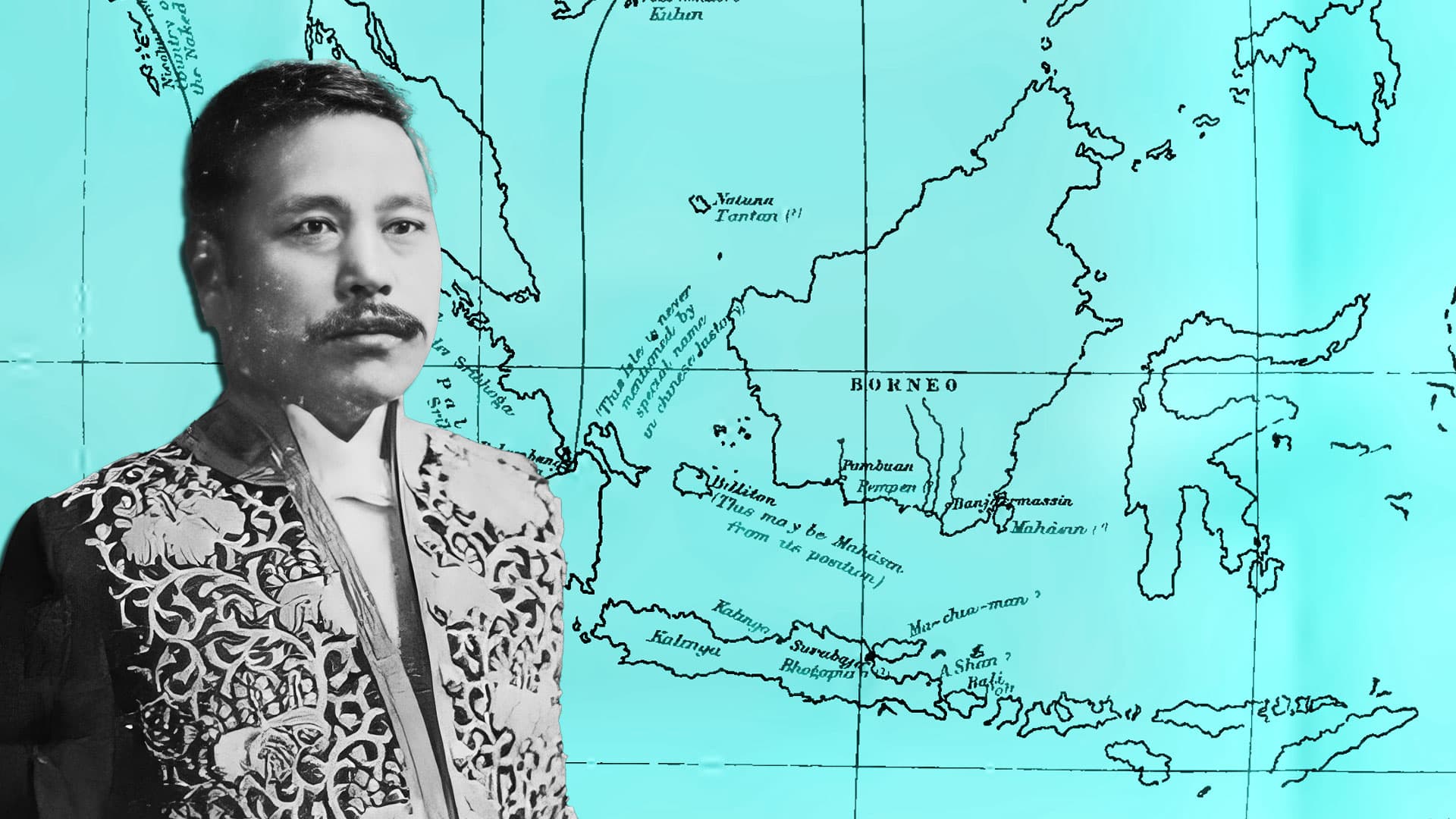
Takakusu understood this list as indicating the following:
Polushi 婆魯師: Diamond Point on the northeastern coast of Aceh, Sumatra
Moluoyou 末羅遊, or Shilifoshi 尸利佛逝: Palembang
Mohexin 莫訶信: maybe Banjarmasin on the southern coast of Borneo
Heling 訶陵: “probably taken from Kalinga,” a place on Java
Dandan 呾呾: perhaps the Natuna islands
Penpen 盆盆: modern Pembuan on the southern coast of Borneo
Poli 婆里: probably Bali Island
Juelun 掘倫: Takakusu has this as K’u-lun (as some versions of this text has Kulun 堀倫 rather than Juelun) and identifies it as Pulo Condore
Foshibuluo 佛逝補羅: Bhoga-pura, probably Surabaya
Ashan 阿善: somewhere in the eastern part of Java near Bali
Mojiaman 末迦漫: possibly Madura
As should be obvious, Takakusu had these places literally all over the map. Besides the fact that there is no logic to his interpretations, it also represents a scale of geographic space that was far larger than Chinese mariners in the seventh century were aware of.
Over and over, we see in Chinese sources from the first millennium AD that Chinese mariners were active in the area between the end of the Indochinese Peninsula and the trans-peninsular crossings around Surat Thani and the greater Lake Songkhla area. That is exactly what this list is indicating as well.
This list starts with Barus (Polushi) in the west, then it has Moluoyou/yu on the west coast of the Malay Peninsula to the north of Kedah, then it has Heling in the greater Lake Songkhla region, and eventually a place called “Foshibuluo” 佛逝補羅.
That could be “Foshi-pura,” one of the fourteen citadels that was later mentioned in the New History of the Tang. In fact, this is precisely what I suspect many of these places were. How, after all, would one know how many citadels there were in a place unless one traveled by them as one crossed the land?
In this case, that would have been the Malay Peninsula, where as we have seen in the series, “From Pelliot to Wade: Jia Dan’s Itinerary Through Maritime Southeast Asia,” Chinese trade was concentrated in the first millennium AD.
Finally, as we will see in the next post, in the more than a century since Takakusu made his (unfortunately, flawed) translation, scholars have struggled to get the above passage and the information about Yijing’s journey in his other texts to make sense based on the idea that Moluoyu was at or near Palembang.
They have struggled because the Moluoyu that Yijing referred to was not on the island of Sumatra. Instead, it was in the same place that Ibn Sa’īd, Marco Polo, and the History of the Yuan understood it to be: on the western coast of the Malay Peninsula to the north of Kedah right at the place where ships crossing the Indian Ocean arrived and departed and right at the terminus of a trans-peninsular trade route that made its way to Foshi-pura on the other side of the peninsula.